Pages

Wednesday, May 31, 2006

Indonesia Earthquake Maps and Images


As the death toll continues to grow due to the recent Indonesian earthquake more information is becoming available. UNOSAT has released a few satellite images and maps of the damage. Nothing to spectacular but look for more to come. (Hat tip: Cartography)

--------------------------------------------------------------------------------

Update: National Geographic News discusses the earthquake in context with the Ring of Fire

Cartography continues to kick booty

So is Map Room Blog

Category: Maps, Physical Geography

Monday, May 29, 2006

British Surname Mapper


Where in Great Britain are the Catholicgauzes?

To all my fellow John Bull-ers. Those of you who have Anglo roots may wonder where in Great Britain your family came from. With the Surname Profiler it is possible to map out where last names were common in 1881 and 1998.

So far this tool has helped me even more in my search for the Proto-catholicgauzes in Europe. Above is my surname's result. I claim ancestry from Stratford and there were/are some [Catholicgauzes] in that area. This mapping site is a great tool for those studying genealogy.

I wonder what the Victorians at Coming Anarchy think of this! (Hat tip: Great Map)

Category: Maps

Remembering our Troops

On this Memorial Day I recommend blog readers check out Global Security's US Military Operations page which has a near-complete listing of all American military operations from Independence to today.

Thanks troops for keeping us free!

Sunday, May 28, 2006

Virtually Visiting Aruba

The latest in a long line of virtually traveling the world. Previous editions include the world, Paris, Mecca, and the Rocky Mountains.

Aruba is a desert island approximately nineteen miles off the coast of Venezuela. The island's population is a harmonious mix of pure whites, blacks, and those of mixed South American blood. English is spoken by nearly everyone along with Dutch, a Creole pidgin called Papiamento, and Spanish. The island has a true cosmopolitan feel.

The island is a tourist attraction for both South Americans and Americans. Famous visitors include Natalie Holloway and Catholicgauze. Both these individuals were on the island at about the same time (I have managed to be one of the few people not arrested for the crime so far).

The Government of Aruba has recently relaunched its tourist website. Most geographical interesting thing on the map is a "virtual reality tour" or panoramic images which can be viewed by browsing a map. One can almost feel the heat when they look at Arikok Park.

While on my tour of the Caribbean I was (un)lucky enough to go scuba diving in an artificial coral reef right off the coast. It was a mixed experience and I'll leave you with a photo of the dive by our photographer.

Through the eye of the reef

At this level the water was warm, color could still be determined, white sand was everywhere, and the fish were beautiful

Category: Virtually Travelling the World

Saturday, May 27, 2006

The Smallest Scale Map in the Universe

Not the map but a 2-D representation. Note the lack of "here be dragons"

The smallest scale map in the universe is, well, of the universe. The scientists behind the map are with the Sloan Digital Sky Survey.

The map is being used in the study of dark matter but that is secondary to geographers and cartographers who love maps for being maps. The majority of the map shows the known universe from Earth to about 5.6 Billion Light Years away. Unlike other maps where the end of the map is an abiritory point that the cartographer detrimes; the end of this map is THE END. 13.7 Billion Light Years from Earth (that's 8.1 × 10²² miles away from Earth!), millions of light years away from anything we can see, is the end of the map and therefore the universe.

The map is in 3-D and therefore hard to be displayed. SDSS is releasing data for use in NASA World Wind (which I have a love/hate relationship with) and the public map can be viewed by using the SDSS option. (Hat Tip: atlas(t))

Category: Maps, Space

Ethniklashistan

The weekend is the time to loosen up so I thought this Onion story would do the trick.

The United Nations, in an effort to end conflicts world wide, has forced many ethnic minorities to the new multiethnic haven of Ethniklashistan (formerly the West Bank). The hope is that these groups will learn to live in harmony.

The outcome is typical for a UN effort. "Of the more than 500,000 people relocated there so far, approximately 97 percent have responded with violent resistance, swearing oaths of eternal vengeance against U.N. volunteers conducting the forced relocations." New rivalries and alliances are being formed as "Burmese Karen rebels attacked a Tamil settlement. By late afternoon, the Karens were driven back by the Tamils, who were newly armed with Israeli anti-personnel missiles smuggled into the West Bank by Zionist fundamentalists who had allied themselves–some say only as a temporary ruse–with the Tamils."

Even in humor good intentions pave the road to Hell.

Friday, May 26, 2006

Yahoo is in the Hot Zone

Yahoo is engaging in internet backpack journalism with Kevin Sites In the Hot Zone and the results are fantastic. With the backing of Yahoo News, Mr. Sites is sent to global conflicts around the world were he does first hand reporting. The website is full of useful information.

Mr. Sites has visited many countries. So far he has reported from Afghanistan, Chechnya, Columbia, The Congo, Haiti, Iran, Iraq in 2004 and 2005, Lebanon, Israel, Nepal, Somalia, Sudan, Syria, and Uganda.

On the ground journalism with this type of presentation rarely gets any better. Enjoy!

Thursday, May 25, 2006

Ask.com Update: Still Blacklisted

--------------------------------------------------------

Update: Adam recently contacted me after this blog post again denying blacklisting. He said things "take time." We shall see

Post may or may not return in full following update from Andy

Wednesday, May 24, 2006

Global-i

Usually if something is a demo for a much greater project I tend to skim over it. However, Global-i from Infomagnet allows users to see country-level information displayed on a globe. I tried the trial version and thought the product was pretty good.

The trial version allows users to examine some economic, demographic, military, and government information. Think of it as the child of the CIA World Factbook and Google Earth. The data is shown as colored spikes on the globe. Some of the interesting things to look at are AIDS rates (south Africa is in real trouble if 38+% of Boatswains have AIDS) and the corruption index (how does the practically one-party state of Sweden stay so corruption-free?).

The full version of Global-i has a much wider database available. While I will not be paying the thirty-five years a year for the full version it may be useful to some. (Hat tip: Le Petit Blog Cartographique)


Category: Atlas, GeoInfo

Top Six Military Bases in the World

Navy blogger and geography convert Eddie of Live From the FDNF recently wrote about Foreign Policy's story on the top six United States military bases around the world.

The spatial distribution of the bases is interesting. Two are in former communist countries, one is in a recently hostile country, four are in or very near Asia, and only one is the western hemisphere. The geography of the bases suggests the Middle East area will be the concentration of military action for the time being. The second area of concern is China and Central Asia. A multitude of bases could provide support for operations in that area.

The Cold War era is over and the Foreign Policy article proves it. Bases in Germany are no longer important because the USSR is gone. The only European base on the list is in easy striking distance of the Middle East.

The list is fascinating and feel free to comment about it.

Tuesday, May 23, 2006

Oppression of Muslim Women and Geography

A beautiful woman practicing modesty in swimsuit burqa / Two women oppressed in abbayas

Note: Catholicgauze recognizes the difference between cultural and religious-imposed modesty and oppression. Most rules serve as a just protector of society. Modesty is a very good thing. Catholicgauze, when he isn't being a hypocrite, tries his best to be modest in many ways. However, there are rules that cross the line and oppress groups unfairly.

Throughout time it has been rough being a woman. The role of mother and wife have been held in such high esteem that men have viewed it their duty to protect women. The protection quickly becomes control and the woman, once viewed as a personal queen, becomes nothing more than an object.

Right now the worst place to be a woman seems to be the Islamic world with a distance-decay of things getting worse as one is closer to Wahhabi Saudi Arabia.

Saudi Arabia has been seeing minor liberalization but women are being left behind. Women cannot drive vehicles, vote, use public facilities when men are present, and are even subject to Vice and Virtue police who try to prevent them from exercising outside. Some fear women excising will lead to a rise of homosexualism because the women would "become attracted to each other." Things are getting worse as the king has called for a ban of pictures of women in newspapers because pictures of women may lead young men "astray." Things can hardly get that much worse; however, with incidents like the Mecca fire where Vice and Virtue police prevented girls exiting a burning school because they would have been seen without their Islamic coverings.

Things are still pretty bad in the Middle East core. Honor killings are common for women in cases of adultery and even being a rape victim. If a woman loses her virginity before marriage she has "brought great dishonor" and is useless to the family. The only way to redeem the lost honor is to kill the woman, even if it is not her fault. Examples are everywhere. Countries like the Iraq and Kuwait have been improving with women being allowed to vote.

An outlier is Lebanon. A Christian-majority country before an Islamic population boom, Lebanon allows women to wear whatever they want (with the exclusion of the Hezbollah stronghold in the south). The “protest babe” phenomenon got its start by the Western dressed women of Lebanon.

Iran, long a symbol of Islamic radicalism in Western eyes, has actually been one of the better countries to women, besides the whole "put on the burqa because men will be led astray" thing. Women can vote in elections and enforcement is usually light. Things have taken a turn towards the scary with the possibility of religious groups (both men and women) being forced to wear identifying clothing.

The borders of the Islamic world tend to be more tolerant to women. Eastern European Islamic women dress in Western or traditional clothing and have about the same amount of rights compared to their male peers. The same goes for Turkey.

The borderland theory of people becoming more passionate as they become more distant from the core becomes evident as things take a sharp turn towards horrible for some in Europe. In the Western world where women are considered legal equals and are "liberated" some Muslim men believe their duty is to enforce Arab morals to "protect" women. Those who are "too Western" run the risk of being killed by their families. Organized groups exist to enforce harsh rules. The persecution of Ayaan Hirsi Ali is an example of what happens when a women steps "out of line."

Just as the West once had horrible restrictions on women; the Islamic world may change. Time will tell.

Category: Religion

Future of Maps

There has been discussion lately about the rise of personal navigation units and if they spell the end for the road map and paper maps in general.

Map Room Blog reports that Japanese map makers are making "value-added maps" to attract consumers. These value-added maps have extra information like history, politics, games, etc. in addition to the simple map. Sounds like my kind of map!

I expect paper maps have a great future. GPS units can provide current road information but that's about it. When I buy (or am gifted :) ) an atlas or map I like the extra stuff. Paper road maps tend to have state historical and regional information. Plus, a well done map is a work of art. Good cartographers are artists capable of making something beautiful. Finally, let's see a GPS unit have the sentimental value of old maps. Nothing can top my 1946 maps of Europe, collection of pre-World War I maps, and 1939 puzzle of the world.

Monday, May 22, 2006

Montenegro: The World's (Upcoming) Newest Country


The people of the Republic of Montenegro have voted to break away from the commonwealth-union of Serbia and Montenegro and seek a brighter future as an independent state.

The former Yugoslavia has gone through a lot since 1918, created to reward Serbs for their support of the Allies in World War I, given to the Croats by the Nazis, liberated by a communist partisan who later challenged Stalin, and then Yugoslavia slowly died after the death of Tito.

The series of conflicts known as the Third Balkans War was the last nail in the coffin. The wars were the bloodiest conflict in Europe since World War II. First there was the break-up; then there was the bloody fighting in Bosnia, finally the Kosovo conflict (Albanian thugs and Islamists versus Serbian monsters) destroyed Yugoslavia. The once Kingdom of Yugoslavia, then Socialist Federal Republic of Yugoslavia, then Federal Republic of Yugoslavia turned into Serbia and Montenegro and was allowed to rejoin the United Nations after a suspension for aggressive civil war.

Ethnicity and religion were the causes of the previous breakups (For background about nations in Europe see my earlier post). This break-up is different however. Montenegrins have been traditional close to Serbs and many identify themselves as Serb or both. The reason for this break-up is purely political/economic. Serbia has been jerks to the European Union and has been harboring war criminals. Montenegro wants to be globalized and successful but an isolationist Serbia that mourns a monster is holding it back. The election was close; 55.4% with 55% needed, but it succeeded none the less.

One has to wonder what is next. This is certainly not new for the region. Bosnia has changed boundaries many times and so have the other southern Slavic nations-states. Kosovo is de facto independent and will probably be officially independent soon. Will the ghosts of the past be pleased with the new geographical borders or will the Republika Srpska seek union with Serbia once again? Will Hungarians in northern Vojvodina break off to unite with Hungary? Finally, will the Albanians make grabs for land in Macedonia? Time will tell with the land of southern Slavs can move on into the global era or if they will be stuck in the dark ages for some time more.

Side Note: What would a
post-Lebanon political rally be without a protest babe or two?

Category: GeoInfo, Geopolitics

Sunday, May 21, 2006

Supermarket Battle: Wal Mart and Carrefour

A Catholicgauze Map. Click to Enlarge

We all know about Wal Mart. Love it, hate it, or both everyone in America and many around the world have an opinion about the 800 pound gorilla of the retail world. But how many of us know about Carrefour? I am sure many of my European readers do. I decided to do a simple investigation and I learned about marketing strategies, political influence on economics, and globalization.

Introduction:
Carrefour is the creation of French business partners who started the company in 1957 and is second only to Wal Mart in the retail business. Carrefour is the company which started the supermarket and hypermarket store style. It also made popular the idea of selling base food products at extremely low prices. The practice was known as produits libres or free products.

Wal Mart is America's, unknowing at the time, answer to Carrefour. Originally in the department store business Wal Mart has spread out and has managed to become America's largest grocery store with over 14% of all groceries being bought from it. To many Wal Mart has become the symbol of American capitalism; the only thing left undecided is whether that is a good or bad thing.

Spatial Distribution:
Wal Mart's primary core is North America. With nearly sixty percent of their 6,556 stores in the United States the business is centered in America. There has been recent expansion into Central American countries that are friendly to the United States. This has been profitable but controversial. The passage and NAFTA and CAFTA have allowed money to be easily transferred between these countries. Wal Mart has become an example of how interconnected the continent is.

Europe is Carrefour's core with a Wal Mart beachhead. France is Carrefour's home; nearly 50% of all global sales happen in the 3,704 French stores. Carrefour nucleus is the Romantic core of France, Belgium, Italy, Spain, and Portugal. New European Union and wannabes form the outer Europe region. Poland, Greece, Romania, and Turkey started having Carrefour stores in the early 1990s.

The Wal Mart hold can be found in the Germanic countries of the United Kingdom and Germany where there are no Carrefours to be found. These are weak links in Wal Mart's chain however. The United Kingdom the international leader of Wal Mart sales but done under the flag of ASDA. The German branch has not been very successful due to German labor laws and interference from governments making it hard to obtain building permits.

South America is a battle ground. Carrefour has had a presence since 1975 in Brazil but Wal Mart is trying to become the retailer of choice. Their problem though is geography. Countries on the eastern coast of South America tend to identify more with Europe than the United States. Europe is the place to send kids off to college and the place to vacation. The reserve is true for Central America and the western coast of South America.

Asia is the second battle ground. French ideals of internationalism seem to be the cause of their expansion into the area before a more isolationist America-based company did. However, Wal Mart is staging a coup. In 2002, Wal Mart allied with the powerful Seiyu Group in order to become an economic player in Japan. By 2005 all of Carrefour's Japanese stores were sold. Wal Mart is also making a play for the Chinese market; a sort of home coming for the company. The free reign that businesses have in China, while being under strict political controls, should make for an entertaining battle.

Interesting Notes on Globalization
Many of Carrefour and Wal Mart's international stores came in the early 1990s after the fall of communism. The fall and disgrace of international socialism became the dawn of the new age of globalization.

Leslie White once said that energy consumption was the best way to measure how advanced a culture was. In this globalized age; a way to measure how globalized a country is to see if they have big name international businesses (that's my idea; unless of course somebody else wrote about it before me, then it is their idea). Using the two retail stores it seems North America, Europe, most of South America, and most of the Asian rim are doing pretty good.

The areas not globalized are those areas discussed by me in the Arcs of Instability and Thomas Barnett's work. Africa, the Islamic world, and central Asia are all lacking the big names.

As mentioned before the attitudes towards the international scene have influenced expansion. France traditionally has been more cosmopolitan than the isolationist-prone United States. Carrefour has spread all throughout the world fairly evenly while Wal Mart has tended to focus expansion in its native North-West Hemispheres.

I personally wonder why Scandinavia is lacking a Wal Mart or Carrefour. Does strong socialism scare these companies away? Also lacking is Australia and New Zealand. These two countries are in the Anglo-sphere and prime ground for Wal Mart.

Category: Maps, Miscellaneous

Weekend Blogosphere Update

Be sure to check out the growing blog roll on the side.
--------------------------------------------------------------------------------

A look at other geographical blogs:

TDAXP
is still in China. He has visited the Great Wall, gone to all the places that sound like Heavenly Spirit Gardens, and even supported local business by shopping at a Chinese Wal-Mart. His constantly updating China posts can be found here.

My good buddies at Platial continue their drive to world domination. They were recently at XTech where they talked about the Geography of Platial. Looking at their map of tags one is struck by cores which center on the US, UK-Low Countries-Germany-Italy, and Japan. But what about the so-called "flyover country" in the United States, why does it not have as many tags? Does the Midwest have nothing interesting? Do not answer that question!

Finally I stumbled across Julius’ Travels in the South. The man is photoblogging his experience in Antarctica. Sure the updates are not as common as mine but the man is photoblogging from Antarctica! Want to know the going on's way down under? Then look no further.

Views of the Earth

Christoph Hormann has been one busy man. He has taken satellite data and into faux low orbit pictures of the Earth. He has released some of his images on his website Views of the Earth: Artificial Images of Our Real Planet. One can view his gallery via a list or map. My favorites include Alaska and the Himalayas in Nepal. Enjoy! (Hat Tip: The great Map Room Blog)


Category: Physical Geography

Saturday, May 20, 2006

Google Maps Goes Native

Recently I was browsing Google Maps when I noticed Turkey was spelled funny. I then saw Greece being spelled in Greek. It did not take long for me to realize the countries were being spelled as natives spell them. I was about to do my old rant of "we don't call Germany Deutschland, when I saw Google Maps does.

It appears any country with road detail is spelled in the native language. I suppose this makes it easier for people who want to search for directions and related tasks. I only wish there is an option for English-language place names because I have no idea of where exactly I am looking at right now.

Google has a standard and keeping to it unlike other places which flip-flop on name policies. Good for them.

Friday, May 19, 2006

Ask.com: Big Meanies?

Ask.com did fix their mapping errors but kept the blacklist going

TDAXP is on the case!

Ask.com contacts Catholicgauze! Check the comments section for the discussion so far
-------------------------------------------------------------------------------------
Ask.com Maps is a joke. The "cartographers" they hired to make their physical world map made mistakes then made more mistakes in an effort to fix the first errors. Embarrassing for Ask to say the least.

Throughout the past few days I have received hits from IP address from Ask.com. So did Ask fix their map problem or reply to concerns? No, they blacklisted Catholicgauze! When one searches for "Geographic Travels with Catholicgauze" or even "Catholicgauze" there are no results which directly lead to this blog! They honor other blogs like TDAXP. Yahoo and Google will show Geographic Travels with Catholicgauze at or very close to the top of “Catholicgauze” searches.

Why Ask? I point out a problem and you try to bury me and leave the problem alone. I really want to like your map service and even stated that. Your behavior of blacklisting users while being kicked around by Google is shocking.

As for blog readers I recommend you view the Great Lakes of the Outback on Ask Maps

Ask.com Maps drops the ball- AGAIN

Update: Ask.com may have blacklisted Catholicgauze. They deny it, so far but Catholicgauze doubts their claim.
-------------------------------------------------------------------------------------
Ask.com is trying. I do have to give them that. But dang it why don't they hire a cartographer? I'm sure there are a ton of professional and amateurs on the internet who would gladly help them out in an open beta for free. But they dropped the ball again.

After my review made some (minor) waves on the blogosphere it appears Ask.com tried to fix some mistakes with their physical map. The Great Lakes returned to normal and the Caspian Sea was taken off the clean and clear. All seemed right, but bad cartography still ran rampant. First was the forgivable sin of the Aral Sea doing rather well for itself. Then I noticed water problems in the Middle East were solved with the great lakes of Iraq. Egypt and the Sinai had new lakes. Finally, Lake Chad had babies.

There are inexistent lakes and rivers all over the place. It is like a glacier came over the world, drilled water bodies everywhere, and went away.

I know people from Ask.com have read my review. I really want to like your site, I really do. But please do some research!

Official Language and Official Languages in the United States

The United States Senate voted recently to make English the official language of the United States then it voted to call English a common and unifying language. While the rest of the nation struggles to understand just what that means; one may be interested in knowing many states are already officially English and some states and territories are officially bilingual or even trilingual.

Twenty-six states and the Virgin Islands all have English (American version) as their official language. There has been controversy; however. Arizona once tried to make English its official language but was stopped by the state supreme court which ruled the law "too board." The law resembled Quebec’s French first law where store owners could be punished for not printing text in official language.

Some parts of the United States are bilingual.


There are outliers with these facts too. New Mexico government's uses both English and Spanish while not having any official language(s). South Dakota's state constitution was printed in multiple languages because the various immigrants groups distrusted each other. Pennsylvania recognized English and German until the 1950s. The United States census conducts surveys in English, Spanish, Chinese, Korean, Vietnamese, and Tagalog (Philippine). Finally, various Indians reservations use English and native languages interchangeably.

If English does become the official language of the United States it would be interesting to see if the bilingual states and territories will be grandfathered in or if the law would overturn multilingual laws.

----------------------------------------------------------------------------------------------

What type of American English do you speak? Find out with Yall Tock Funny Ya Hear

Want to find out the difference between American English with that from the motherland and Australia along with Cajun versus Fromage? Find out with Figjam

Category: Languages, Maps

Thursday, May 18, 2006

Violence in Sao Paulo

Collage by Coming Anarchy

This past week has been the scene of great violence in Sao Paulo, Brazil. The events have traits of the past and show a possible future for America and the rest of the world.

Coming Anarchy has a great rundown of the genesis of the violence but here is the jest of the problem. The Brazilian government has begun a crackdown against the First Command of Capital (PCC), a violent gang that uses money raised from crime and member dues to bribe police, judges, and politicians. When police were transporting several leaders to jail the PCC launched a raid against police stations and killed several cops. The violence is spinning out of control as over 150 people have been killed as police and the PCC turn one of the largest cities in the world into a battleground.

Sao Paulo is turning into a contested ungoverned space as defined by Francis Galgano in his paper Geographical Analysis of Ungoverned Spaces. The PCC wants to create a new network of rules while the civilian police are fighting to preserve order. Both groups are undersized and know much about each other; this limits them to a long and bloody stalemate until one side gets tired. As history has shown with the New York draft riot, Tulsa race riot, and the race riots of the 1960s it takes an outside force to come in and end the violence. However, the governor of Sao Paulo has turned down an offer of military aid from the president.

So what will happen in Sao Paulo? I am convinced Brazil will not let the PCC establish an open network so eventually the PCC will be beat back but the question will be how. It is unlikely that the PCC will back down from the state police so the two more likely outcomes will be either the governor will let the military in after the violence gets even worse or police will set up their own paramilitary group like Los Pepes or Sombra Negra. Expect a lot of people dying either way.

There are lessons for the future from Sao Paulo. America has been paying lip-service to problems caused by groups like MS-13 who are creating their own ungoverned places and Europe faces organized groups of Islamists who wish wage jihad against the West. These countries need to realize the problem they face or risk having Sao Paulos in Los Angeles, Paris, and London.

Category: Geopolitics

Wednesday, May 17, 2006

Online Atlases of the World

The one thing that makes a better gift than a map is an atlas. So when Catholicgauze discovered a plethora of atlases online for free his day was made. Two of the online atlases are actually government projects and have tons of detail of their states while the third is a private project with general map information of the world.

The Atlas of Canada (English/Fromage) is a project of the Canadian government to provide "authoritative, current and accessible geographic information products at a national level." The atlas has a multitude of interactive maps to view depicting everything from average maximum snow depth to historical treaties with the First Peoples. What really takes the cake for me however are the topographic maps of Canada.

The National Atlas is a project of the United States Department of the Interior. Maps are more interactive with layering options. The maps range from harvested crops to seismic hazards. All around the National Atlas is a great interactive mapping website.

The last online atlas site is Multimap. Multimap provides mapping technology to businesses in Europe and on the side offers free mapping information to the general public. The maps are political/road maps viewable from national outline to down to 1:5,000 (street level) depending on the place's location. Catholicgauze recommends the France, Germany, and Great Britain maps for the most fun. The whole world is also zoomable to an extant.


Category: Atlas, GeoInfo

Monday, May 15, 2006

Indians along the Oregon Trail in Kansas

Memorials, monuments, and interpretative centers are spots were generations create their own version of the past. To see a constructed image or text is not necessarily seeing how things were but how things were thought to be.

Recently I started some serious research about the Oregon Trail. Along the Oregon National Historic Trail I have found some interesting depictions of American Indians. Three interesting examples can be found in Topeka, Marysville, and Saint Mary's, Kansas.


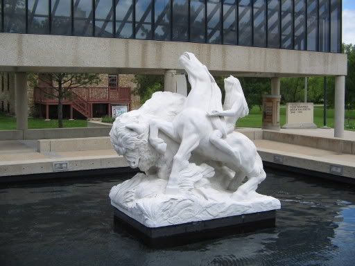
In Topeka there is a statue of an Indian along side a white buffalo outside the Kansas Historical Museum. The craving is called "The Great White Buffalo." This is something because the Indians in this region were Pawnee, Kaw, Pottawatomie, Kansas, and some others; but not Sioux who believe in sacred white buffalos. Either there was been cross-cultural adaptations of legends or; more likely, somebody believed all Indians are the same.

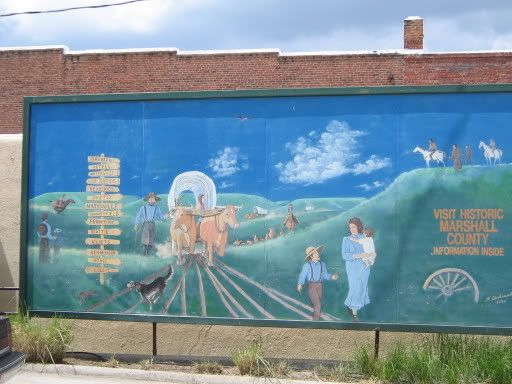
In the town of Marysville there is a mural showing pioneers on the trail. There is a father, mother and child, older child, and of course the family dog enjoying their trip to Oregon. On the hill there are some Indians observing the wagon train. That is it, just observing. While many Indians traded, helped, or hindered emigrants in real life these imaginary Indians are good for nothings just taking a passive role in history.


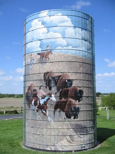
Outside of Saint Mary's, base of the Society of Saint Pius X in Kansas, Westar Energy operates the Oregon Trail Nature Park. The park is a nice collection of walking trails with some beautiful views of 
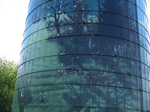
Kansas. However, the main attraction is a painted tower with depictions of the Oregon Trail imagined by some artist. There is the emigrant family in green grassland, Bambi and friends in green grassland, and the above photo of an Indian hunt in brown grassland. While the grass is more accurate of the region the painting is questionable. The use of paint on the horses also reminds me of distinctly Sioux designs. The Indians are muscular, noble savage braves who are merely running the buffalo into a ditch while not using weapons. I guess blood and guts would not be family friendly.

Three examples of Indians, three different worlds.

Sunday, May 14, 2006

Indonesian Volcano Stupidity

I shall be on the road all day Monday so here is a post to entertain you until sometime Tuesday

Volcano Mount Merapi is on the verge of exploding. The last time this 4,000 year old rock exploded over 1,400 people were killed and 13 villages were destroyed. So what are the locals doing? Nothing. Most are defying orders to leave the smoking mountain and some who did evacuate are returning! Kind of reminds me of another evacuation snafu...


Category: Physical Geography

Amazonian Stonehenge


Archeology continues to be in the news with the announcement of the discovery of a possible "Amazon Stonehenge" in Brazil.

Archeologists say it could be an observatory/temple because the blocks are arranged in alignment with the winter solstice. The path of sunlight through the rocks could have possibly been to calculate time of year. This is evidence for a calendar. Scientists say the ruins, if they are ruins, are between 500 and 2,000 years old.

As one can tell from the picture, the Indians of the Amazon were better at astronomy than architecture. The possible ruins put the Indians on the same astronomical development with whoever built Stonehenge (constructed well before the Druids) and the Egyptian Pyramid makers- both who did their work around 4,500 years ago. However, while these Indians were just learning to cut stone into pretty patterns the Inca created roads, and the Maya and Aztecs made great cities and astronomical calendars.

Category: Archaeology

Saturday, May 13, 2006

Catholicgauze scoops National Geographic

Geographers have always had an "interesting" relationship with National Geographic. It does great things like promoting geography education and the Genographic Project (which has been used and blogged by Catholicgauze not once but twice). However, recently they have become more political and have turned away from geography with cover stories on love and poison. The latter angers many geographers who have viewed National Geographic as the face of geography to the masses. The former upsets readers who view themselves right-of-center and others who reject National Geographic’s dogmatic stance on issues.

Now National Geographic has adopted the bad habit of reporting debunked junk stories. First there was the whole Gospel of Judas fiasco and just now National Geographic News is reporting "Pyramid in Bosnia -- Huge Hoax or Colossal Find?" If National Geographic read my update on the "pyramids" they would have realized this guy is a nut job weeks ago.

I know people at National Geographic are good people. They want to educate the world and make it a better place. Publishing junk stories; however, is not a good start.

Tags: , ,

Disputed Small Islands

... or the Geography of No One Cares! There seems to be something with small, insignificant islands which make them the hot point of international disputes. Some are near-humorous, some seem pointless, and some have nearly caused wars.

Nymark: A recent glacial retreat has unveiled several new small islands in the Barents Sea well north of the Arctic Circle. British artist Alex Hartley has claimed one of these small islands as his own and named it Nymark. He states he wishes to create a democratic republic and has even petitioned the United Nations for recognition. Norway, which has been given land in this region by international treaty, has told Hartley to bugger off. Norway claims many people have claimed small islands in this part but no claims are valid expect for Norway's.

Hans Island: You think two progressive countries like Canada and Denmark would get along. You think that these two countries would have nothing to argue about. You think wrong. Hans Island is a small island right in between Canadian artic territory and Greenland. It is a small rock right on the border line in the Kennedy Channel. Both Canada and Denmark have been jerks with the issue sending troops to place flags and have Coast Guard-like ships encircle the island every so often. Canadian Geographic has created a website dealing with the Hans Island debate.

On an interesting side note: Canada claims land and sea extending all the way to the North Pole; a claim not recognized by the United States.

Perejil: Isla Perejil is a small island off the coast of Morocco governed by Spain since 1668. Morocco, already upset about Spanish ownership of Ceuta and Melilla, invaded the island to test Spanish resolve. Spain's response to the first invasion of a Western European country since World War II was to send in Spanish troops. The Spaniards peacefully evicted the Moroccan soldiers. The United States was able to negotiate a return to the status quo and to this day Perejil's population consists of a few goats.


Category: Geopolitics

Friday, May 12, 2006

TDAXP in China

Friend TDAXP has somehow managed to end up in the People's Republic of China. For a while he will have running updates of his journey. So far he has photoblogged:


I hope and pray for his safety and a Chinese Bishop's hat!

Geography of American Sports

Matt Rosenberg of Geography@About.com (who was kind enough to link to Catholicgauze) created in 2000 a series of maps detailing the geography of pro sports in the United States and Canada. By viewing the maps it is fairly easy to see spatial trends among sports.

Baseball: Major League Baseball is an old organization with roots going back to the 1800s. Because of this most of the teams (especially those who have been established for a long while) are north of the Mason-Dixon Line, north of the Ohio River, and east of the Mississippi River which was the settled area at the time. There are a few outlier teams in the south and elsewhere. A secondary core has formed in California with the oldest teams there since only 1958.

Basketball
: Basketball has three cores: the northern core, the southern core from Florida stretching to Texas, and a Pacific core from Southern California to Vancouver. There is a pocket of outliers in the Interior West.

Football: The National Football League is surprisingly centered in the east. The northern core is there with a spattering of southern teams. Texas only had one team at the time which is shocking for the "capitol of football." Only ten teams are west of the Mississippi River and two of those teams are right along the river's banks.

Hockey: The National Hockey League is becoming more American and less Canadian. Only six teams remain in hockey's homeland. Some of them have moved to the South where a new core is forming. The South differs from the traditionalist Canadian core with more flashy presentations and "family-oriented" events. The Atlantic seaboard is home to many teams. California and the Great Lakes region have the small remainder of teams.

Category: Maps Sports

Wednesday, May 10, 2006

Walking England

Back in my high school days I bought a travel magazine which described the famous Coast to Coast walk in England started by Alfred Wainwright. The article so appealed to me that I vowed to get in shape (I was tubby once) and walk the path. I have trimmed myself down and gotten in the habit of walking everyday but the trip to England still alludes me. However; I can partly enjoy the walk through books and the internet.

The Coast to Coast walk itself starts in St. Bees by the Irish Sea, goes through Richmond, past three national parks, and ends at Robin Hood's Bay on the coast of the North Sea. The trail is slightly less than 200 miles long and takes about two weeks to complete. Elevation is a factor due to many hills and valleys. Most people go west to east so the wind is to their backs.

There are many useful sites on the internet. Coast to Coast Path: A Walk Across England provides an excellent day-by-day break down of the hiking trek. There are also many personal websites describing individual's experiences. One may also wish to read my previous post on a picture database of Great Britain to have a greater sense of the lay of the land.

Many books are now available on the walk but Wainwright's updated original is still the primary source to go to. The book is updated for path openings and closings, provides detail descriptions of the walk, and gives humorous asides.

Even though I am not on the trail now it is always fun to study up on a possible adventure.


Category: Virtually Travelling the World

Tuesday, May 09, 2006

Geography and Film: Falling Down


Falling Down is a movie which follows William Foster's attempt to "go home."

*****Movie Review*****
Bill Foster's effort to survive Los Angeles and "go home" are portrayed well in this "tale of urban reality."

*****Geographical Review*****
The early 1990s were rough on Los Angeles. The Rodney King riots occurred and there was an economical downturn which led to large numberings of lay offs. The main character, Williams, was a government defense worker before he lost his job and snapped at the beginning of the film.

The first incident in the film occurs at a convenience store. The convenience store is manned by a Korean who over charges and is "not a people-person." This alludes to the perception of the alleged swamping of convenience-stores by Koreans. This stereotype was so wide-spread that Koreans were targeted in the Rodney King riots for alleged wrongs against the black community.

Next up on Williams' tour of destruction is Angel Heights. This neighborhood is depicted as a barrio full of gang warfare. The people in this area are Hispanics who walk around working-class buildings with Hispano graffiti. In reality the gang problem seems to be becoming worse as groups like MS-13 acquire more weaponry and commit greater acts of targeted violence.

Another vernacular region is the country club area. This section of town has grumpy old white men playing golf. Houses nearby are huge mansions owned by wealthy doctors. The whites have cut themselves away from Los Angeles proper with gated communities and member only activities. Gated communities were and still are on the rise of the wealthy who can afford to live in them. The perception of those who live in them as being snobby and isolationist has also grown with the trend.

The final region is the pier nearby William's "home." The ocean is scene as the end point and place for salvation.

The movie does a good job of giving each neighborhood its own feel. It also is a good survey introduction to the make-up of Los Angeles and the people which combine to form its society.

Category: Geography in Movies

Ask.com Maps Review

Ask.com has tried to fix their mistakes listed below (so the links no longer show what I talked about) but made new ones. Read about it here. Also, Ask.com may be blacklisting Catholicgauze.

-----------------------------------------------------------------------------------


Ask.com has decided to take on Google Maps and the rest of the group by releasing their own map site.

They have the usually street and aerial maps. There claim to fame is the ability to look at the globe physically with a relief map. While this would be a useful tool and original for neogeography Ask.com drops the ball- BIG TIME.

The map's "cartographers" are either really big Al Gore fans or do not know their geography at all. Everything above sea level is land and everything below is water. What does this mean? Goodbye Great Lakes, so long Netherlands, hello Dead Ocean, and it appears the Caspian Sea is on steroids. Other land/water can be found on the relief map.

Until Ask.com gets its act together this is a great opportunity to be original wasted. Stay away from their relief map for now.

One star out of five.

A GREAT AND MIGHTY HAT-TIP TO MAP ROOM BLOG!

Monday, May 08, 2006

Geography of Food: The Pasty

The pasty is a hearty food. Inside a thick crust can be found diced meat along with potato, onion, rutabaga, and other vegetables. Common toppings include salt and ketchup, lots and lots of ketchup.


The Geographic Travel of the Pasty:

The pasty in its present form came from Cornwall, England. The reason for the creation of the pasty in Cornwall is because of the tin mine industry. Miners needed a filling food which could stay warm for hours and also supply vital calories. The food also needed a thick crust because tin on the finger tips would leak into food and act as a poison. The pasty was invented to fulfill this need. A combination of meats and vegetables was kept warm for hours in a thick crust. A ridge on the crust, designed to stop the poison from spreading into the food, could be held and thrown away.

The pasty was a huge hit with the Cornish miners. It quickly became a common dish in Cornwall in pubs and homes. When Cornish miners immigrated to the United States and elsewhere the pasty went with them.

Probably the most interesting place the Cornish and pasty went was the Upper Peninsula of Michigan. The Upper Peninsula (UP) has many resources including iron, copper, and silver. Small groups of Cornish immigrants migrated and became miners. Along with the Cornish were Finnish miners who adopted the pasty. Later even more Finns migrated to the UP. They saw their countrymen eating pasties and assumed it was some sort Finnish invention. The pasty was quickly adopted it into UP-Finnish culture. Today the UP is the only area of the United States with a Finnish plurality and the pasty is everywhere.

Doing a simple internet search will reveal an almost 50-50 split between the Cornish pasty and the "Finnish" pasty. Some of the top hits are from pasty shops in Michigan who will sale pasties over the internet. Pasty sales hit a high during the colder months but are common all year round. If you are ever in Cornwall, stop in a pub and enjoy a pasty with your drink. If you are ever in the UP, enjoy a pasty and do not forget to have ketchup, lots and lots of ketchup.

Sunday, May 07, 2006

Belgium Bishops and Illegal Immigration

You see this outside your church you know something is wrong

UPDATE: Its not just European Catholics but Protestants also. On Palm Sunday a Protestant church celebrated the birth of Mohammad! Mohammad, the writer of the violent, hateful passages I blogged about. What the %^$%!

The pastor said "“Today we remember the birth and life of Muhammad and the beginning of the week of the passion of Christ, leading to Good Friday, the day Jesus of Nazareth was crucified.”

Maybe he should read Catholicgauze on the Koran!

----------------------------------------------------------------------------------

The issue of illegal immigration is complex beyond imagination. I have my own opinions on the matter but they are irrelevant to what I am going to blog about.

Belgium Bishops have allowed illegal immigrants to stay in cathedrals out of belief the government will respect church property. Everything was going well until many of the people taking shelter, mostly Muslims, began to desecrate the church. Banners stating "Allah" were hung up on the church, the Virgin Mary was covered up so not to offend the Muslims, and the alter was moved so a mini-Mosque could be created.

The Church offers service to others "not because they are Catholics, but because we are Catholics." That's a great way of thinking and doing charity but what about keeping a Church sacred and being proud of one's beliefs?

Category: Religion

Prehistoric Archaeology of the Aegean

Today's Sunday and I am crashing because I just got a ton of work done.

As readers know I am a fan of archaeology. It is a perfect marriage of history, geology, and geography in my mind. This is the reason I was thrilled when I found out that Dartmouth College (which has excellent an excellent geography department) released a lesson plan-website dedicated to the prehistoric archaeology of the Aegean Sea. Everything from the Trojan War to grave styles and more are covered. There is a ton of reading involved and its best to take in small pieces but it is surely enjoyable. Have fun!


Category: Archaeology

Saturday, May 06, 2006

Geography of LOST

Platial's blog and conversations with TDAXP has led me to discover some interesting sites that discuss the geography of LOST via neogeography.

First up is the Platial map of the filming locations of LOST by Tracey the Astonishing. Wanted to know where on the island of Oahu a scene was filmed? Here you go!

Second up is the Platial map of places depicted in LOST. Try to see if there any spatial patterns in this deep show.

Finally a student at Iowa State has a Hatch page which has oodles of maps of the island.

Category: Miscellaneous

Friday, May 05, 2006

Battle for God in China

Inter-religious wars are brutal. Each group thinking their side has divine support while the others merely worship air. Intra-religious battles; however, can be even more brutal. The enemy is not some heathen who does not know better but a heretic apostate who knew and rejected the truth. The bloody Sadr-Zaraqawi tick-for-tat antics demonstrate this well. The battles do not have to be physical. The battles can be like the current conflict between the Catholic Church and the People's Republic of China.

In the last few weeks strange news was coming from China. The Communist (yet capitalistic) government announced it may allow the government-approved Chinese Patriotic Catholic Association to be absorbed into the Catholic Church. In return the Vatican would end recognition of Taiwan and recognize the PRC.

The talks were going well until China announced it would ordain two bishops without Rome’s approval. The Hong Kong Roman Catholic Cardinal responded by calling for talks to end. The Vatican is now debating whether or not to excommunicate the bishops. Currently it is mulling over reports that state the "bishops" were under duress.

American Papist is having an updated rundown of the account at The Chinese Excommunications: Finding Answers.

The Chinese Patriotic Catholic Association was formed because the Communist government thought an independent religion could bring down governments. It has rejected Catholic law changes since the 1950s including Vatican II. For a while they even did Latin Mass until changes were made in the 1990s to bring Mass in line with other Catholic Masses. Estimates state 80% of the Chinese bishops are in secret union with Rome. Most bishops appointed by the government ask for approval from Rome first.

The Catholic Church is not the only religion run by the Communists:

Christians in China not under government control practice in "house churches" and have reasonable fear of government clamp downs. While only a minority of Chinese is Christian; the People's Republic of China is in the top five countries with most Christians according to Philip Jenkins in his book The Next Christendom.

It will be interesting to see what happens. Will the Church and Communists resume dialog, will Benedict XVI fight government-control like John Paul II did and inspire new Lech Walesa's, or will the status quo hold of both sides ignoring each other? Only time will tell.

Category: Religion

Thursday, May 04, 2006

Geographically Dumb Americans

A while back I was in the break room of my former job and talking to my manager. He was from Britain and I was telling him what I wanted to do for a career. When I told him that I wanted to be a geographer he was impressed. He stated many Americans do not know geography and talked about his schooling and what he was taught. He told me all about Oxbow Lakes and other physical features.

I realized just how horrible American geography education is. When I was in high school the class was taught North America's countries and maybe something about the country's relations with the US. My British manager was taught not only human geography but physical also. He knew various theories and could talk about the various fields of study.

I knew then Americans were bad at geography but I did not know how bad until recently. My good friends at National Geographic have released yet another study of Americans not knowing regional geography.

The horror highlights include:

  • 90% thought knowing the locations of countries in the news was not important
  • 75% could not locate Israel on a map of the Middle East
  • 60% were not to find Iraq on a map of the Middle East
  • 47% could not find India on a map of Asia
  • 30% thought the most heavily fortified border was between the US and Mexico


Harm de Blij would be rolling in his grave if he was dead.

Other geographical subjects are important. Knowing urban planning can help one figure where the best housing prices will be. American cultural and social geography can aide those who wish to market products. Knowing soil geography can tell one if there house will fall in a sink hole or erode into the ocean. All geographical fields are important yet schools only teach World Regional and they fail at that. I think teachers should take a page out of the British school system and find out what Americans are doing wrong.