Pages

Thursday, November 30, 2006

American, British, and Canadian Citizenship Tests

Every year thousands of immigrants take citizenship tests to gain all the benefits a native does. To pass the test one needs to study intensely. The surprising thing is many of the immigrants who pass the test know much more about their new country than many of the native-born citizens.

Catholicgauze invites his readers to try their best to prove their citizenship in their own country and even see if they can defect!

Wednesday, November 29, 2006

No-Go Areas of France and the rest of Europe

2011 Update:  Scotland Yard and local Muslims are organizing a radical Islamist effort to establish sharia micronations in London.  These micronations are a threat to not only native Europeans but the majority of Muslims who do not wish to live under an Islamist tyranny.


Note: No-Go Zones are the product of a radical ideology. Catholicgauze denounces all radical ideologies including Nazism and racism. "White Nationalism" is just as bad as Islamic Separatism.

An increasingly commonly thing in European cities is the no-go zone. These are places where the police, medical rescue crews, and other government agents will not venture into. The areas are viewed as just too violent and/or risky to enforce rules. Following the rules of ungoverned spaces, anarchy does not reign for long. A group will enforce their own rule set and the no-go zone will become a microstate.

In France no-go zones are referred to as Zones Urbaines Sensibles (Sensitive Urban Zones).  A few are truly no-go zones while most are just areas where the government is focusing more devlopment and police require special procedures to operate.  A few (NOT ALL of the 751 ZUS, as falsely report in "anti-jihadist blogs," of these zones, primarily around Paris) are under control of radical Islamists. From these no-go zones around Paris and other urban centers, Islamic militants are waging a cultural and sometimes even guerrilla warfare against French police. The police are now taking to the streets in protest against the violence targeted at them in Lyons with police unions claiming there is a civil war against them.

It is important to remember that the Islamist movement in France is small overall.  However, the much larger issue of racial discrimination of French against Muslim ethnic groups feeds into the Islamist movement and non-Islamists will commit violent action in favor of Islamists because it hurts the French rule-of-law.

The rest of Europe is going down a similar path. The United Kingdom is wondering if different groups should be under separate laws. If this were to happen with official approval it would only be a matter of time that political unity would be called into question. Europe, with a dying population and hostile race relations, faces a bleak future.

Tuesday, November 28, 2006

Oxford's 2006 Year in Review

Once again Oxford does their annual update on the geography of the world. Their 2005 edition was interesting and 2006 does not disappoint. Highlights include:
  • The introduction of an independent Montenegro
  • South Korea deciding it was time to change spellings once again
  • China constructing the world's highest railroad

Hat tip to Geography@About.com

Monday, November 27, 2006

New Geography Blog: GeoData Blog

Reader Christophe Charpentier has tipped me off to his blog: GeoData Blog (NOTE: The blog is in French). Charpentier self-admits he is not a geographer per se but deals with groups like ESRI in the mishmash world of geographic information systems.

If one wants to know the latest GIs and related tools news from France this is the place. Expect plenty of updates as the Institut Géographique National continues its push into the twenty-first century with things like Geoportail.

Sunday, November 26, 2006

Last Stand against Islamic Court Union in Somalia


Somalia has not been a unified country since 1991 when the dictator was overthrown. The 1990s were a time of battling warlords in the south and political seperation in the north. The 2000s have seen an attempted rebooting of the country and a Jihad. The situation is grim and can possibly turn into Taliban Afghanistan bad.

The geopolitical situation is like so:

North
  • Puntland is trying to reboot the federal republic. It has done a good job at securing the peace in its zone but has been unable to export the idea of a unified, peaceful Somalia.
  • Somaliland has long been part of Somalia in name only. While Somalia had been a Italian-colony, Somaliland was owned by the British. Somaliland continues the British-style of governance by combining local tribal councils with western-style parliamentary government. Somaliland could care less about Somalia as they seek their full independence.

South
  • Islamic Courts Union is straight-up bad news. Imagine if the Taliban were in Africa. These guys have executed people for watching the World Cup on television! These people have used Islam as a weapon and are sweeping the south after capturing Mogadishu. They are currently focused fighting the loose alliance of warlords, the official Somali-government in exile, and Ethiopia.
  • Everyone else is composed of the Somalia government in exile with some presence in Southwestern Somalia, warlords, the rapidly collapsing Jubaland. These are being by Ethiopia who has declared its opposition to the Islamic Courts Union.
Right now is an important time in Somalia. The al-Qaeda supporting Islamic Courts Union is preparing for a deathblow by attacking the temporary capital Baidoa. Ethiopia has sent troops to try and to turn the tide. If the government and its allies can stop the ICU then maybe a potential future major conflict can be avoided. If not, then expect to hear about Somalia for a long time to come.

Saturday, November 25, 2006

Explorer's House: National Geographic and the World it Made


Right now I am busy with a ton of stuff (including enjoying Thanksgiving!) but I am still finding time to read. And instead of reading a straight geography book I am reading Robert M. Poole's Explorers House: National Geographic and the World it Made.

It is hard to argue that the National Geographic Society and its magazine form what geography is to many in America and the rest of the world. Knowing the back story behind it helps understand it. Maybe then geographers will finally be able to accept National Geographic for what it is.

Those who read the book for heart pounding adventures by the explorers of National Geographic will be disappointed. The book follows Alexander Graham Bell then the Grosvenor family's dominance of the organization. The first half of the book deals almost entirely of Gilbert Grosvenor's neopotism reign of success and his love, yet strong doubts, of his son and successor Melville. The book goes on to discuss Gilbert Melville Grosvenor's reign and the slow dispersing of power he oversaw.

Poole is no longer with National Geographic and it shows towards the end. I will not ruin the ending or try to dissect Poole's point-of-view but I will say recent changes at the society by the new President John M. Fahey (which are well documented in the book) have more traditional elements up in arms.

While not a globe trotting adventure Explorers House is a good read for those who are interested in the Golden Framed Geographers.

Friday, November 24, 2006

Volcanic micro-Climate Change

According to a recent study by scientists from Rutgers, The State University of New Jersey, and the University of Edinburgh, a volcanic eruption in Iceland caused a temporary climate shift and reduced the population of the Nile valley by a sixth. The eruption and toxic gases managed to shift climate temporarily to cause famine and the coldest winter in 500 years in some areas.

If true, this gives one a deep appreciation and understand of are very delicate environment. If something disrupts the balance the environment does not break, it just attempts to reach a new equilibrium which can prove painful in some cases.

Thursday, November 23, 2006

ACME Mapper

I have just run across ACME Mapper 2.0 which is a wonderful online geography tool. It can basically be described as Google Maps plus! One can see a location in standard map, satellite, and hybrid view along with a topographic layer DOQ (high resolution black and white imagery), and NEXRAD.

Also included are latitude and longitude locater and relative location. ACME Mapper can be used with Earth Tools to become an excellent tool.

Wednesday, November 22, 2006

Atlas de Trudaine

A great find from The Map Room:

"BibliOdyssey introduces us to an online collection by France’s national archives of the Atlas de Trudaine, a series of more than 3,000 maps made by Charles-Daniel Trudaine between 1745 and 1780. “The maps themselves are highly detailed and were originally commissioned to plot the royal roads. But they constitute a significant and broad 18th century historical corpus, documenting parks, churches, convents, cemeteries, ruins, castles, waterways and essential geophysical features in the landscape.”"

There is nothing like historical maps from a foreign cartographer. These maps are a great resource if you want to emerge yourself in historic France.

Tuesday, November 21, 2006

Lebanon in Peril

The country of Lebanon has a very involved history. The country's once Christian-majority attempted Franco-style fascism to stay in power, Sunnis allied with any side which gave them power, Shia became radicalized only to become marginalized, and the Druze proved how vicious one can be after being oppressed by everyone. That was then, but effects last today.

The summer and fall of 2006 was good to those who oppose reform in Lebanon. Hezbollah survived a war against Israel and the Republican Party, seen as a strong opponent of Hezbollah and its backer Iran, lost the midterm elections.

So the those who wish to challenge the recent move to free Lebanon from Syria/Iran/Hezbollah's influence are under siege. At the forefront is Hezbollah's effort to stage a "democratic coup" in which the government steps down and all investigation into the Syrian murder of former PM Rafiq Hariri stopped. Hezbollah currently controls the southern part of Lebanon and is being protected by the United Nations which refuses to follow its own resolution and disarm the terror group.

Not to be outdone by the tri-Shia alliance, al Qaeda is opening up shop in Lebanon. al Qaeda has promised to overthrow the Lebanese government and fight Hezbollah at the same time. As it has proven in Iraq, al Qaeda does not need to be big or have major support to wreck havoc.

So here is the game board: the Christians, Sunnis, and Druze for the most part want to move beyond the civil war to make Lebanon better off. The Shia are being led into another war by Iran and Syria. Foreign, Wahhabized Sunnis want to expand the Afghanistan/Israel/Iraq jihad.

If any of these players makes a "wrong" move expect the United States, Europe, United Nations, and Israel to get involved. Israel has learned that a remote, soft war does not work and would likely go in full force. The United States would probably send in a strike force or two to conduct raids. The United Nations will be paralyzed due to Russian and Chinese interference.

Welcome to the twenty-first century!

The Coming Lebanese Civil War

Pierre Gemayel, son of a former Lebanese Prime Minister with the same name, was assassinated hours after my Lebanon in Peril post.

Gemayel was a Maronite (Eastern Rite Catholic, majority of all Christians in Lebanon) and leader of the anti-Syria bloc. The Gemayel family is a dynasty in Lebanon. The grandfather help found the Phalangist Party and a son of the senior Gemayel was assassinated when he was president-elect. The last time a Gemayel was assassinated the Lebanese broke out in full force.

This attack plays into the Hezbollah/Syria/Iran axis (and they are the one's who most likely did it). Hezbollah removed its supporters from the government last week. With this assassination only two more ministers must resign or be killed to have the government constitutionally collapse.

Hopefully there will be another massive Cedar Revolution and it will be able to convince the international community to disarm Hezbollah and punish Syria and Iran. However, I do not foresee that happening. Expect more fighting.

Monday, November 20, 2006

Representations of Indians and US Army along the Oregon Trail: Wamego, Blue Rapids, and Marysville

After leaving the Saint Mary's cluster one begins the last leg through Kansas. The road one travels on can be either US Highway 24 or the Military Trail road. The military trail road was the path patrolled by US Army cavalry from Fort Leavenworth to Fort Riley. The road reached its peak during Bleeding Kansas. No markers commemorate the patrols or mention the violence committed by bushwhackers and jayhawkers.

The trail goes through the town of Wamego which was incorporated in 1868. The town is supposedly named after a Indian maiden according to an urban legend. Wamego is currently trying to cash into Kansas' tie in with the Wizard of Oz but the town does have a nice park dedicated to town history. Unfortunately, the only tie-in with the areas Indian (either Kansas or Pottawatomi) past is a caricature Indian bust that is about as accurate as the cigar store Indian.

After going north one passes through the town of Blue Rapids and "passes through" is the correct use of the term. About a block away off US 77 is a small city park with plaques and murals. The plaque is dedicated to war dead from World War I to Vietnam. The lightly populated area has gave alot for freedom.


One of the murals portrays the Oregon Trail. In the mural there is a wagon train, a farmer family, and Indians hunting buffalo. The inclusion of a white farmer family pumping a well shows white permanence and claim to Kansas. The Indians are in the background and just observing (a long running theme in Oregon Trail representations).

Continuing the journey past the Big Blue River and Alcove Springs is Marysville. Marysville was founded on the site of a ferry for pioneers and also served as a station along the Pony Express.

In Marysville there is a museum officially dedicated to the Pony Express but in reality it has the town's complete history. The way Indians are represented is unique to the Oregon Trail. During the Great Depression the WPA hired a local artist to create panorama of the tribes which lived in the area. Besides the use of the stereotypical body physic the panoramas acturaely show the living conditions and life of the tribes like the Kansas.


After Marysville on is down with all the sites in Kansas. The next four-hundred miles plus is spent in Nebraska which for the eastern half will earn the title Great American Desert of Oregon Trail remembrance.

Sunday, November 19, 2006

Gettysburg Address Remembered

Seven score and three years ago a man with a high-pitched Kentucky accent ascended a podium to give a speech. The man was Abraham Lincoln and the speech was the Gettysburg Address.

President Lincoln was at Gettysburg, Pennsylvania to help dedicate a military cemetery for the Union soldiers who died during the Battle of Gettysburg. He planned to give a few, short remarks on how the landscape itself had been consecrated by those who fought and died. What he did was inspire a nation. The speech tied the war effort, the battlefield, the country, and the cosmos together. The dead died not in vain but to finish what the Founding Fathers started- the formation of a true representative democracy.

Here are Lincoln's words. Let them inspire you.

Four score and seven years ago, our fathers brought forth on this continent a new nation, conceived in Liberty, and dedicated to the proposition that all men are created equal.
Now we are engaged in a great civil war, testing whether that nation, or any nation, so conceived and so dedicated, can long endure. We are met on a great battle-field of that war. We have come to dedicate a portion of that field, as a final resting place for those who here gave their lives that that nation might live. It is altogether fitting and proper that we should do this.
But, in a larger sense, we can not dedicate—we can not consecrate—we can not hallow—this ground. The brave men, living and dead, who struggled here, have consecrated it, far above our poor power to add or detract. The world will little note, nor long remember what we say here, but it can never forget what they did here. It is for us the living, rather, to be dedicated here to the unfinished work which they who fought here have thus far so nobly advanced. It is rather for us to be here dedicated to the great task remaining before us — that from these honored dead we take increased devotion to that cause for which they gave the last full measure of devotion — that we here highly resolve that these dead shall not have died in vain — that this nation, under God, shall have a new birth of freedom — and that government of the people, by the people, for the people, shall not perish from the earth.

Saturday, November 18, 2006

World Happiness Map and Why Everyone needs a Geographer/Cartographer

Adrian White of the University of Leicester's Psychology Department has done research and created a map (PDF) showing the happiness level of countries.

Denmark and Switzerland are the happiest places on earth while Zimbabwe and Burundi come dead last. Mr. White avoided North Korea, Iraq, Afghanistan, Somalia, and a few others for somewhat obvious reasons.

Mr. White's methods were based on health levels, education, and prosperity. While this does ignore "environmental" issues I feel Mr. White's results are more realistic than the "World Happiness Index" which had Saudi Arabia as a happier place than the United States and said Catholicgauze was as happy as Cambodia.

Now for the second part of the post...

The map (be sure to take a look at THE MAP in PDF) will be published in the a psychology journal and will also be presented at a conference this year. It has been featured by many news organizations. Why am I making a big deal about this? Because the cartographer, the journal, the BBC, and every other internet source which covered it (I did searches) included other geography blogs have yet to notice and mention the horrible cartographic mistakes on the map! For instance:
  • Yugoslavia is back in full
  • Yemen is two countries again (the joined up in 1990)
  • Eritrea is shown as part of Ethiopia
  • East Timor is part of Indonesia
  • West Bank is shown as part of Jordan (which disavowed any claim in the mid-1990s to help setup a Palestinian State)

Several big errors noticed by no one! If anyone can find anyone else pointing these errors out let me know, but I have been unable to find anyone else in the know. The fact that these errors got past so many editors from so many organizations just shows how widespread geographic illiteracy is. In the cutthroat world of academia or the business world an incident like this could prove to be very counter productive and embarrassing. All the more reason for cartographers and geographers to be part of any group.

Friday, November 17, 2006

National Geographic knows Neogeography

Very Spatial just published one o.f their most interesting podcasts ever (congratulations!). In the Geography Awareness Week - Day 4 they interview Kathleen Ridgely about National Geographic's effort to integrate new media in a very old media organization.

Ridgely gives examples on how National Geographic is using technology to increase immersion into their adventures. Examples like extending photo galleries, podcasts about field research, and the famous Africa Cam are just a few of the interesting morals to savor. Enjoy!

Thursday, November 16, 2006

David Rumsey Historical Map Collection

David Rumsey Historical Map Collection is fantastic. From the about section: " The David Rumsey Collection was started nearly 20 years ago, and focuses primarily on cartography of the Americas from the 18th and 19th centuries, but also has maps of the World, Asia, Africa, Europe, and Oceania. The collection includes atlases, globes, school geographies, books, maritime charts, and a variety of separate maps, including pocket, wall, children's and manuscript."

Currently 1,048 maps are viewable online. Catholicgauze, being a sucker for historical maps, is greeting this news with celebration.

The map collection has recently reach prominence with 16 maps being made available on Google Earth. If one has the latest edition of the software check under Featured Content to view the high quality piece of arts.

Be sure to enjoy the collection for yourself!

Wednesday, November 15, 2006

Moving over to Blogger 2.0

I am migrating to the next generation of blogger. Address will be the same but category section will change. Just give me a little time.

United Nations Global Warming Propaganda

The United Nations has released a new children's book entitled "Tore and the Town on Thin Ice" which serves as a remarkable piece of propaganda that does an all to familiar call for the end of discussion and shows an intellectual smugness towards different cultures.

The Environmental & Public Works Senate committee takes the book to class scientifically but I will recap some of the scientific points before I move on.

A second thing I have against the book is its politics. It blames "rich countries" for global warming. Never mind industrialized countries have decreased greenhouse gas emissions by 3.3 percent from 1990 to 2004. Turkey has increased by 72.6% (Kansas City Star; A1; 10/31/06) while India and China increase can be measured geometrically. The Kyoto Climate Change treaty would impose no restrictions on these countries. China alone will pass the U.S. in emissions in 2009 if trends continue.

The third complaint is cultural. The book was made by elitists at the United Nations. The Eskimo (Inuit is a specific group of Eskimo so I am being accurate with the term) child encounters “Sedna, the Mother of the Sea” who identifies itself as creator of all sea life. Let me break this down the meaning: to be in touch with nature the child and Eskimos have to be pagan, never mind most Eskimos in Greenland are Lutherans. Also, the story trivalize beliefs- the sea goddess is just as real as the talking animals. Can you imagine the United Nations making a book where young Peter is warned by Jesus about climate change or young Moqtada is warned by Muhammad? No, of course not. Eskimos and religion are fair game.

The last bit is the most repulsive. When the child reaches information overload the whale character complements the child saying that is a good thing and to get angry. This is a message to children not to question what is being told to them and become drones.

I am not denying climate change. All I am doing is making a public call for reason. If there is climate change that means humans as a whole will have to deal with some pretty important problems. The only way we can correctly solve these problems (or at least work around them) is to have cool heads with solid information. Let us all think. No Medieval calls for end of discussion, no demonization, let us all work together for a better world.

Category:
Miscellaneous

Tuesday, November 14, 2006

Storybook England

The thing I like about the classic works of fiction is that they create rich, imaginative worlds. What goes well with worlds? Maps, course!

Storybook England is an interactive map of Great Britain that plots out the location of classic works by C.S. Lewis, J.K. Rowling, Alex Davis, and others. Find out the locations of places you only read about and try to spot out any spatial patterns! (Hat tip: Cartography)

Category: Maps

Monday, November 13, 2006

Happy Geography Awareness Week

It is Geography Awareness Week. The third week of November is the special time of the year and also serves as the week for GIS Day.

This year's theme is Africa. With things spiraling downhill over there environmentally, Islamic Fascists on the rise, genocide going on once again as the world just watches, corrupt governments with massive debts, starvation, and of course AIDS I expect the importance of Africa will increase on the global stage. Be sure to read up about it.

In order to increase your basic Geographic knowledge be sure to read About.com's Geography 101 which partially answers my question "what is geography?"

Sunday, November 12, 2006

2006 Geography Cup

Radical Geography has informed me that the Geography Cup is now live! The Cup is an interactive quiz game between the United States and the United Kingdom with questions on regional geography and current events.

Of course the United States will and must win. Two reasons can explain why:
  • Who won the Revolutionary War, War of 1812, and San Juan Island War?
  • Catholicgauze is an American

Best of luck to all teams! Sign up today!

Twenty-five Most Affordable College Towns (and The 25 Most Expensive)

Tying in with the ten most affordable places to live in America is the twenty-five most affordable college football towns.

Many retirees choose to live in college towns because of all the activities which can be found in a relative small town. Just think about all the plays, speakers, shows, and events goes on at a Oklahoma, Texas Tech, or Notre Dame.

A similar trend can be seen in both. Places in the Midwest and old South have a lower cost of living than places along the coast.

Most affordable college football towns
Here's the best bargains for big-time college sports and affordable housing.
School Town Avg. price
Tulsa Tulsa, OK $148,575
Southern Miss. Hattiesburg, MS $151,225
Ball State Muncie, IN $151,238
TCU Ft. Worth, TX $151,250
Louisiana-Monroe Monroe, LA $153,271
Houston Houston, TX $155,304
Rice Houston, TX $155,304
Texas Tech Lubbock, TX $158,225
Utah State Logan, UT $168,612
Arkansas State Jonesboro, AR $170,575
Toledo Toledo, OH $173,700
Marshall Huntington, WV $177,750
Baylor Waco, TX $179,475
Notre Dame South Bend, IN $181,066
Clemson Clemson, SC $181,789
Tennessee Knoxville, TN $184,933
Oklahoma Norman, OK $186,249
North Texas Denton, TX $191,450
South Carolina Columbia, SC $191,666
Akron Akron, OH $192,500
Memphis Memphis, TN $193,875
Central Michigan Mt. Pleasant, MI $198,000
Syracuse Syracuse, NY $198,293
Mississippi State Starkville, MS $201,333
Texas A&M College Station, TX $201,775

Most expensive college football towns
Here's where you'll pay the most to live in a big-time college sports town.
School Town Avg. price
Stanford Palo Alto, CA $1,652,042
UCLA Los Angeles, CA $1,565,099
USC Los Angeles, CA $1,565,099
San Jose State San Jose, CA $1,410,662
California Berkeley,CA $1,275,500
Hawaii Honolulu, HI $858,750
Boston College Chestnut Hill, MA $749,875
Northwestern Evanston, IL $715,125
Miami Miami, FL $690,855
Florida Intl. Miami, FL $690,855
San Diego State San Diego, CA $642,250
Florida Atlantic Boca Raton, FL $623,750
Navy Annapolis, MD $600,750
Colorado Boulder, CO $536,000
Temple Philadelphia, PA $518,700
Washington Seattle, WS $514,666
Fresno State Fresno, CA $440,000
Nevada Reno, NV $436,750
Maryland College Park, MD $431,250
Minnesota Minneapolis, MN $421,433
Rutgers New Brunswick, NJ $413,760
Army West Point, NY $400,000
South Florida Tampa, FL $393,750
UCF Orlando, FL $383,300
Arizona State Tempe, AZ $373,250

Saturday, November 11, 2006

Veteran's Day

Eighty-nine years ago at 11:00 a.m. GMT the first World War ended. A war that was meant to take a month claimed the German Empire, the Austrian-Hungarian Empire, the Ottoman Empire, and the Russian Empire. The winning powers, sans the United States, loss world prestige and the empires began to fade away. Millions died.

Coming Anarchy has a great little right up about the day. West Point Atlas has a nice collection of World War I maps. Finally there is the movie of map changes from World War I up until the mid 1990s.

Category: Historical Geography

Friday, November 10, 2006

Bioterrorism and Agroterrorism

With actual battles in Iraq and Afghanistan plus shadow operations all over the world it is easy to forget that places like grandpa's farm could easily become the next scene in the War on Terrorism.

Think about it for a second, most Americans take their food for granted but without the plethora of food the American economy and culture would nose-dive overnight. The average farm is right off the road and the only security is a barbed wire fence meant more to mark property than defend against intruders. What better target for terrorists? A simple spraying of bacteria on a vegetable could kill dozens of people and frighten many more before the infection could be traced back to ground zero. One shot into a cow could cause a pandemic that would rival the worse of Britain's mad cow outbreaks.

There are two very good articles which I recommend reading on this subject. Bioterrorism and the Food Supply is a general overlook while Responding to the Threat of Agricultural Bioterrorism deals with what could be done after an attack and how to prepare for one using geospatial technology.

Category: War on Terrorism

Catholicgauze Road Show

Now is the time of my life where I pad my resume/vitae with presentations. I am all ready done with two paper presentations and one panel session while the last one is a lecture presentation. Here the list...
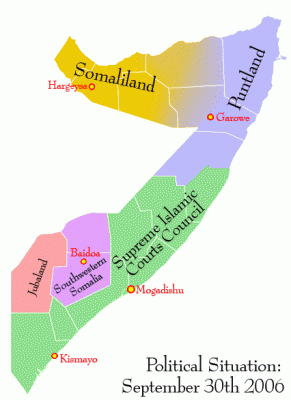
Paper Presentations:

United Caliphates of Europe: A Geographical Look at Sharia Microstates
The latter half of the twentieth century saw a large rise in Muslim migration into Western and Central Europe. Originally, Europeans assumed that only a small number of immigrants would arrive and that they would assimilate. However, the promise of Europe attracted a larger than expected number of migrants. At the same time, immigrants interpreted European promises of "human rights" to mean that cultural assimilation would not be necessary. Now original misunderstandings have led to societal conflict, and have helped create spaces where regular law enforcement is nominal at best. Not falling into anarchy, these spaces have instead become microstates under improvised Sharia law. These microstates have similar demographic, infrastructural, and spatial qualities with each other and are each a part of a larger communicative network.
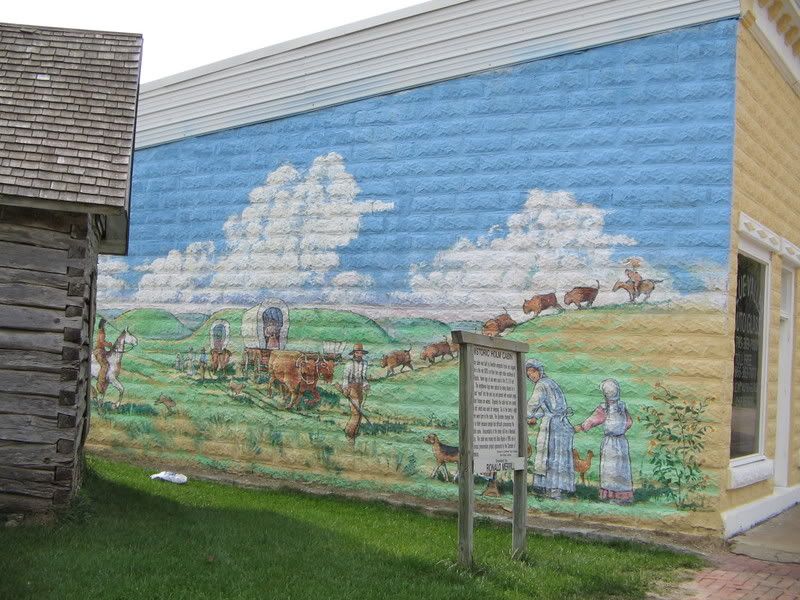
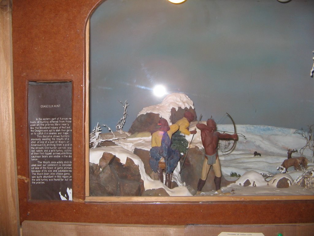
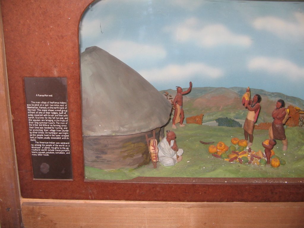
To be presented at the Association of American Geographers National Convention in San Fransisco during April 17 to 21, 2007.

Portrayals of Plains Indians and US Army along the Oregon Trail
When one thinks of the Oregon Trail, “America’s National Epic,” one thinks of brave, noble families on their own, reaping the awards of Manifest Destiny. Rugged wagon trainstraveling on the vast, empty “Great American Desert” heading off into the west. However, two key players in the national epic are commonly missing in the popular mindset: Indians and the US Army. These two groups provided safety, excitement, and danger to emigrants in the Great Plains section of the Oregon Trail. All along the Oregon Trail these groups played crucial roles in the national epic. Their portrayal along the Oregon National Historic Trail is one of accuracy, inaccuracy, and total ignorance.
Was presented at a regional meeting of the Association of American Geographers

Panel Sessions

Spread the word: Podcasting, blogging and the New Media in Geography
Podcast. Blog. These are words that continue to expand into the mainstream from their tech-based roots, and have even made their way into the dictionary. The "New Media", which includes blogs and podcasts, have become effective tools for reaching a number of audiences, including Geography and geospatial technologies communities. For members of the general public who are interested in learning more about geography-related topics, these New Media can offer a useful starting point for some and interest others in learning more. Many professionals now routinely use blogs to disseminate up-to-date information and discuss events and trends relevant to their industry. While there are still those who are not familiar with the technologies, those in the know are asking the questions "how can they help me", "what can they be used for", "who is blogging and podcasting" and "how can I make my own". The panel will offer differing perspectives on blogging and podcasting, with specific focus on the Geography and geospatial technologies communities that have emerged within the 'blogosphere.' The discussion will touch on a variety of topics including the great potential for the New Media as educational tools, but will also attempt to provide answers to the questions above and those of the attendees.
To be held at the Association of American Geographers National Convention in San Fransisco during April 17 to 21, 2007.

Lecture Presentation

How do you cite a KML file? A look at Neogeography
The first decade of the twenty-first century is one of great promise for geography. New tools like virtual globes, mash-ups, and other things have given the academic, professional, student, and common person the ability to explore and learn more about the Earth like never before. These tools and their related applications have extremely low learning curves while still being high quality. Right now some schools are using neogeography to educate while businesses and organizations are putting it to practical use. This presentation takes a look at some of the uses of neogeography and how it could possibly change the face of geography in the academic and outside world.
Possibly to be delivered at the South Dakota State Geography Convention and where ever I can present it or am invited to present (drop a line if you wish!)

Thursday, November 09, 2006

Why Geography Has Not Returned to Harvard

World War II was the high point for American geography. Geographers worked in all branches of the government and were making a difference in government policy. Almost as important was that the American public knew why geography was important. This changed almost as soon as the war was over. Other academics decried geography as mere description. This happened at Harvard when geologist Marland P. Billings successful managed to pull geography out of Harvard because it was "not a university subject."

Fast forward fifty-nine years and Harvard is celebrating claiming geography is back. The big news is the launch of the Center for Geographic Analysis. The news was greeted so widely in the academic subuniverse of geography that the Harvard Geographic Society has pretty much gone into hibernation mode as an independent group.

Catholicgauze still is not happy. By "geography" they do not mean physical geography or geography that I use to help understand the world but GIS! Catholicgauze feels GIS is a useful tool, as other disciplines are using the Center for, but too many geographers and non-geographers worship the tool as an end in and of itself. Until a respectful concentration in areas like physical and world regional geography return to Harvard Catholicgauze will moan its state at the university.

Category: GeoInfo

Wednesday, November 08, 2006

Virginia is Flordia 2.0

Oh No! Lawyers! I do not care if the Senate "hangs in the balance." Why can they not settle it the Southern way with a duel? I promise my readers there will be no American political-geography blog posts (unless geography is outlawed or something along those lines) until the Virginia mess is done. "Regular" geography will dominate once again!

Geography of the 2006 Midterm Election and What Does it Mean?

The Blowout Belt

The newest word entering the political lexicon will be "Blowout Belt." The Blowout Belt refers to the collection of states from around Rhode Island to Indiana where Republican Party lost many seats.

The Republicans lost in the Blowout Belt because of three reasons: 1) The Iraq War, while being al Qaeda's Vietnam, has been a propaganda loss for Bush's party, 2) Corruption has been following the Republican Party in House with the party paying little attention to it and 3) the Republican Party has become the party of the establishment while ignoring the small government conservative/libertarian base.

The Democratic Party won the House with because of two reasons. 1) The Democrats won in the suburbs which will be swing areas for a while. The suburbs like corruption-free, low taxes, and budget surpluses. 2) In the Great Lakes states and in the Southern states yellow dog and Clinton-style Democrats won while promising to lead from the center.

2008 could go either way. The Republicans must find a way to neutralize the Iraq issue and prove it is loyal to the base on issues like spending and border control. Democrats have two roads to go down. If they operate like Bill Clinton or Joe Lieberman they will be neigh-on-unstoppable; however, if they let leftists bloggers control issues like the War on Terrorism then Republicans will be back in a heart-beat.

On local issues it seems America is still a center-right nation (ballot issue results). Several states passed laws defining marriage as between a man and woman, medical marijuana was defeated, Michigan has passed a law limiting affirmative action, and while South Dakota did reject its abortion ban polls say that one which would allow a rape exception would pass easily so expect that bill to be back.

The 1990s saw Clinton try to rebuild a Democrat Party in disarray infected by 1960s radicalism, he succeeded in part but failed to keep his DLC in firm control. The 2000s had Bush trying to build a permanent Republican Majority but it appears that Washington's atmosphere had led the Grand Old Party astray. The future is open in Purple America.

Catholicgauze congratulates the Democrats on their win and reminds them to govern well. To Republicans Catholicgauze tells them to take the loss as grown-ups and learn their lesson.

Category: Geopolitics

Tuesday, November 07, 2006

Michigan Midterm Election Map

More election results and prediction maps

Michael Muskovin of Ottawa County, Michigan has informed me that his GIS group will have real-time election results mapped on their website. Apparently they are the only county in Michigan doing this. Congrats guys!

Weather Map on Election Day


Weather could be bad in the inner East. That could lower the last minute, swing voter turnout. This may play a role in Pennsylvania and Maryland where two tight Senate races are going on.

Election Day

Vote!

If you are one of my American readers stop reading and go vote...

I think we got rid of them. I already voted absentee and will spend the election evening with friends of all political stripes at a politics-forbidden dinner reception. I hope to have a blog post on the elections sometime Wednesday.

Usually the party in charge during a second term midterm election loses big. Can Bush buck the trend and prove he is a political genius or will Tuesday be Howard Dean's day? Will TDAXP's South Dakota become the medical marijuana smoking, abortion-free state where juries could be sued for making the "wrong" decision? Will the Catholic, pro-life, anti-gun control candidate beat the Catholic, pro-life, anti-gun control candidate (hey, wait a minute!)? All this and more will be made know sometime very soon.

Barring; of course, a repeat of Florida in 2000...

Freedom of the Press Worldwide


Let us compare Western and Eastern Political Cultures

Reporters Without Borders recently released their analysis of freedom of the press worldwide. In double cool news one can download a country-by-country breakdown for Google Earth! (Hat tip: La Cartoteca)

Countries that have a liberal, open society score on the upper end. The best places to be a reporter are apparently Ireland, Iceland, Finland, and the Netherlands (unless you want to take on the Sharia microstate, then you get murdered). On the other hand fascist, communist, and just thuggish countries have very few freedoms for their reporters. Countries joining North Korea, Turkmenistan, and Eritrea (where being a gospel singer can get you arrested) on the nasty list include the People's Republic of China, Cuba, and Burma.

Category: Miscellaneous

Monday, November 06, 2006

2006 Election Maps Part 2

Continuing finding maps of the midterm election...

MSNBC has a mash-up
based on Microsoft's virtual Earth. Push-pins provide detailed information. (Hat tip: Very Spatial).

The New York Times has a series of maps for the House, Senate, and Governorships. By clicking on the states one can get detailed information not only on the race but also of the state. It even gives how conservative or liberal the incumbent has been in the past.

FOX News will be updating their map as elections come in. Besides election results not much can be found.

Category: Maps

Sunday, November 05, 2006

Saddam found Guilty! What Next?


Saddam Hussein was found guilty for the murders at Dujail. While sounding defiant the monster was trembling.

A quick breakdown of the other little monsters:
  • Half-brother Barzan al-Tikriti has been sentenced to death.
  • Former chef judge Awad Hamed al-Bander will be joined them on the gallows.
  • Former Vice President Taha Yassin Ramadan will spend the rest of his life in jail.
  • The minor Baath Party official of the area; Mohammed Azawi Ali, has been found not guilty.

Where Iraq goes from here is up to the Iraqis. Loyal Sunnis may wish to step up and fight harder but they only make up about ten percent of the population now. There is no way they can defeat the United States militarily, only politically. The bigger threat to Iraq is Iran's proxy army- the Mahdi Army. The militia fights hard but can easily be mopped up in battle (as the Iraq videos show). For some reason the United States and Iraq are willing to bring Moqtada al-Sadr to justice in this world or the next. We have waited too long and now he is a popular figure who controls territory (a very bad thing in this era of fourth generation warfare). To avoid martyrdom it would be best if the Badr Brigade or the Iraqi government get rid of him.

However; if Iraq continues along the course of slow progress, bloody sure but still slow progress Americans may lose the will to fight and finish the job. This would leave another Afghanistan or Somalia in the world. Something we would have to return to when it is even harder to fix.

Category: War on Terrorism

Man as Above Nature

A semi-continuation of yesterday's post of humanity in nature. We will return to regular geography on Monday

One of my favorite abandoned aspects of geography has to be the teleological/cosmological study of man and the surrounding world. My scientific and religious beliefs give me a background into what once again can prove useful and help bring back geography into the mainstream.

Of the most important scientific discoveries two of them have to be the first law of thermodynamics and the rejection of spontaneous generation. The first law of thermodynamics states that matter (energy) can be neither created nor destroyed. Those who rejected spontaneous generation laid down the law saying living things can only come from other living things.

The above accepted scientific facts pose a problem; however. If matter cannot be created or destroyed where did the universe come from? The Big Bang only explains the expansion of the condensed universe spreading out over some unknown chaos. The chicken came from the egg of a proto-chicken but where did the first living cells come from? I have seen drawings which show lighting hitting somesort of primeval soup but I do not care how many times you zap dirty water, nothing is going to come out of it.

I use religion to explain these mysterious while others may choose a different route. What matters is that there is something much deeper that went on and our current concept of science cannot come close to explaining it.

Why does this all matter? Well, even though I see humans as part of nature, we clearly seem to be the main actor at the present time. For some reason we seem to be the only ones able to reason and know what is right and what is wrong. We all have the ability to mold the Earth on a massive scale. Tying this all together we have the ability (and some may say God given mandate) to be the caretakers of the world.

The field of geography with its man-land tradition is the perfect science to be home of this philosophical investigation into how man can be a better caretaker. I am not advocating abandoning the practical doings of geographers. Far from it I am just asking geographers to keep the cosmological role of man in the back of their heads as they do their real world geographical investigations. I do not call for this to be the driving philosophy like the fads of making everything quantitative or how some geographers sought to change the science through Marxist studies. Just keep my recommendations in the back of your head as the little conscience that peaks up once in a while. Even the smallest of ideas can make big changes.

Category: Cosmosgeography

Saturday, November 04, 2006

A World without Man...

If an ant colony makes a new home is the dirt mound on top natural? If a beaver builds a dam is the pond natural? If men in a construction crew landscape is the lawn natural?

Well, according to Bob Holmes the first are natural but the last one is not. In his article "Imagine Earth without people" Homes writes about how humans are separate from the natural environment and can only be viewed in a negative light. Robert McHenry counters in his "Eden Without Us?" which questions Homes' views on the placing of humans outside nature. (Hat tip: Instapundit)

I guess one of the reasons I like geography so much, and the study of the ancient geographers, is the importance of the cosmological/teleological aspect. To understand the world and the cosmos one must realize that while humans are the most powerful player (that has made itself visible) it is still just an actor in the play which is the universe. We are still made out of organs, which are made out of cells, which are made out of molecules, which are made out of atoms just like everything else we scientifically know of. To think that getting rid of a "non-natural" thing like humans will "restore" the Earth to somesort of "natural" state is childish at best and absolute stupidity at worst. Think what the world has gone through. Mass extinctions, global cooling, and global warming to such extremes that Al Gore's head would explode. My own mother, with no formal paleogeographic training, is well aware that her home state has been an inland sea, desert, rain forest, desert again, savanna, under a couple miles of ice, under a giant lake, steppe, forest, and steppe again all in the last 100 million years or so all without any input from humans.

Tomorrow Catholicgauze changes gears and looks at how humans, while still part of the natural world, are at the pinnacle

Category: Cosmosgeography

Friday, November 03, 2006

Geographic Travels to Hell on Earth

Imagine Geographic Travels with Catholicgauze!, minus Catholicgauze, and add all the places which can be best described as the worst places in the world. What do you get? Why, the Worst Places In The World, of course!

Worst Places in the World is a blog which, while rarely updated, clearly believes in quality over quantity. The blog takes a look at disastrous areas combining remote sensing, encyclopedic knowledge, and a healthy does of geographic thought. Whether it be uranium mining which makes water green can Navajos sick or warlords killing each other and anyone in between, this blog has it. Logical categories help one to navigate to various bad things on the earth. The blog is an excellent source for would-be hazard geographers.

And one a double plus note for the blog, its article on Venezuela's willful destruction of the Imataca Rainforest Preserve ("liberated by Chavez for the good of the people") backs up what I said yesterday on how nationalization of recourses by Latin America is a bad thing not only for businesses but also the environment.

Hat tip: Great Map

Thursday, November 02, 2006

Latin America Goes Backwards


The Legion of the Backwards

The economic lesson from the 1970s and 1980s was Hayek was right. In order to help an economy, a government, and the people in a country it was best to let businesses and markets be free of government control. Incidents like the British coal mining strikes and resolsed showed that while some people will be hurt by deregulation; the economy and most people are better off. (See the documentary Commanding Heights for more)

East Asia including China, Europe, and North America have successfully deregulated many industries and are stronger for it. So what does Latin America decide to do? Nationalize industries!

National Geographic has a good article on the effort by governments in South America to seize natural resources. This scares away business and investors and while it may give temporary improvements the economies will become stagnat and fail like Albania did (from 1910 backwoods to 1960s Communist power house to 1910-style backwoods in the year 2000). It is more than just the economy which is hurt but also, as National Geographic points out, the environment. Many environmental reserves are becoming the private playground and money pit for Latin America dictators and dictator-lites.

Do not think these are efforts to give resources and power to the people. Nationalization in Latin America is done by thugs who receive funds from the industries and resources instead of a shareholder. At best its robbing Peter to pay Paul, at worst it is robbing honest men to pay the Devil.

Unfortunately look for Latin America's turn backwards to continue as it bucks the rest of the world in political movement towards the center-right.

Category: Geopolitics

Wednesday, November 01, 2006

Paleogeographic GoogleEarth

Remember how cool the Paleogeographic maps of North America were? Well this comes from the same mold! GIS master Valery Hronusov has released an animated map of the continental movement for Google Earth.

The map shows the position of the continents from the Late Permian (260 Million Years Ago when the highest form of life on the earth were the proto-dinosaurs Synapsids) age up until today! Download it today and enjoy!

Catholicgauze hopes his mother well be able to enjoy this; she has always had an interest in paleogeography and was a major influence on my decision to study geography.

Hat Tip: Google Earth Blog

Category: Physical Geography