Tuesday, March 31, 2009
Map of the Main Arab Sunni Insurgency Groups and Key Areas - Spring 2009
I have created a Google Earth map showing the main Arab Sunni insurgency groups and key areas of that part of the Iraq War. The map can be download via the Google Earth Community Board.
Catholicgauze's Time in Iraq: Part II
Yesterday I answered questions concerning my time in Iraq. Now I will answer, to the best of my ability, questions concerning Iraq and related atmospherics.
Is the War Against Al Qaeda in Iraq (AQI) Won?
Some bloggers who never were in Iraq and some who were have declared victory. I meanwhile see AQI as lying on the ground, bleeding from all orifices.While near AQI is near death anyone who says they are defeated is wrong. The greater command network of AQI is destroyed so now AQI is more or less a grouping of quasi-independent regions that relay on themselves for logistical support. Right now most of the fighting against AQI is done by the Iraqi Army and Iraqi Police. These organizations still need the help Coalition Forces can supply including advanced targeting and large, overwhelming force.
Is AQI the Biggest Sunni Arab Enemy to Iraq?
Right after the invasion in 2003 it seemed that the former Baathist, Saddam regime would be the biggest problem in Iraq. It was not until 2004 when al Qaeda in Iraq became the top dog of the Sunni Arab insurgency. During 2006, 2007, and 2008 the Awakening Movement occurred as Sunni Arabs rebelled against AQI for its extremism and violent acts against Iraqis. Today, smart AQI members and cells have managed to merge with other insurgent groups to provide cover. Most of these cells have started the transformation from insurgency to general thuggery a la the American insurgent/terrorist group, the Ku Klux Klan.
A group I recommend watching out for is one some army friends told me about. The Men of the Army of al-Naqshbandia Order (JRTN). JRTN has allied itself with the former regime elements in the New Baath Party (NBP) due to NBP's leader, Izzat Ibrahim ad-Duri, being a Naqshbandi Sufi. Soldiers I talked to claim JRTN gains its legitimacy from its religious background, the fact it has former regime members in top leadership, and it does not target local Iraqis. JRTN seeks to avoid the mistake AQI made and thus become the prime Sunni Arab insurgent group. It is rumored by Iraqis that JRTN has ties to the Syrian military as well and has been able to get its hands on some serious firepower like RKG-3 grenades and anti-aircraft weaponry.
Is the Average American Fighting Man Aware of the Geographical/Historical/ Cultural Situation of Iraq?
No. The educational system and the military have failed most of the American soldiers I have met. When someone joined my geography team or worked closely with us it was my job to get them up to speed. I had a nice thirty minute talk about Iraq prepared for anyone and everyone. Everyone in uniform was eager and curious to learn. Unfortunately many had no background on the situation. I was asked by a Navy officer if al Qaeda was a "mostly Sunni" organization. Many had no idea of the differences between Sunni and Shia and why/how it mattered.
Will the War End Well?
The Coalition Forces and Iraqi Army can buy time and further dismantle the insurgent groups. In the end; however, the war's outcome is up to the Iraqi government and the Iraqi people. They themselves must move on from the past few years of slaughter and forgive past sins. Peace is in their hands... if they can all agree to it.
Monday, March 30, 2009
Catholicgauze's Time in Iraq: Part I
I am still getting use to "normal" time but blogging is helping. Right now I am working on a Google Earth product based on my Iraq experience and finishing up the questions and answers. However, here is Part I.
What Exactly is a Geographer Doing in Iraq?
Geography is a diverse science and my time in Iraq has proven that. My work involved combining elements of tribal affairs, environmental geography, and even military geography. I had the opportunity to interface with Iraqi and American authorities to aide in reconstruction efforts. My duties included using GIS to find key access points for critical infrastructure, research on certain areas, and carefully explaining that I do not have divine powers to get jobs done instantly.
Where Was I?
All my time was spent in the Sunni Arab lands of Iraq. The majority of time was in Al Anbar provience with Salah ad Din coming in second. I briefly visited Ninawa and Kirkuk provinces. Despite plans I never went to Baghdad.
Was I Ever in Danger?
Yes. The scariest moment happened on a plane ride. All the sudden my little plane was forced two drop flares and do evasive action. The fact that I was near where two helicopters crashed made me realize the dangers of northern Iraq.
What Geography Tools Did I Use?
My main tactic for information gathering were qualitative: interviews and library research. When it came to actual tools I was surprised. While ArcGIS is powerful, few computers in Iraq have it and it is complicated to the uninitiated. So Google Earth was used for presentations while FalconView was used for cartographic creations. Also, I never once used latitude and longitude. I solely worked on military grid reference system (MGRS). I started listing off MGRS like mad to the point 38-Sierra seems like home... almost.
How Was My Arabic?
My Arabic has gotten better but I dare not use it without a translator on hand. Whenever I used my Arabic it seemed like everything stopped. Iraqis are still shocked that "average" Americans try to speak Arabic. I was asked multiple times "Are you a Muslim?" by Iraqis who were shocked/impressed by an American speaking Arabic.
Did I Meet Any Iraqi Christians?
Yes. The first two I met where Christians. Most Christians are either in Baghdad or up in Ninawa province. Christians are so rare elsewhere, especially Anbar, that several time I was told about the closest Christian: "Butros" a mechanic who fixed cars and lived over four hours away. Sadly I was unable to attend any Assyrian Church of the East or Chaldean Catholic Church services.
Where Was the Worst Place I Visited?
Salah ad Din province. Period. Indirect fire plus sandstorms plus being chased by bats. Yeah.
Tomorrow: Questions and Answers About Iraq and Atmospherics
Saturday, March 28, 2009
Catholicgauze Back in the United States
What a journey! Catholicgauze is back in the United States and trying desperately to get use to "normal" time. Working up to twenty hours a day can make a body not use to the need of sleep. Currently I have about a dozen hours a sleep in the last three days and I feel fine... ready to crash... but fine. Blogging will continue on Monday with Tuesday being the day I answer questions I received.
Friday, March 27, 2009
Google Earth Map of National Geographic Grants
Many people think the National Geographic Society just makes the famous magazine. However, a percentage of each subscription and gifted money goes to grants that National Geographic gives out for studies around the world. Now one can download a Google Earth KML and view a map of thousands of grants the society has awarded. (Hat Tip: Google Earth Library)
Thursday, March 26, 2009
Bluewalks: Neogeography Meets Walking Tourism
La Cartoteca proves once again why it is Catholicgauze's favorite Spanish-language blog by discovering Bluewalks. Bluewalks is an online collaborative flight which asks users to create and share their favorite walking paths for tourists. The mapping system is based on Google Maps so it is easy for almost everyone to create, share, and view the maps. Currently a good deal of Europe, some of the United States, and elsewhere have been mapped. The four languages of Bluewalks are English, Chinese, Spanish, and Catalan.
I greatly enjoy walking as it allows one to be outside in the environment and gives amble time to absorb one's surroundings. Traveling in an enclosed place such as a car cannot give this feeling. Because of this when I travel I like to see the sites by walking.
When I get back to the United States I will be sure to make a couple of these maps and share it with the rest of you.
Wednesday, March 25, 2009
Using Google Earth to Teach Geography
The great Geolounge blog links to a phenomenal educational plan entitled "Teaching with Google Earth." The site features introductions to Google Earth, KML, API, and more. The real core of the teaching aide are the various activities. Activities range from river characteristics to Richmond's heat island to the 2004 tsunami. There is something for every physical geography teacher to use.
I have long felt Google Earth had the potiential to be a great learning tool. As more tools and resources are made readily available for teachers I am sure more educators will take advantage of the situation. Google Earth is "cool" to children and young adults. This makes it the pefect gateway drug into the field of geography.
I have long felt Google Earth had the potiential to be a great learning tool. As more tools and resources are made readily available for teachers I am sure more educators will take advantage of the situation. Google Earth is "cool" to children and young adults. This makes it the pefect gateway drug into the field of geography.
Tuesday, March 24, 2009
DVD and Blu-Ray Region Codes
Funny but true story: President Obama gave Prime Minister Gordon Brown twenty-five DVDs as a symbol of the special relationship between the United States and the United Kingdom. A geography fail occurred when Prime Minister Brown found out the hard way that the DVDs are not playable in the United Kingdom.
Region codes were invited to control where moves were distributed so the film companies could maximize profits and releases using economical geography. There are nine codes for DVDs. Strange Maps has a map of the six geographical zones. The other zones include 0 (works in any DVD player), 7 (screener copies of DVDs, invented to fight Chinese movie piracy), and 8 (international venues like airplanes, cruse ships, etc). Most computer DVD-viewing software can play any region while hacking is necessary to reformat one's DVD player to be region free.
A: East Asia and North America sans French Guiana
B: Middle East, Europe, Africa, Australia, and New Zealand
C: Russia, People's Republic of China, India and a few others

Blu-Ray Regions
Sadly, HD-DVD, now discontinued, was region free. So in the future international tourists, and international leaders, will still have to be conscience of regions when they buy or gift movies and video games.
Region codes were invited to control where moves were distributed so the film companies could maximize profits and releases using economical geography. There are nine codes for DVDs. Strange Maps has a map of the six geographical zones. The other zones include 0 (works in any DVD player), 7 (screener copies of DVDs, invented to fight Chinese movie piracy), and 8 (international venues like airplanes, cruse ships, etc). Most computer DVD-viewing software can play any region while hacking is necessary to reformat one's DVD player to be region free.
The HD-DVD versus Blu-Ray war is over and the victor, Blu-Ray, is currently changing the geography of movie players. Blu-Ray has three regions.
B: Middle East, Europe, Africa, Australia, and New Zealand
C: Russia, People's Republic of China, India and a few others

Blu-Ray Regions
Monday, March 23, 2009
The United Nation's Flawed Effort to Decriminalize Homosexuality

Map showing where homosexuality is punishable by death, where it is outlawed, and selected members of the United Nations Human Rights Council (Click to Enlarge)
President Barack Obama has come out in favor of human rights by pledging to support a United Nation's statement calling for the decriminalization of homosexuality. The proposed statement stays away from Western-world controversial issues like civil unions and instead focuses on decriminalization.
Unfortunately this statement, if it can pass despite fierce opposition, will mean nothing. The main supporters of the bill are European Union members and the United States. The west began abolishing anti-homosexual laws starting with revolutionary France in 1791. The homosexual debate has transformed away from basic human rights to other matters. The places where homosexuality is where the statement is being opposed and where the statement will be ultimately ignored by the respective governments.
The one place where human rights reform might have a chance in the United Nations is the United Nations Human Rights Council (UNHRC). Sadly this is not a friendly place for those who wish to decriminalize homosexuality. Nearly a third of all UNHRC member countries outlaw homosexuality with two member states, Nigeria and Saudi Arabia, authorizing the death penalty for homosexuality. So the council has only specifically denounced Israel for human rights violations and has focused over half its time on Israel alone. The fact a large section of council supports continued criminalization (the president of the council is from Nigeria which has the death penalty for the "crime") makes it clear the United Nations does not take all rights seriously.
Until violations of human rights is taken seriously by the United Nations nothing will change. Western countries will continue to push for statements calling for expansion of Western/liberal ideas and these countries will feel good about their actions. Meanwhile, homosexuals, ethnic minorities, religious minorities, and others will continue to be arrested and executed in the streets by their oppressive governments. It will be like nothing happened.
Sunday, March 22, 2009
Preparing to Come Home
My time in Iraq is almost done. I have officially handed over my position though I will still come into work for short periods of time. Power issues have forced me out of my can, a third divided into three rooms with one person in each room. I have moved to the outskirts of a base into a former Iraqi Army office building which was turned into a gym by Coalition Forces but more or less abandoned late last year. Besides a gym and the sixty or so empty beds I found a 72" television, an X-Box 360, and internet to occupy myself. Until then I sit and wait to go back to the United States.
Saturday, March 21, 2009
My Wonderful World Has Upgraded
National Geographic's My Wonderful World blog has improved its blog since I have been deployed. Besides the new look and fell, the My Wonderful World team hopes to have more frequent and deeper depth for their posts. What interests me the most is their effort to increase participation. I want to know if this works out. Get participation on blogs is notoriously difficult. So I hope My Wonderful World can find content that can produce feedback (educational plans or current topics probably are the best route).
Friday, March 20, 2009
Ancient and Medieval Christian Fundamentalist Geography Explained
Biology education in the United States and elsewhere has been turned into a battleground between evolutionists and Biblical/Qu'ranic creationists. As this battle goes on most may think that Geography is thankfully not involved in it (besides Geomorphology and our brother science Geology). This has not always been the case. The above video, done as a training tool for Christian educators, shows how Geography was once a battleground.
It may seem hard to believe but the existence of antipodes, lands outside the knowledge of Eurasia, was once thought as heretical. How could God create lands and people who never had a chance to hear the Gospel? Great thinkers such as Saint Augustine dismissed any possibility of undiscovered lands. When new lands were discovered, this erroneous thought had unfortunate consequences. A few thought the natives of the New World could not be people because they had no chance of hearing the Gospel. So instead some labeled the natives as Pre-Adamites who were no better than animals and deserving of no special treatment. While groups like the Jesuits worked for humane treatment of the newly colonized people the damage was already done.
The video's second half deals with why Nicolaus Copernicus and Galileo Galilei's belief of Heliocentrism was so controversial. The Roman Catholic and Protestant churches were concerned about Biblical passages that had the stars and sun move or stop and not the Earth. Greek thought about the heavens being perfect and separate from the Earth, viewed as fallen in Christianity, were also critically at stake.
Today the current physical geography of the world is not in question except by a few nuts. Meanwhile geographers can just sit back and watch the biology debate rage on.
Thursday, March 19, 2009
iRevolution: A Blog About Using Information and Neogeography for Changing the World
iRevolution is an academic blog by a doctoral research fellow at Harvard Humanitarian Initiative in Harvard University. The blogger behind the site is primarily interested in how regimes use information to control a populace and how the information revolution has empowered individuals. While this may not seem geographical at first, he repeatedly points out how geographical software tools allows researchers to study spatial inequalities, places of repression, and better map out crises.
The post on crisis mapping background gives one a good understanding of how neogeography relates to the information revolution. The post on new tactics for civil rights describes how neogeography and information technology combine on a local level for political activism around the world.
What first got my attention was his post on my Russia-Georgia War maps. He liked them but pointed out that I was only one person and a better way to have a crisis map would be to have on the ground sources. Interestingly enough, al Jezeera had a crisis map which used on the ground input from viewers.
Wednesday, March 18, 2009
Sri Lankan-Tamil Tiger War Map
Wars have a way of bringing out the (neo)geographers in everyone. The Russian-Georgian War inspired me to create Google Map of the war's progress while Al Jezeera took the lead for the 2008-09 Israeli-Hamas War and asked viewers for on the ground intelligence.
Now we have a government getting involved. The Ministry of Defence, Public Security, Law & Order of Sri Lanka has created the Battle Progress Map showing the probable final fall of the Tamil Tigers (Hat tip: La Cartoteca). The map is a fine piece of work featuring toggable layers, fancy graphics, photographs and videos, and time lapses of the war's shift into the end game.
Now we have a government getting involved. The Ministry of Defence, Public Security, Law & Order of Sri Lanka has created the Battle Progress Map showing the probable final fall of the Tamil Tigers (Hat tip: La Cartoteca). The map is a fine piece of work featuring toggable layers, fancy graphics, photographs and videos, and time lapses of the war's shift into the end game.
Monday, March 16, 2009
Iraqi Dinars: How Saddam Turned Back the Clock

Pre-Saddam Dinars (same design on a current Iraqi dinar top) showed industrial progress while Saddam-era Dinars emphasized the past
Two of the neatest postcards I have sent back to my family are of Iraqi dinars from the 1970s and 1990s. When I bought the postcards I quickly noticed two key differences. The 1990s money postcard had Saddam's image along with glorified images from Arab and Iraqi history. The pre-Saddam 1970s dinars lacked any leader's image and displayed symbols of progress like ports, dams, and factories. After talking to Iraqis and others it became clear how Saddam turned Iraq's clock back. Saddam's actions are striking when compared to neighboring Syria which is ruled by a fellow Baathist.
The Baath Party movement was started by a Syrian Greek Orthodox named Michel Aflaq. The movement's goal was the unification of all Arabs under one state and the removal of outside colonial powers in the region. Domestically it is socialist and its anti-democratic stance combines elements of Hitler and Stalin. At first its followers were primarily in the military or intellectual class, this included a large number of Christian Arabs. Baathism quickly became popular along with the greater pan-Arab movement led by the Egyptian President Gamel Nassar. In the 1960s the Baath Party managed to seize power in Syria and Iraq.
At first both the Syrian and Iraqi Baath parties emphasized progress. Women's rights were expanded, industry developed, secularization enforced with the abolition of many Sharia laws and protections for minorities beliefs like Christianity (Jews though still suffered through periods of persecution because of strong anti-Israel sentiments).
Syria developed a cult of personality based around its leader Hafez al-Assad. Hafez made sure that he was tied into the nation's progress. Assad's son and successor, Bashar, has been unable to keep the same level of personality cult alive. He has somewhat accepted this fact. Today his main push to show how he is the node that connects the past and the future together. This is demonstrated on the Syrian Pound which has images of Syria's past and present on them.
Iraq's managed to avoid a leadership cult until the 1980s when Saddam managed to prove his permanence. Before that Iraqi money lacked any leader's image and had images of modernization. When Saddam's cult flourished images of the leader appeared with Arab horsemen, ziggurats, and alike. Saddam kept Baathist secularization in place until the Iraqi defeat during the 1991 Gulf War. After that "God is Great" was added to the Iraqi flag and persecution of Iraqi Christians began in the north. As the sanctions impacted Iraq more and more, the personality cult increased and Baathist-led progress decreased. Women still had rights but Saddam emphasized the role of men as leaders of the family, women began wearing head scarves more, and Iraq began to scale back scientific, liberal education.
When Saddam was deposed the new Iraqi dinars were a combination of de-Saddamed and pre-Saddam dinar designs. Today Iraqi dinars follow the example of the Syrian pound by having both historic and present-day images.
A great learning exercise to study foreign currencies. What is on their bills? Draw conclusions about each country based on their money and then study the country to see if you are correct.
Sunday, March 15, 2009
Hotel Camp Fallujah: The Anthem of Those in Iraq
Note: A somewhat skimish scene occurs after the line "No shower shoes outside your trailer." Looking away is advised for senesitive audience members.
Hotel Camp Fallujah is a parody of the famous Hotel California by The Eagles. Hotel Camp Fallujah is half-joke, half-lament on the flux which enters the lives of those deployed. The song describes the dangers, loneliness, spoiled self-importance, and weirdness who operate on a forward operation base. The lyrics below are on version of the song. The meanings are explained after the lyrics.
On this crap desert highway, hot wind in my face
Everything smells just like low-tide, garbage all over the place
Up ahead in the distance, a dead donkey eaten by dogs
I swear there’s a wire coming out of its butt leading over behind some logs
IDF at the CMOC, the Muj at the FDC
Giving chocolate to the children, then getting hit by an IED
And the freedom bird for re-deployments so far away
Wake me up it’s the same old thing, it’s Ground Hog’s Day
(Chorus)
Welcome to the Hotel Camp Fallujah
We’re in Iraq again, but it’s garrison
We’re livin it up at the Hotel Camp Fallujah
Said we’ll bring the fight, don’t turn on bright light
There she stood in the doorway, but you know she can’t come in
Someone shit in the shower, with Camp Grizzly Gestapo you can’t win
Salsa night just got cancelled, no boys and girls can’t touch
They took away the Coor’s Cutter too, I think that’s a bit much
Can’t buy clothes at the PX, everything’s extra-large
Can’t get by the Ugandans, they’re the ones charge here in-
No shower shoes outside your trailer, or get crotch-rot on your feet
No lobster tails at the DFAC-2, what the hell am I supposed to eat
(Chorus)
Welcome to the Hotel Camp Fallujah
Go get your groove on, in the porta-john
There’s plenty to do at the Hotel Camp Fallujah
We’re in a combat zone, go get your ice cream cone
My mind must be terribly twisted, is she a nine or a ten
But we all know when she’ll be back to a three when we get back to the states
Wait in line to check email, you shant log in to My-space
Send that guy to the corpsman, he’s got some fungus on his face.
The first paragraph is fairly self-explanatory. Iraq is a third world country and sanitation is severely lacking. Seeing dead animals on the road side in the same spot for days is not uncommon. Terrorists have used this to their advantage by planting IEDs into the carcases on road kill.
IDF is indirect fire, most of the time being mortar fire. Most bases are away from Iraqi population centers so gun fire and grenades are out of the question. But the large ex-military population with plenty of arms floating around has allowed al Qaeda in Iraq, Mahdi Army, and others to have mortar or rocket teams that will periodically fire randomly at bases. IDF is a daily event for some bases.
Muj is slang for "Mujahideen" and its singular form "Mujahid" meaning "holy warrior." The more religious-bent insurgents call themselves mujahideen because they believe they are fighting a jihad against the "Americans, Zionist, Christians, and the apostate Iraqi government." The American military has unfortunately continues to call many of these groups mujahideen when communicating to Iraqis. In the end the military is saying "We are here to fight God's Holy Warriors." Iraqis meanwhile call the Muj terms like scum or criminals.
The freedom bird for redeployment is the flight one takes back to return to the United States.
The line "Don't turn on bright lights" comes from signs on bases like Balad and others which are frequently targets of indirect fire. Insurgent teams will look for light to train the sights on.
Men and women work together on bases and many times sleep in rooms next to each other. However, the Army and Marines have rules about the opposite gender entering in one's room. Local military police, with little better to do, enforce this rule with a passion.
Ugandans form a large group of foreigners on many bases. They are used as private contractors who man the various base checkpoints so military personnel may be used elsewhere. According to the Christian Science Monitor there are about 10,000 Ugandans serving in Iraq. This makes Uganda the second biggest deployer to Iraq with almost two and a half more people serving than the United Kingdom.
Yes, Wednesday or Friday nights at some bases really are steak and lobster night. Ice cream is also available on many of the permanent bases.
There is a saying called "desert beauty" that men claim affects their judgment of women when deployed to Iraq or elsewhere. On a military base the ratio of men to women can be between 50:1 or even higher. In time men will claim any woman will start to look good. This leads to the desert beauty effect where men will inflate how attractive a woman is.
Saturday, March 14, 2009
Akhalgori or Leningori? The Near Abroad's Love of the Soviet Union versus Russian Nationalism
Geography at About links to a news story on how there is another wave of renaming Russian cities is going on. Cities like Saint Petersburg (Leningrad) quickly shed their Soviet imposed names after the fall of the USSR. Now cities like Kirov (formerly Vyatka) are debating whether or not it should return to its original name.
The primary pushers of this movement are nationalists and regionalists. Organizations like the Russian Orthodox Church have redeemed the Imperial Age in the eyes of the people. The corruption of the Tsars is ignored while the focus is shifted to Russia's dual nature as a continuation of Rome/Byzantium while being uniquely Eurasian. Nationalists compare this vision of the past to the imposed universalist vision of the Soviet Union. Regionalists have also made peace with popular culture by emphasizing their own region's culture as part of the salad bowl which is the Russian Federation.
Meanwhile, in the former Soviet Union national states like Ukraine, Estonia, and Georgia (the Near Abroad) the opposite is occurring. Ethnic Russians and their allies are the ones who feel they are losing out from the cultural landscape changes. High levels of nationalism by the post-Soviet states have caused many ethnic Russians to have nostalgia for the Soviet past where Russia and everything Russian was "first among equals." Ethnic Russian cities in Ukraine celebrate "Red Army and Navy Day" instead "Defender of the Fatherland Day." Ethnic Russians in Estonia riot when the Estonian government removes a statue of a Red Army solider from the main square.
The biggest landscape battle though to restore the old Soviet mindset is in the breakaway Georgian republic of South Ossetia. The city of Akhalgori was in the former Soviet Georgian oblast of South Ossetia. When Georgia was becoming independent the city was transferred out of the region. South Ossetian rebels claimed it as part of their country but where unable to take the majority-Georgian but mixed city. However, in the 2008 war the city was taken by a combined force of Russian and South Ossetian forces.
Ossetians see themselves as a smaller but equal partner to Russians. I once attended a fascinating lecture on Ossetians which describes how they see themselves as a younger brother to the Russians. Throughout history this has played with Ossetia eagerly joining the Russian Empire, supporting the Soviet Union during World War II when the Germans were recruiting minorities, and by staying in the Russian federation after the USSR's collapse. Monuments and memorials in North and South Ossetia demonstrate this relationship as well. Today the South Ossetian government continues the relationship by calling Akhalgori by its Soviet Name, Leningori.
The reason for this phenomenon is fairly straight forward. In what I call the Rule of Nationalism distance decay is reversed. Nationalism becomes more intense along the frontiers and away from the hubs. Ethnic Russians and their allies outside of the Russian Federation feel threatened by encroaching cultures. Inside Russia, Russian culture is not threatened so people seek to identify themselves via regionalism. People like the President of Chechnya and Tatarstan have managed to hold onto power by playing up regionalism while pledging loyalty to the Kremlin. This has prevented regionalism in Russia from threatening Moscow and has allowed regionalism to bloom in the Putin era.
Tuesday, March 10, 2009
Abraham's Oasis

Abraham's Oasis
First, a little geography. The oasis is about six miles (ten kilometers) away from the Euphrates River. At this point on, the more northwest one goes along the river the deeper it sinks into cliff sides, making side stops difficult. The whole western portion of Iraq is desert making any access to a rest area with water extremely valuable. Finally, the oasis is last oasis of any importance until well after the Syrian border.
All these factors lead locals to claim Abraham visited the Oasis during his divinely inspired mission to the Holy Land. Despite the fact neither the Bible or Qu'ran mention any stops, if the oasis in existence he would have most likely stopped there (map of possible journey route).
The oasis is located near Al Asad Airbase. During Operation Iraqi Freedom, Australian soliders found the oasis full of Iraqi military trash. Locals were uninterested in visiting it or cleaning it up. In 2006 the United States Marine Corps ordered the oasis cleaned up. Today the oasis is guarded by the Iraqi Army. Americans or other foriegners must be guided by a chaplin when visiting the oasis (there are no athesits in foxholes and apparently no seperation of Church and State either).
The oasis is a calming place. One can close their eyes and think about Abraham and his family getting ready for the push into the desert.
Monday, March 09, 2009
Classic Gauze: Oregon Trail Game
My thesis focused on monuments along the Oregon Trail. It was in part inspired by my life long love of the trail. Oregon Trail was the first real computer game I played and Oregon Trail II was the first game my family purchased. So let us celebrate my neigh-arrival from Iraq with the Oregon Trail game!
-----------------------------------------------------------------
Originally published July 22, 2006
-----------------------------------------------------------------
Originally published July 22, 2006
This post is dedicated to some of my friends who have never played "
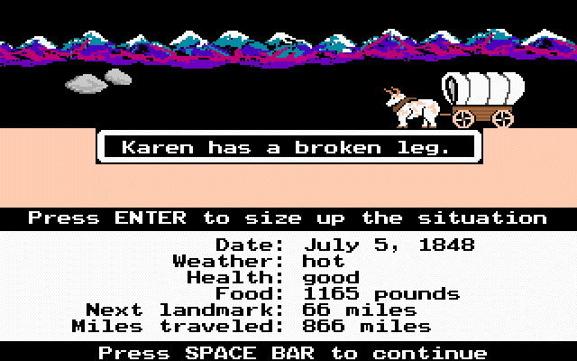
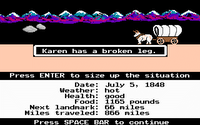
835 miles to go Karen, suck it up!
Oregon Trail has a cult following in my generation. It was the game to play beating out others like Wolfenstein 3D (I remember when my computer teacher gave us all copies), Secret Weapons of the Luftwaffe, and even Life and Death! Many others like Gamespot and Gamespy consider the game one of the greatest ever made. I agree with them.
The purpose of the original Oregon Trail game was to journey from
I learned about many sites along the trail from this game. The game is also my inspiration for my current study of the trail. It is a worthy addition to any educational program involving United States History.
The highlight of the series was
Afterwards three more
The deluxe edition (colorful graphics) can be download here. Enjoy and have fun with the tombstones!
Friday, March 06, 2009
Monday, March 02, 2009
Classic Gauze: Waltzing Matilda
Waltzing Matilda is a classic Australian song. The song represents Australia rural roots while showing the classic contempt of authority and desire to be free that is the traditional nature of the Commonwealth.
--------------------------------------------------------------------------
Originally published April 4, 2007
Waltzing Matilda is the song of Australia. While not the official nation anthem it is the song which can stir up patriotic feelings in any Australian.
The song is one of the rural nature of Australia. It describes one labor giving up everything to remain free. This appeals to many Australians who take pride in the rogue past of the island nation. The villains in the song are the land owner and the police who seek to limit the labor's freedom of movement and action.
The song has several versions of lyrics. One of the most common versions come from the Waltzing Matilda Centre. (To listen to another version go to the Centre's song page)
Oh there was once a swagman camped in the billabongs,
Under the shade of a Coolibah tree;
And he sang as he looked at the old billy boiling,
'Who'll come a-waltzing Matilda with me.'
CHORUS:
Who'll come a-waltzing Matilda, my darling,
Who'll come a-waltzing Matilda with me.
Waltzing Matilda and leading a water-bag,
Who'll come a-waltzing Matilda with me.
Up came the jumbuck to drink at the waterhole,
Up jumped the swagman and grabbed him in glee;
And he sang as he put him away in his tucker-bag,
'You'll come a-waltzing Matilda with me.'
CHORUS
Up came the squatter a-riding his thoroughbred;
Up came policemen - one, two and three.
'Whose is the jumbuck you've got in the tucker bag?
You'll come a-waltzing Matilda with we.'
CHORUS
Up sprang the swagman and jumped in the waterhole,
Drowning himself by the Coolibah tree;
And his voice can be heard as it sings in the billabongs,
'Who'll come a-waltzing Matilda with me?'
CHORUS
The use of Australian words ties the song with Australian culture. However, to many non-Australians the words can muddle the meaning.- A swagman was a laborer who wandered from town to town across Australia looking for work.
- A billabong is an oxbow lake. It litterally means "dead creek." The term billabong is now used as a brand ware of swimware which plays up its Australian roots.
- Waltzing Matilda means to wander around looking for work while wearing a Matilda, a bag to keep all of one's possessions.
- Jumbuck is slang for a sheep. It comes from the Aborigines who thought sheep looked like clouds with a similar name. Now days the Jumbuck name is used as an Australian-based moblie phone service company and a popular car in Australia.
- Tucker bag is a bag for food
- The Squatter had legal rights to randomly squat on land in Australia. He uses troopers, police, to enforce this right to limit land use. Even today land seizures are controversial in Australia. In the Men at Work music video "Down Under" squatters are shown as killing Australians right to roam.
- The Coolibah tree is a type of Eucalyptus tree. Coolibah is also a the name of a wine made in Australia.
Subscribe to:
Posts (Atom)