Sacha Baron Cohen is earning the attention he is getting.
For the past few years Cohen has portrayed Borat, a fictional Kazak journalist. Borat frequently depicts
With the President of Kazakhstan visiting President Bush "Borat" found an opportunity for free press. He was turned away from the White House while being followed by numerous reporters.
Roman Vasilenko, Press Secretary of Kazakhstan, is fighting a war of words against Borat. In response; "Borat" told reporters, "There is a man name Roman Vasilenko who is claiming to be Press Secretary of Kazakhstan. Please do not listen this man, he is Uzbek imposter, and is currently being hunted by our agents. "
Will
Category: Miscellaneous
Saturday, September 30, 2006
The Glorious Nation of Kazakhstan versus Borat
Friday, September 29, 2006
This is why I have problems with Al Gore and other "environmentalists"
Fresh off the Robert Christopherson incident Al Gore opens his mouth. Gore has claimed smoke from cigarettes is a "significant contributor to global warming." If the bad habit is a significant contributor then what the heck are cars and factories?
To all my fellow environmentalists and nature lovers: The reason there is so much disarray is because of people like Gore who make idiot claims with little to no science backing them up. I love the environment and nature. But let us study and protect it with a little less idiocy and dogmatic-style and a little more reason.
Category: Physical Geography
Robert Christopherson hates me!
Maybe that is a stretch, but it is close
Doctor Robert Christopherson is the author of Geosystems, a popular physical geography textbook, and professor at American River College, one of the largest community colleges in
Christopherson gave a guest lecture on global warming and how it is human caused. He stated there is consensus among the scientific community that global warming is human caused. He gave evidence and projections that were higher than what Al Gore predicted in An Inconvenient Truth (a work which has been attacked by some). He capped off his presentation by saying the economy would make more money if the United States adopted the Kyoto Treaty (very, very, very questionable to say the least).
Now long time readers will know I am a fan the works of Harm de Blij and others who, while believing in climate change, question how bad it will be and whether or not humans are influencing it in any meaningful way. So I decided to ask what Christopherson thought of The Skeptical Environmentalist by Bjorn Lomborg and tie that into climate cycles. Lomborg scientifically questioned how things really are and proposed cost-benefit analysis on if things should be done concerning some environmental issues.
This is what happened:
Robert Christopherson: Are there any questions?
Catholicgauze: "Thank you for your speech. Are you familiar with Bjorn Lomborg's The Skeptical Environmentalist..."
RC: Interrupting "That is not science! That is not SCIENCE!" "I am doing science. We should stick to discussing science!" RC went on to say that Lomborg should be studying RC's work and about two minutes into his rant said, "Lomborg should talk to the half-starving polar bears!"
At the end Christopherson implied he would wish to continue our "conversation" later but the people sitting next to me just looked at me with stunned faces from the vicious beat down that just went down. To top everything off Christopherson then ended the question session. There was only question asked- mine. I was quickly rushed by Ph.D. and Master students who wished to know what the background of the question was. "What did you DO!?!?" and "Do you think he's mad?" (sarcastically) were some things I was asked. A student told me he wanted to ask about extraterra global warming (global warming on other planets) but told me that even if Christopherson did not end the question session he would not have asked the question because of Christopherson's attitude.
Is this science? When a side is denounced as not being science (Lomborg has been dealt worse: he is a victim of multiple threats of lawsuit) and those who have questions are met with domineering and intimidating responses: are we not close to those who imprisoned the scientists of old?
Note: Robert Christopher blames "the oil companies" for creating "false images" and "spin" portraying the scientific community as not a unified field believing in human caused global warming. He enjoys flying, boating, driving, and other uses of fossil fuels to travel to the North and South Pole. He uses a computer (do not even get me started how computers ruin the earth) and his textbooks are printed on paper. To reach his speaking destination he took a plane to the airport and then drove quite a distance. He blames global warming not on himself but solely on "the guy going 85 on the interstate getting 8 miles per gallon."
Category: Miscellaneous
Thursday, September 28, 2006
Controversy about European Union Regional Maps
"The Daily Mail and British Conservatives have their knickers in a twist over maps from Interreg III, an EU initiative designed to foster “cross-border, transnational and interregional cooperation.” The Interreg maps — available here as PDF files — overlap one another and indicate regional, trans-border affinities, but that doesn’t stop the Mail and the Tories from fulminating against European attempts to wipe out national borders (lumping Kent with France and east England with Scandinavia) and create a European property tax. Via MapHist."
Euroskeptics in the United Kingdom do not consider the isles as part of Europe. Anyone or thing that says otherwise and tries to wear down British nationalism meets stiff opposition.
Wednesday, September 27, 2006
Bolivia Headed Towards Civil War?
Earlier this year the people in Santa Cruz voted for greater autonomy. Their complaints were that Morales was damaging the local economy by Marxist economics and he was turning himself into a dictator. To show the people of Santa Cruz how mistaken they are Morales has installed road blocks and is forming loyalty militias in Santa Cruz.
It is getting so bad that the Argentine foreign ministry has predicted there is a 56% chance of civil war soon (but not 57%...). Civil Wars are getting more common as the world reaches another turning point. Supporters and nay-sayers of the United States are watching if America can hold the Middle East and global dominance. Its a battle between republicans and a league of tyrants. Hopefully good can win while avoiding becoming a Chimerica.
Publius Pundit is blogging about the situation and is a great place for updates.
Category: Geopolitics
Tuesday, September 26, 2006
Stunning Mountain Photographs

National Geographic has announced its winners of the Banff Mountain Photography Competition. The winners deserve their title. It is more than just photographs of mountains; it is that plus photographs taken in mountainous areas. Check it out for yourself.
Monday, September 25, 2006
The Old New World Order

Remember when Catholicgauze had his crazy cartographic dream about redrawing the Middle East? Well, in 1941 Maurice Gomberg did something even wilder: he redrew the world and gave detail plans about how the "New World Order" would look.
Sun Bin already has made some key notes so I will point out the more interesting parts. Be sure to check out his blog to download the hi-res version of the map.
North America becomes a protectorate with the "option" of becoming an equal member of the
The
"Hebrewland" is established in Transjordan with land on both banks of the river
We Allies apparently had no trouble with the concept of ethnic cleansing. Systematic genocide was also cool with us as "a Population Control Policy shall be applied" in the loser countries to "reduce the numerical power" of the ex-Axis nations.
Foreign businesses and resources are nationalized according to the plan. This was made during the days of Keynesism and before people realized that planned captialism only works in the short term.
The Roma and Kurds still lose.
Just imagine this world. With all of Eastern and the most industrialized parts of
Category: Historical Geography
Sunday, September 24, 2006
Representations of Indians and US Army along the Oregon Trail: Outside of Saint Marys
After leaving the Saint Marys Mission the Oregon Trail began to divert away from the
Right outside of Saint Marys is a sign advertising the excellent pay station. The sign has an Indian chief with a fancy headdress on, a prairie-style headdress. It was a disappointment to see that the historical society which made a great and accurate museum put up a horribly off sign.
Near the town of 
Diverting off Highway 24 will take one to the Vieux family graveyard. Near the cemetery is a sign by the Pottawatomie County Highway Department which gives a slightly different view of Vieux. While mentioning he was of Indian and French ancestry, it is worded very carefully to make him and the tribe operate on different parallels. Going up the hill one gets to his actual grave. Only here does it say he was a chief of the tribe, and only on his grave marker from 1872. However, the iconography of the various graves makes it clear he was Catholic. The synergy is perfectly captured. I theorize that the Potawatomi who said "being Indian was worse than being black" was and still is to a partial extent still correct. The sign made by the local county was most distant to the truth of Vieux's role while only his family and then the state sign could give a more realistic depiction of who exactly he was.
Near the grave of Vieux and his family are the graves of 49ers that died from the cholera outbreak. The stones are worn but still present. A sign gives a quick breakdown of what happened. Only the emigrants are mentioned and nothing concerning Uniontown is present. Indians are mentioned as conducting raids along the trail in general.
Continuing to walk from the 49er graves one crosses the
The last thing to see outside of Saints Marys is the
The node of Saint Marys is behind us. The last hour or two of
Category: Oregon Trail
Saturday, September 23, 2006
The New Iron Curtin
Both Chirol at Coming Anarchy and Radio Free Europe are discussing Russia's plan for regional dominance. In short, Russia seeks to destabilize its eastern neighbors with the belief that unstable neighbors will rely on Russia for help and be unable to join the European Union and NATO. A dastardly plan, indeed.
In an era where the West and Russia should team up to stabilize the unstable arcs of the world, Russia is playing for short-term gains at the cost of other nations.
Category: Geopolitics
Friday, September 22, 2006
A Geographical Travel from Pole to Pole
While still in the planning phases; Catholicgauze is very interested. (Hat tip: Radical Geography)
Thursday, September 21, 2006
Anousheh Ansari in Space!

Anousheh Ansari: the first female space tourist, the first female Muslim space goer, and the first Iranian astronaut is in space!
She has her own blog where she is documenting her journey. She also has a flickr site with plenty more pictures. In her native Iran reaction is mixed with some cheering her on as a role model for younger children and women; while others are upset a woman is doing something productive. Catholicgauze says: GOD SPEED!
Category: Space
Wednesday, September 20, 2006
Ice Age Britain was a site of many human failures
Be sure to read the hyperlinks as National Geographic provides fascinating details.
Category: Historical Geography
Tuesday, September 19, 2006
Geography and Being Single in America
Meanwhile, MSN gives the top cities for singles to date in the United States. Catholicgauze recommends Washington D.C. The reason is because the city is filled with people who were at Boys/Girls State while they should have been dating in high school. By just wearing my red Washington Nationals cap I meet a staffer who was "interesting" and we will leave it at that.
Category: Miscellaneous
Monday, September 18, 2006
Right seizes control of Sweden
As I have been saying for a while now, the political right continues its victory march across the world sans Latin America (things are reaching breaking out however between democrats and Castro-lites in places like
The Moderate, Center, Liberal, and Christian Democrats earned 48% of the vote will the Social Democrats and their Left allies only garnered 41%. The victors vow to shift from welfare handouts to job creation.
Category: Geopolitics
Sunday, September 17, 2006
The Latest Unrest in the Muslim World
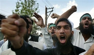 "Dear Pope Benedict XVI, I humbly request that you rescind your statement as my contemporaries and I do not believe that it would help relations between our religions. Yours truly, Amad Ibn-Battusa"
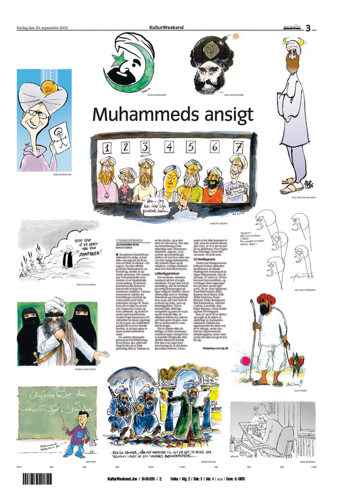 Last time these cartoons were seen people died (all Muslims killed by other Muslims)
This is a big deal. As long as the West is dependent on oil there are economic concerns. There are also humanitarian and historic reasons to be involved with the area. When the gap goes nuts the whole world feels it. I honestly do not know what can be done. Any outside reform would meet more violence then what we are seeing now. Any inside reform faces extreme opposition from Islamic conservatives and the fact Muhammad made Islam almost reform proof. By saying Muhammad was the last prophet and declaring the Koran the final word on religion no Martin Luther can change things.
In a discussion with some Ph.Ds, the academics made it clear the Muslims were being provoked. However, you do not see Catholics attacking, murdering, and terrorizing everyone else when things like Battle Pope are seen (I actually think that is sort of funny, sort of). When the Virgin Mary and Jesus are mocked with things like "Piss Jesus" or "Dung Mary", I just think "jerks" and go on my merry way. When Madonna does her thing, there were protests but that was it. We do not write books calling for and dramatizing assassinations.
So I stand with the Pope and Angela Merkel by saying the quotes have been taking out of contest. I go further by saying "grow up" and get over it.
I call all on those who value peace and brotherhood to denounce the violence and do all in their power to end it. One can be upset at the Pope and I will listen to their complaints; however, this violence cannot be justified in any terms.

Category: GeoPolitics, Religion, War on Terrorism
UPDATE: Iraqi Terrorist and the Taliban oppose the Pope. Nice to make this issue black and white.
Saturday, September 16, 2006
DDT is back in Africa
DDT became a pariah when books like Silent Spring (somewhat faultily) depicted health and environmental damages caused by the pesticide. To minimize environmental damages the WHO will only spray indoors and not on agricultural fields.
In a land where AIDS and political corruption are killing millions; DDT is a necessary thing to save lives and build stability. Three cheers for the WHO!
Category: Physical Geography
Friday, September 15, 2006
Geography and Books: A Modern Dictionary of Geography
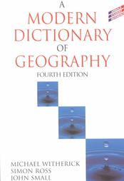
A Modern Dictionary of Geography 4th Edition is a must have for all students of any form of Geography.
The dictionary is by three British professors and it gives academic but straightforward and easily understandable definitions. The book is surprisingly free of political overtones (something which British geography is cursed with). I do think it favors physical geography over the human and technical subfields; however, this does not negate its essentialness to human geographers. On a very plus note it has easy to understand quantitative formulas and explanations of the formulas.
Catholicgauze gives an A+
Category: Books
Thursday, September 14, 2006
The Three-Hundred Fourteenth Post
While I do not believe in numerology I do have experience with "God Winks." Since before I can remember many moments of happiness and comforting events have some how been noticeably associated with "314." It may sound dumb but the sheer number of "314" events have made me wonder if there is something deeper going on in my small sector of the cosmos.
So I hope everyone has a happy 314th post and a merry day!
Postcards to Catholicgauze: Chartres

The second postcard to Catholicgauze is from the Cathedral of Chartres in Chartres, France. The post card is a photo of La rose nord (The North Rose).
The Cathedral has long been a symbol of French royalty. Queen Blanche of Castille donated the money necessary to build the windows in the early 1200s. The French lily and Castle of Castille are seen in several places. Christianity and French churches have a long relationship.
Note the various saints on the bottom. The Madonna in the middle and saint on the far right are Arabs (Orientals). The dress conveys a hybrid between the exotic while still having European undertones.
For more pictures of the Cathedral go here.
Category: Postcards
Wednesday, September 13, 2006
Half of Chinese Do Not Know Chinese
If this is true then the forced Han cultural imperialism has its work cut out for it in multiethnic China.
For more on the new Imperial China read The Geographer’s New Map, Part II: China
Category: Languages
Tuesday, September 12, 2006
NOAA Nautical Maps Now Available
Now NOAA has made a collection of maps available online. The regions of the Atlantic Coast, Pacific Coast, Gulf Coast, Alaskan Coast, and the Great Lakes can be viewed. (Hat Tip: Map Room Blog)
Category: Maps
Monday, September 11, 2006
Wikipedia versus the Red Empire
"The founder of Wikipedia, the online encyclopaedia written by its users, has defied the Chinese government by refusing to bow to censorship of politically sensitive entries. Jimmy Wales, one of the 100 most influential people in the world according to Time magazine, challenged other internet companies, including Google, to justify their claim that they could do more good than harm by co-operating with Beijing." (Hat Tip: Instapundt)
Remembering 9/11

9/11 has changed our way of life and the world in big and small ways. I pondered how to do this post and I still question on how to mark the infamous date.
 I signed up for the 2,996 Tribute Project. I was assigned Hyun-joon (Paul) Lee. He was 32 years old, lived in New York City, and was killed at the World Trade Center. I could find out nothing more about Mr. Lee. However, that does not designify him at all in my mind. Lee was born, grew up, was educated, laughed, loved, cried, had friends, and wondered about his place in the world and cosmos. He is more than number 2341; he is a person whose irreplaceable life was brutally ended by an evil enemy which seeks to this day to destroy Western Civilization.
We came to the monster responsible; we will get more chances. I pray for peace and conversion to peace on all sides but those who live by terror shall die by the same evil forces they use.
Remember who our enemies are. They will lie to decieve us. They will say the West kills Muslim world wide ignoring the massacre of their brothers in Iraq and elsewhere by other Muslims.
September 11th is the date of a great wounding but is also a date of victory in Malta and in Vienna. Let us all rally around the great injustice of 9/11/2001. Let us gain resolve to finish what the enemy started. Remember the horrors of that day. We must be resolved so this never happends again.
For movies I recommend World Trade Center, Flight 93, United 93, Path to 9/11 (edited scenes can be viewed here), and Path to Paradise. For intersites I recommend the above mentioned 2,996 project World Statesmen's Memorial.
Category: War on Terrorism
Sunday, September 10, 2006
Bible Geography Maps
Saturday, September 09, 2006
Representations of Indians and US Army along the Oregon Trail: Rossville, Uniontown, and Saint Marys

After leaving
The first stop was at the
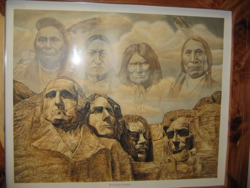
The center itself is merely a few offices and a convention center. Decorations are the tribe’s constitution and general, stereotypical Indian depictions. Included are a painting of an Indian maiden of a stereotypical tribe and the "Founding Fathers" Rushmore painting. Through sheer luck I was able to meet one of the leaders of the tribe. He was a man in his 60s with white skin and a rather heavy mustache. We talked about the tribe’s history in the area. I remarked about the family portraits he had on his wall. They were from the early 1900s and the people had clothing on which would make my blue-blooded ancestors seem like poppers. Fancy dresses and suits abound. I mentioned how they all seemed "white" and he replied that half the people in the picture would "deny with all their effort they were part-Indian. Being Indian was worse than being black back then." I found it a bit ironic that the convention center had generalized Indian decorations and only the office of one of the officials would have tribe related history.
As I left the center I was told the nearby housing project was being built by and for tribal members. It looked like any small town housing project. He also told me a bit of Rossville's history. The last treaty with the Pottawatomi in
Near Rossville was once Uniontown. The thousand plus town was the largest population center in
Next up is Saint Marys. Blogged about before St Marys was the site of a Jesuit missionary and school founded by Farther DeSmet. The mission served the Pottawatomi and offered housing and supplies (for a price of course) to emigrants. The mission site is now in the hands of the Society of Saint Pius X (who is in schism against
Right next by is the Pottawatomi Pay Station and Saint Marys Museum. While the operators are very clearly SSPX members I was able to befriend the ladies and gain a tour of the museum and unlimited access to their library. The pay station was where the government handed out money to tribe members as promised in the various treaties. White traders attempted to secure crooked deals with various Indians but were prevented by Louis Vieux, a Métis and chief of the tribe at the time. The Museum prided itself with local Pottawatomi history and my tour guided repeatedly mentioned how the Jesuits tried to help and save the Indians from complete cultural destruction. Various exhibits showed the history of the tribe and Church.
Saint Marys town emblem is a great contrast to the accuracy of the museum. The local Indians like the Pottawatomi lived in multi-family log houses and the
I left Saint Marys for the long drive into
Category: Oregon Trail
Friday, September 08, 2006
EarthTools: The Geographer's Google Maps
Now if these tools could be (or if someone could show me) integrated into Google Earth or GeoPortal I would be thrilled. (Hat Tip: Spatial Ireland)
Category: GeoInfo, Neogeography
Thursday, September 07, 2006
Waziristan and the War on Terrorism

The Victorious Flag of al Qaeda
Bad news on the war front.
Waziristan is in the western-part of
The truce has an number of points including the Pakistani Army is abandoning its garrisons in North and South Waziristan and will not operate in North Waziristan, nor will it monitor actions the region. The Islamists claim they will kick out all foreign fighters but this seems unlikely since they will not be pressured to kick out their allies.
Most likely the treaty was signed because many generals and other leaders in
Category: War on Terrorism
Wednesday, September 06, 2006
The 100 Angriest Cities in the America
Category: Miscellaneous
Tuesday, September 05, 2006
Nokhchiin: The New Name for Chechnya?
Redrawing the Middle East
------------------------------------------------------------------------------------
Cartography links to an interesting article in Armed Forces Journal proposing a redrawn 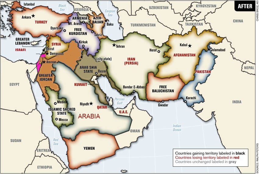
The above map is based on Mr. Peters' work. My changes and thoughts are as follows.
Sunni Iraq and the West Bank (and possibly
Shia
Finally, the crème de la crop,
Category: Maps, Geopolitics
Monday, September 04, 2006
Geographers You Should Know: J.B. Jackson
John Brinckerhoff Jackson was born in
After graduating from Harvard and the start of World War II,
The magazine, and his research, focused on the vernacular landscape (aka everyday landscape). A great example is the home and village/town. From an interview with
Jackson, a professor, never was comfortable with solely academic geographers. He made sure his writings could be understood by the general public and kept it free from post-modern influences. If you have time I recommend one buy or check-out from their local library Landscapes, Discovering the Vernacular Landscape, and A Sense of Place, a Sense of Time.
"I want Americans to explore the landscape for its own sake to develop an intelligent affection for the country as it is and a vision disciplined enough to distinguish what is wrong and should be changed from what is valuable and worthy of protection."
Sunday, September 03, 2006
Hezbollah in the Venezuela
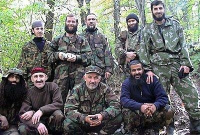
What you are looking at has as much impact as the U2 photos of Soviet missile installations in Cuba
The above is a photo, taken and distributed by Hezbollah, of Hezbollah recruits in
Hezbollah has an MSN Space page and a blog. They seem to like bragging about the merits of Islam and have some beef against the head of Univision calling him a true terrorist.
There are already rumblings of Islamists active in Paraguay which could be a reason why US Special Forces are actively training allies in the tri-border region. If Hezbollah, number 2 when it comes to killing Americans, is working with Chavez to gain a foothold in the West, cable style wars could spread from the Mideast and Africa into
Hat Tip: Gateway Pundit
Category: War on Terrorism
Saturday, September 02, 2006
The Coming Mexican Civil "War"
Let us all pray it ends that way...
The Mexican political landscape is getting much worse. The loser, Obrador, who once vowed to give up even if he lost by one vote is now preparing to set up his own alternative government. He has even threatened violence. Things have reached a new peak with leftist members of Mexican congress blocking the state of the nation speech.
This is very bad for
Finally there is black gold.
If things turn really ugly the center-right has the backing of the military. Democracy south of the border will suffer a huge loss if they come into play.
Category: Geopolitics
Friday, September 01, 2006
Who reads GTWC?
By using my Clustrmap, e-mail subscriptions, Bloglines subscriptions, and Sitemeter I have a geographical break down of the readers of Catholicgauze:
1) Eastern Half of the United States: This is the primary base of my readership. From the Atlantic Ocean to the near the
2) Western Europe: And to be more exact the
3) Western
4) Singapore/Australia Hemisphere Axis: A few readers and their friends are some of the most loyal readers of GTWC!
5) Eastern (scratch that) Central Europe: Readers from
The Geography of James Joyce's Stephen Dedalus
Category: Neogeography, Books