Today is February 29th and that means we are in a leap year. Leap Years help keep calendars accurate. What seems like an obvious need has a very complex history.
The Ancient Romans realized the need for extra time. Their calendars were beginning to get ahead of the actual solar cycle because calendar years are 365 days and solar years on Earth are slightly less than 365.25 days. This means every calendar year six hours are lost and every 4 years a day is lost. So every four years was given an extra day to make up the difference.
Problems still existed. Solar years are 365.2422 calendar days (not 365.25) so a difference was growing. In the late 1500s church officials realized that Easter was coming closer and closer to the Spring Equinox and eventually Easter would start occurring in Winter. So Pope Gregory XIII issued Inter Gravissimas which declared every century not divisible by 400 to be a common year (with no leap day) and jumped the calendar 10 days from October 4, 1582 to October 15, 1582. The change allowed for the new, Gregorian, calendar to be neigh accurate.
The close synchronization will keep the Gregorian calendar aligned with solar time for the next 3,100 years.
Tomorrow: Read how the Gregorian calendar took on the world and how other calendars reflect cultural world views.
Friday, February 29, 2008
Thursday, February 28, 2008
Turkey pushes into Iraq, again
Turkey is sending in more troops to fight Kurdistan Workers Party (PKK) terrorists in northern Iraq. Operation Sun is the latest effort by Turkey to take on the communist rebels.
The Kurdistan Regional Government and the Kurdish Democratic Party (the coalition party which runs northwestern Kurdistan) have protested the incursion but will most likely will do nothing beyond that. Kurdistan's Peshmerga fighters have moved in to keep the PKK from trying to retreat south. Any southern withdrawal would likely entice the Turks to move in deeper. Turkey says there is no timetable for withdrawal but the United States is pressing for one as soon as possible.
The fight has been hampered by the mountainous terrain and bad weather. Turkish commandoes are fighting in waste high snow and freezing cold temperatures. These conditions will likely deny Turkey the "crushing blow" they seek against their long time rival.
Terrorist and other groups in mere presence in Iraq create the risk of other incursions. The Islamic Communist cult People's Mujahedin of Iran (MEK) in the past killed major leaders of Iran and remain a target of Iran's wrath. Mahdi Army Special Groups and Hezbollah are active in Iraq. A big attack by either of them (though they attack Coalition forces daily) could cause Coalition forces to target Iran.
Big News - Upcoming Geographic Travel with Catholicgauze!
This fall the blog will take a temporary new turn. While doing my best to update you all in the world of geography on a close to daily basis there will be a new feature. This fall Catholicgauze will be in Iraq. Look for posts concerning life in Iraq, the geography of Iraq, and the geography of the war.

168,800 Square Miles and Only One Geography Blogger to Cover It
Wednesday, February 27, 2008
Big News Tomorrow
The standard, meatier blog post return tomorrow along with massive news. Catholicgauze is about to take on the world!
World Climate Data
Free Geography Tools links to United Nations Food And Agriculture Organization (FAO), AgroMet division database (150 MB download!) that features climate data from over 30,000 stations. Google Earth viewing files, database viewers, and much more abound here. Check it out today!
Tuesday, February 26, 2008
European Union Surrenders in Kosovo
The Kosovar Serbs are in the process of rejoining Serbia as discussed before. Bridges have been blocked, police have defected, and the Serbs have de facto seceded from the country they never recognized.
The European Union was in Kosovo under a law and order police mission. That was until they withdrew because of violence from the Serbs.
The Balkans troubles were suppose to be the proving ground in which the European Union would justify its existence. Wars were suppose to be a thing of the past as European states gathered together and policed their own. Instead, the region proves yet again Europe's paralysis. The United States is needed to prevent utter choas as was the case in the Bosnia War and the Kosovo War of 1999. While Europe cries across the Atlantic for help do not expect the European supernationalists to stop their cries against American intervention elsewhere.
Sunday, February 24, 2008
Expanding Earth Theory
Before Continental Drift was the accepted theory on the formations of the Earth's surface another theory had some following. Expanding Earth theory's reasoning comes from continents matching up like puzzle pieces (same as Continental Drift). But instead of continents floating around on plates Expanding Earth claims the Earth has been growing since the era of the dinosaurs. Ways of growth are "explained" by phase change of the Earth's materials or gravity fluxes (which allowed dinosaurs to be so big).
Ask most geomorphologists about Expanding Earth and the answer received will be "no." But there are still holdouts like the video above.
Saturday, February 23, 2008
Geographic Genetic Chart

From Washington Post. Click to Enlarge
The Washington Post features an article with the above chart about genetic studies that "map" out humanity's diversity. The chart's information backs up the "Out of Africa" theory of human migration with a center point near present-day Addis Ababa, Ethiopia.
The chart shows the mixture of origins for ethnic groups based on a sample population's DNA. No real surprises but still neat to look at. Russians have some Central Asian pro-Catholicgauzes. Africans are "pure." The information shows the Middle East to be the ancient melting pot with various groups intermixing.
One neat thing to see in future research is to see if the "average" American has more ethnic genetic mixtures than the average Middle Easterner. I assume the United States has more ethnic groups than much of the Middle East but I cannot say how well intermixed America's population is.
Friday, February 22, 2008
Eclipses
On Tuesday much of the United States and parts of the Western Hemisphere got to view a full lunar eclipse. I hope my readers had the oppurtunity to witness such an event.
Encarta has a wonderful interactive explanation of both solar and lunar eclipses. Solar eclipses occur when the moon gets in between the Sun and the Earth. Areas under the umbra, the darkest part of the shadow, have a total eclipse while areas in the preumbra have a partial eclipse. A lunar eclipse occurs when the Earth gets between the Sun and Moon. The red seen on the moon during the lunar eclipse is due to the Sun's light having to pass through the Earth's atmosphere first. Shorter light wavelengths get scrambled and therefore usually red's wavelength dominates.
Astronomers fortunately have well documented eclipses on the internet. Hermit Eclipse has a complete eclipse library from 2000 BC to AD 3000. NASA features tables, Google Maps, atlases, and North American eclipse maps. Finally there is a world atlas of eclipse paths on Google Maps for 1960 to 2100 and the sister site of Google Maps eclipse paths from 2000 BC to AD 3000.
Wednesday, February 20, 2008
Castro Steps Down, Castro Steps Up
Fidel Castro has announced he will be stepping down and laid the groundwork for his brother Raul Castro to officially take over. Nothing is changing.
Raul has been the de facto leader of Cuba since Fidel stepped aside during his 2006 health turn for the worse. Raul has opened up public discussion a little bit on the subject of economic reforms but any reforms will probably be minor such as when he pushed for private agriculture in the mid 1990s.
Raul oversaw the execution of former regime elements after the Cuban Revolution and was involved in frequent purges of the army and intelligence agencies.
The only real change that has a possibility of occurring is Cuba's relation to Venezuela. Raul has calms both personal and political with Chavez. He sees Chavez as a bombastic child who does not realize there needs to be some free market elements for a socialistic economy to survive.
The transfer from Fidel to Raul is the best possible way for a power change for the regime. This way everything is institutionalized and blessed by Fidel. If Fidel were to die while still in power there could have ben a power grab by anti-Raul Communists that could threaten the whole Communist system.
The regime's long time in power has destroyed any chance for an in-country reform movement to implement democracy. The exile community has been out of the country to long to be considered the sole reform body. For freedom to come to Cuba both internal and external parities have to collaborate.
¡Viva Una Cuba Libre!
Tuesday, February 19, 2008
Geography of Forgotten Landscapes: Fort Totten, Washington, D.C.
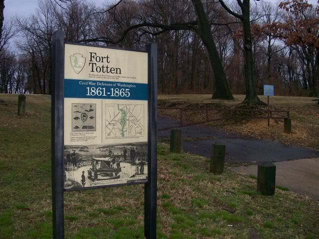
The main sign and Fort Totten hidden in the background
Inside the northeastern end of Washington, D.C. sits a piece of forgotten history. Fort Totten is not abandoned, it is marked by a park which anyone can visit; however it is forgotten by the all.
Fort Totten was created after the First Battle of Bull Run. The United States military realized the capital was poorly defended. So a series of forts (with an interactive map) around Washington were constructed. The forts were made on the rural farmland hills of the district. The forts, including Fort Totten, saw action during the 1864 Confederate raid on Washington.
Today the fort is along Fort Totten Drive right near Fort Totten Metro. Things have changed like the farmland giving way to townhouses. A roadside sign and a plaque which is in risk of being grown over by plants mark the site to no one in particular. Though it is a short walk from the metro no tourists come to visit as they have to pass through an area known as “Rapesville” to some. If locals come to visit it is to drink their beers and not take in history. Students at the nearby Catholic University of America expressed no interest or even knowledge of the fort. The fort and its presences on the landscape is marked yet forgotten.
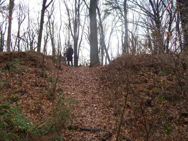
Catholicgauzette Runs the Ramparts

Inside the fort
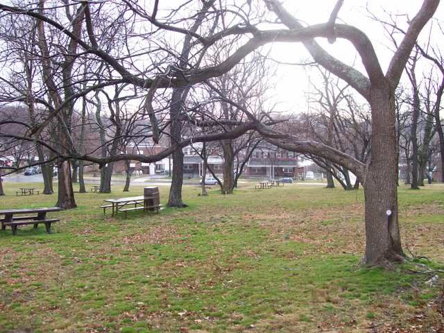
No longer farmland. The fort is forgotten in the northeast of Washington.
Monday, February 18, 2008
Short Bit of Humor: 1776
An actual good piece of social geography if one watches it from a social/cultural angle. While the citizens of the United States and United Kingdom are on friendly terms, this is how many Americans view the heroics of George Washington and the Revolutionary War. (Hat tip: TDAXP and I Hate Linux)
Kosovo: The World's Newest Country

Kosovo's flag has a map in it!
The long awaited vote in the Assembly of Kosovo has taken place and the new Republic of Kosovo was born. The declaration of independence comes after years of quasi-self rule under the United Nations de facto separated from Serbia.
Kosovo is the world's newest Muslim majority country (though it is of a conservative, not puritanical, brand not throughly observed). The citizens now are pretty pro-American supporting both former President William Clinton and current President George Bush for their pro-Kosovar polices.
On Monday some countries are planning to recognize the republic, others will deny it, and others will sit on the fence. The United States, United Kingdom, probably the European Union, Islamic countries, and the Republic of China plan to acknowledge the new country. The countries that do not plan to recognize Kosovo fall into two categories.
The world's newest independent country is unlike other recent one's like East Timor or Montenegro. Kosovo's independence is as important in the geopolitical game as the rise of post-Soviet states. With a new Cold War let us hope Kosovo's geopolitical wake is not as big as Israel's was with independence.
Kosovo is the world's newest Muslim majority country (though it is of a conservative, not puritanical, brand not throughly observed). The citizens now are pretty pro-American supporting both former President William Clinton and current President George Bush for their pro-Kosovar polices.
On Monday some countries are planning to recognize the republic, others will deny it, and others will sit on the fence. The United States, United Kingdom, probably the European Union, Islamic countries, and the Republic of China plan to acknowledge the new country. The countries that do not plan to recognize Kosovo fall into two categories.
- Russia, Slovenia, and other Slavic countries are rallying behind their Serbian cousins.
- Other countries are afraid of de facto independent countries finalizing their split. Romania and Moldova fear Transnistria may be recognized by a vengeful Russia. Georgia has similar concerns about Abkhazia and South Ossetia. Bosnia's legal Serbian Republic's threats of declaring independence is keeping Bosnia and Herzegovina form recognizing Kosovo. The People's Republic of China sees Kosovo as a justification for the Republic of China. Kosovo allows lays the groundwork for Northern Cyprus to be internationally recognized.
The world's newest independent country is unlike other recent one's like East Timor or Montenegro. Kosovo's independence is as important in the geopolitical game as the rise of post-Soviet states. With a new Cold War let us hope Kosovo's geopolitical wake is not as big as Israel's was with independence.
Sunday, February 17, 2008
National Geographic's Map of the Day
One of National Geographic Online's most popular feature is Photo of the Day. People like seeing the standard National Geographic Magazine pretty picture.
We geographers finally get ours. National Geographic has a new feature called Map of the Day. Every Monday through Friday a map is featured with a brief write-up and a trivia question.
(Note: The first map, January 16, shows Northern Cyprus. Weird)
We geographers finally get ours. National Geographic has a new feature called Map of the Day. Every Monday through Friday a map is featured with a brief write-up and a trivia question.
(Note: The first map, January 16, shows Northern Cyprus. Weird)
Saturday, February 16, 2008
Historical Atlas of Canada
The Map Room links to the Historical Atlas of Canada online. The atlas combines image maps with interactive ones in a sort of GIS interface. While slow, it is neat that one can toggle different layers and see change over time. The ability to customize the information displayed spatially further advances educational value and appeal.
Friday, February 15, 2008
Map of Human's Impact on the Oceans
 From Science Daily
 A new map by a group of scientistsat the National Center for Ecological Analysis and Synthesis have created a map that shows man's impact on the oceans.
The map shows only four percent of the world's are left mostly untouched by humans. These are found hugging the coast of Antartica, very remote northern Russia, and very remote regions of the northern islands claimed by Canada.
The places impacted the most and worst are the North Sea region (lots of British and Norwegian oil drilling), the East China Sea (China's economic output is literally pouring into the sea), and the Singapore straits (one of the most heavily trafficked bodies of water).
Man's impact on the oceans is vast ranging from horrible dead zones to positive things like artificial reefs. So like terra firma, the ocean's are now as much a cultural landscape as they are a natural landscape.
Thursday, February 14, 2008
Imad Mughniyeh Killed, Beirut Rallies, and the Upcoming Future

Hezbollah terrorist and leader of its military faction Imad Mughniyeh was the victim of a car bomb on Wednesday. Nobody knows who did it yet but Hezbollah, Iran, and Syria are all blaming Israel. Israel is a high possibility because of the skill the assassin(s) needed to have to infiltrate the police state Syria.
Mughniyeh was the deadliest terrorist against the United States until bin Laden’s al Qaeda topped Hezbollah on the most American’s killed list.
Today, Feburary 14th, was an active day in Lebanon. The March 14th Alliance held a rally in remembrance of assassinated former Prime Minister Rafik Hariri. The assassination has given Hezbollah the chance to counter the rally with a massive funeral for Mughniyeh on the same day. The rallies are five miles apart but bad weather and efforts by both sides will prevent massive violence… for now.
Hezbollah has declared war on Israel. However, the group has been in a state of aggression since its creation so time will tell if the expected reprisal attacks are just that or the opening of a new front.
Meanwhile, the world continues to ignore the captive state of Lebanese democracy.
Wednesday, February 13, 2008
The Overlooked: Ahwazi Arabs
 From the British Ahwazi Friendship Society
 Three million Arabs live under the control of a foreign power which share little of their culture and values. Their country lies in ruins, religious institutions are co-opted, services denied, and political activities outlawed. However, unlike the Palestinians there is little to no international concern about these Arabs. These Arabs are the Ahwazi Arabs of present-day Khuzestan, Iran.
Location
There are approximately three million Ahwazi Arabs living in Khuzestan.
Culture and Religion
Most Ahwazi Arabs are Shia Muslim like the vast majority of Iranians. The religious minorities of Ahwazi Arabs are mostly Sunni Muslim but there are Mandeans, Gnostics who believe John the Baptist is God's highest prophet (and believe Jesus corrupted John's message). The tribal system still exists and continues on into major cities like Ahvaz. Some tribes have kin in the southern part of Iraq.
History
From the 1500s until the early twentieth-century the land of Khuzestan was known as Arabistan. The name was earned by various Arab tribes who invaded the region. Arabistan was an autonomous province which paid taxes to Persia and little else. The late nineteenth century saw the rise of British influence. The Brits and Arabs worked out trade agreements and looked out for each others interest. All this understandably caused the Persian regime to get upset. Things changed though in 1925. Reza Shah founded Iran from Persia. Shah had the backing of the British because of his strong anti-Russian policies. Shah deposed the leader of Arabistan without British influence and made renamed it Khuzestan.
Khuzestan's marginal economy was boosted with the rise of the petroleum industry (90% of Iran's oil is found in the province); however, most of the funds stayed in the hands of Persians who moved into the region to run the oil business. Arabs complained that the pro-Persian government ignored the needs of Arabs.
Everything changed in 1980. Saddam Hussein's Iraq invaded Iran. Hussein hoped the Ahwazi Arabs would rebel against the new Islamic Republic in favor of Arab Iraq. Ahwazi Arabs instead picked up arms for Iran and fought the much more technologically capable Iraqi Army to a bloody halt. Hundreds of thousands of Ahwazi Arabs lost their homes and fled to relatively safe places like Ahvaz.
The sacrifices of Ahwazi Arabs were not rewarded by the Persian Islamic Republic. Redeveloped areas were given to Persians and Azeris who moved in from elsewhere. All but the lowest paying jobs were denied to Ahwazi Arabs, Arab language newspapers and media broadcasts were outlawed, and political activities curtailed. In 2003, an Arab party won local elections in Ahvaz but it was then outlawed for being "ultra-reformist."
Today
Today Ahwazi Arabs are a people under occupation and cultural siege. The Iranian government does not allow education in Arabic. Public executions are a monthly affair. Khuzestan is one of the richest provinces yet the wealth is only found with the Persians and Azeris who move in for the oil jobs.
Though the Ahwazi Arabs are not playing innocent victims - a series of bombings, riots, and assassinations have been preformed. The Sunni minority allegedly has ties to al Qaeda while Iran claims the secular groups are also involved in terrorism.
Additional Resources
The National Liberation Movement of Ahwaz - Political News Site
British Ahwazi Friendship Society - Political News and Cultural Information (Note: on February 12, 2008 the site was currently hacked by Iranian hackers)
Warning: Graphic Scenes in Film
Tuesday, February 12, 2008
Drums of War Begin to Beat in Lebanon
Lebanon continues its slow, worrisome march towards war. Currently the pro-West Christian and Sunni March 14th Coalition in parliament has a slim majority the ability to appoint the next president of Lebanon. However, the pro-Syria/Iran axis of Shia Hezbollah, Shia Amal, and Christian Free Patriotic Movement’s March 8 Alliance stands in the way.
Assassinations, riots, threats of violence, and rallies which Hezbollah’s leader Nasrallah talks of enemies’ heads he has collected have cowed March 14 into not declaring a president just yet. March 14th has proposed a compromise, General Michel Sulaiman, but March 8 feels it can gain more concessions so it is playing hardball.
The situation is becoming unbearable for some of March 14. Druze leader Walid Jumblat, who is famous for wagging war against everyone during the civil war and winning, has threatened war against March 8th if they continue aggression. Various translations vary on what exactly was said but Hezbollah released a public statement calling Jumblat said “You want war, we welcome war. You want chaos, we welcome chaos.”
The situation is getting dire in Lebanon. Al Qaeda is also running around randomly attacking UN troops and may possibly be involved in assassinations as well. While the world is focused on Iraq and Afghanistan, democracy in Lebanon is struggling to survive.
Sunday, February 10, 2008
East Timor's Closes a Chapter
Rebel Major Alfredo Reinhado is dead. His death closes a chapter in East Timor's bloody history.
Reinhado was a member of East Timor's army until he was ordered to assault strikers in 2006. Reinhado then disobeyed orders and ordered his men to protect the strikers. Then until his death Reinhado was laying low only to venture out to harass East Timorese and Australian army forces.
That is the story Reinhado like to tell anyways. While true it ignores the geographical discrimination which is tearing the troubled country apart. Reinhado and the strikers were from the western part of the country while many who run the government were from the east. Easterns pride themselves as freedom fighters who fought against the Indonesians while they accuse westerners as former collaborators. Reinhado attracted most of is support from westerners who had ligimate beef against the elite's sterotypes.
However, Reinhado "got greedy" and attempted to seize the president and launch a coup. He was killed by the military and his body has been identified. With his death perhaps easterners and westerners will have the chance to start again.
Map My Run: Ultimate Geographical Tool for Outdoor Exercise
Map My Run is a neat tool for all those who enjoy outdoor exercise. The interface combines the familiar Google Maps board with tools for making paths, displaying geographical data like distance and elevation, and physical statistics.
One can choose from activities like walking, hiking, running, biking, swimming, and skating. Try it out today and see just how much calories you can burn!
One can choose from activities like walking, hiking, running, biking, swimming, and skating. Try it out today and see just how much calories you can burn!
Saturday, February 09, 2008
Sun Cycles to Cause Global Cooling?
Solar activity is on an eleven year cycle of ups and downs of solar output. Today some scientists are noting that while they are not noticing an doomsday levels yet, the sun is "disturbingly quiet." Output is at a low level and not ticking up as it should according to the cycle. Some fear that this could lead to a Maunder Minimum.
The last Maunder Minimum coincided with the worst part of the Little Ice Age. If so then the Earth is on track for years of global cooling. When studying environmental geography it is important to remember the Earth is not an "island."
The last Maunder Minimum coincided with the worst part of the Little Ice Age. If so then the Earth is on track for years of global cooling. When studying environmental geography it is important to remember the Earth is not an "island."
Friday, February 08, 2008
Georgia Wants to Occupy Tennessee
Georgians must read Catholicgauze because a proposal in the state’s legislature calls for the annexation of the lost land given to Tennessee by geographical error.
I am not sure how this could be done without a) the unlikely event of federal government intervention and a treaty between the two states or b) the even more unlikely event of Georgia sending its national guard to occupy the sliver of Tennessee.
(Note: Hmm, the author of the American Surveyor article which is the origin for the original post is from Georgia, perhaps it we are seeing the beginning of a cabal to occupy Tennessee! Tennessee bloggers like Instapundit should be up in arms)
Thursday, February 07, 2008
England versus Great Britain versus United Kingdom

In everyday American English Great Britain and United Kingdom are used interchangeably. England too can be used to signify the whole country. There are however key differences between the three.
England, Scotland, and Wales are three constituent countries united under one state, the United Kingdom, on the island of Great Britain. The United Kingdom is the three countries of Great Britain plus the country of Northern Ireland.
The British Isles are Great Britain, the island of Ireland, and a bunch of other small ones like the Isle of Man. The Isle of Man's Lord is the monarch of the United Kingdom but the island is not part of the United Kingdom nor is it a part of the European Union. The same holds true for the Channel Islands of Guernsey and Jersey (but these islands are not part of the British Isles).
Finally there is the Commonwealth of Nations which is a voluntary association of former British (ugh, I do not know the correct word to use) colonies plus Mozambique (which wanted to be politically closer to its neighbors). Each member has the UK Monarch (sans Mozambique) as their own king or queen but remains politically independent.
And you thought the Dutch were confusing.
Wednesday, February 06, 2008
European Cities Game
The self-styled Catholicgauzette recommends a challenging European cities game. The goal of Virtual Pilot is to land the transatlantic jet in the correct European city. After the first round it gets difficult! Best of luck! Try to beat my first score of 28,059!
Tuesday, February 05, 2008
Serbian Kosovars Role in a New Kosovo

Moderately pro-Europe Boris Tadić defeated a much more pro-Russian candidate for reelection to the presidency of Serbia. Kosovo will declare independence while Tadic’s Serbia gives nominal protests but swallows its pride in order to eventually gain entry into the European Union.
While Serbia will take Kosovo’s independence lying down do not expect the Serbs in Kosovo to be passive. Serbs have made public declarations that they will form their own local government which will report to Belgrade and not Pristina. They may even push for reentry to Serbia using the same ethnic homeland logic which will grant Kosovo’s independence.
North Kosovo, the area north of the Ibar River, makes the easy place for Serbs to reunite with Serbia. Ethnic enclaves are islands of Serbs in a sea of Albanians. Most these are in the eastern section of Kosovo but will likely either remain holdouts or abandoned. Eventually Kosovo Albans will take these over. A majority Serb district in the south will provide temporary refuge for isolationist Serbs. The region will be an arguing point between Serbia and Kosovo over who has control of it. Look for Strpce to become a less violent but still intense Nagorno-Karabakh.
Identity will play the biggest role in if there is ethnic upheaval in an independent Kosovo. Kosovo’s leaders will have to forge a Kosovar identity which includes Serbs if they wish to keep the country whole. Limiting overt Albanian pride (like having a flag which is not 100% the same as Albania’s) and keeping Serbs protected from foreign Islamist radicals will be key.
Monday, February 04, 2008
Geographical Error Leads to Georgia's Water Shortage
A big debate in the American South right now is Georgia water's shortage. Lack of rain combined with very bad practices (Atlanta's golf courses use untold amounts of water just to keep the fairways green everyday) have led to water shortages throughout the state. Debates on Capitol Hill have routinely boiled down to Georgia complaining that Tennessee, South Carolina, or Alabama will not share extra water.
Better geographical skills back in 1818 may have solved this current problem. The surveyor for the government, James Camak, used obsolete tools to map the Georgia, Alabama, Tennessee border. Errors done by Camak placed the border for Georgia over a mile south of where it should have been. The border change denied Georgia access to the Tennessee River. The river's water could today alleviate much of Georgia's shortage. (For more read: Geography Matters, The American Surveyor Magazine, and Professional Surveyor Magazine)
Water and human's access to it are big issues today in geography. Domestically the Colorado River is a concern. Mountain states are battling California and Nevada over how much is taken. Dams and plans have been designed to try to balance different demands. California needs the water for growth as does Las Vegas, a city never meant to exist geographically. Such engineering has been done that the once muddy, warm waters never the Grand Canyon are now clear and cold. Internationally debates over the Sea of Galilee and the Jordan River have Syria, Lebanon, Jordan, Israel, and the Palestinian Authority at each other's necks constantly.
Sunday, February 03, 2008
Literary and Cultural Heritage Map of Pennsylvania
The Literary and Cultural Heritage Map of Pennsylvania is a neat educational map which highlights the literary history of the state. Each county has a blurb which can be viewed if one moves the mouse cursor over it. Clicking on a county will bring up a closer view with more features which can also be viewed via the cursor. Interesting liteary triva abounds. For instance, Scraton is known for much more than just being the location for the American television version of The Office.
Saturday, February 02, 2008
Cartographic History of Empires
Coming Anarchy has a neat set of posts showing the rise (and in some cases) fall of empires. Currently they have created sets of maps for the Persia, Poland, Ethopia, Russia, and Aremnia. The maps are accompnaied by caption which briefly describe the geographical scene.
Coming Anarchy also has a map post showing the rise and fall of the Roman Empire from 510 BC to AD 1453.
Coming Anarchy also has a map post showing the rise and fall of the Roman Empire from 510 BC to AD 1453.
Friday, February 01, 2008
Internet Outages Between Egypt and India
Two major undersea cables have been cut off the coast of Egypt. The cuts have severly limited bandwidth between Egypt and India. So everyone from US Central Command, Iranian bloggers, Hezbollah terrorists, to Gulf State merchants are feeling the pain. Dubai et al are major player s these days in the world economy so the loss of easy communication, the life blood of globalization, will surely be felt around the world. Foriegn Policy Blog has more.
Subscribe to:
Posts (Atom)