Reader and soon to be Doctor Deaner has sent Catholicgauze an online GIS website showing coal impoundment locations in America.
Impoundments are sort of dams which hold coal slurry waste. These sites are necessary environmental hazards. Besides the standard risks of having slurry lakes, the dams have broken in the past creating killer waves which destroy everything in its path. Catholicgauze is glad the site says there are no impoundments nearby and that he lives in an area so flat that a major river flows backwards when it floods.
Saturday, June 30, 2007

Friday, June 29, 2007
International Piracy Map
The International Maritime Bureau features the interactive Live Piracy Map which plot modern piracy activities by year. (Hat tip: Coming Anarchy)
It is clear that the area slightly north of the equator is the place where piracy occurs. Certain hot zones exist.
For more on modern piracy read the short Popular Mechanics article.
It is clear that the area slightly north of the equator is the place where piracy occurs. Certain hot zones exist.
- Off the coast of the Guianas seems to be more or less thugs.
- The coast from Liberia to Cameroon is another problem area. Here are spill overs from civil wars, ethnic conflicts, and general criminal activity from Nigerian tribes (the one's who take oil workers hostage).
- The Horn of Africa has long been a problem. From attacking cruise ships to conflicts with the United States navy, here the pirates are problem the most well armed. RPGs are not an uncommon sight. Warlords, criminal gangs, and Islamists groups like the former Islamic Court Union have all engaged in piracy.
- Bay of Bengal has been more and more a trouble spot. The Tamil Tigers navy has even begun to worry India.
- Southeast Asia has long been a pirate hot spot and continues to be so. Economic troubles in Indonesia and elsewhere has made piracy an appealing choice to some.
For more on modern piracy read the short Popular Mechanics article.
Thursday, June 28, 2007
Fireflies
This short post is dedicated to MMM, you finally get the post
If one looks out of their house at night during the summer they may be blessed with a sight to behold. Little flickers of light may dash across the surface. These lights are not UFOs but fireflies.
The geography of fireflies is one that just goes to show insects rule the world. The range of fireflies extends as far north as Greenland down to almost everywhere south excluding the tip of South America and all of Antarctica.
Out of 2,000 species of fireflies, 1,200 are in the Western Hemisphere and 123 are found in the United States. The height of the American firefly season is late June to late July but various species are active as early as April or late as October.
Americans use the term firefly and lightning bug. Lightning bug is the prefered term down in the Southern states while firefly is used elsewhere.
The Geography of International Baseball

The Cores and Peripheries of World Baseball
Professional baseball has expanded into Israel. The Israel Baseball League hosted its first game as the Modi'in Miracle crushed the Petach Tikva Pioneers nine to one. Israel joins the international baseball community with this modern reintroduction of the sport. Baseball was frequently played in Old Testament Israel but lost favor with Saint Paul's career in NASCAR.
Israel now joins the international world of baseball. Baseball's distribution can be broken down into three core and three periphery zones.
The historic home of baseball is the American Core. Baseball evolved from the British game of rounders. Throughout the 1700 and 1800s the game was played with a variety of rules until "Knickerbocker Rules" became the basis of the modern game. Today the American core is comprised of the United States and southern Canada. Baseball once was the major national sport in America but has lost out to football.
The Hispano Core has historic ties with the American Core. Cubans played baseball as early as the 1860s. The game was played by American sailors and Cubans who were schooled in the United States. Baseball was even viewed as a threat by Spanish authorities who viewed it as a protest against Spanish cultural traditions like bull fights. Emigration from Cuba during its revolution brought the game to the Dominican Republic. Cultural interaction with the United States brought the sport to Panama, Mexico, Venezuela, and Puerto Rico. Many Major Leagues play in the Hispano Core's winter leagues. Recruiting by the Major Leagues is heavy in the Hispano Core.
The Far East Core has a history as long as the Hispano Core. Professor Horace Wilson brought Baseball to Japan in the 1870s. The game slowly gained popularity. Before World War II, Major League Baseball players traveled to Japan in order to play in exhibition games and operate sports clinics. Baseball was viewed negatively in Korea because of its Japanese popularity. The permanent stationing of American military reintroduced the game. Today Japan and South Korea are bitter rivals whose players are being scouted by the Major Leagues. The Far East Core proved its worth with Japan's victory over Cuba in the 2006 World Baseball Classic.
The Far East Periphery is an area where baseball is growing in popularity. Taiwan received baseball from Japan but the game was long viewed as a child's activity. Taiwan is a major player in the Little League World Series. Professional baseball started in the 1980s but has been greatly damaged by game fixing scandals. The People's Republic of China has recently picked up baseball. This is partially due to China's effort to dominate sports.
The European Periphery got its start from American military after World War II. Many of the first teams were actually formed by Americans who recruited locals to fill in spots. Russian soldiers have recently begun their own minor leagues with slight expansion into the general public. Italy and the Netherlands are so far the only countries of note. However, there are efforts to improve European baseball in time for the next World Baseball Classic. Wales is an active center of "British Baseball" which can be thought of as 75% baseball 25% cricket.
The Down Under Periphery comprises both Australia and New Zealand. Baseball is weak here but there are efforts to reestablish a league. Cricket is viewed as the proper sport and has so far been successful in keeping baseball minor. However, the success of the Australian women's softball team in the Olympics has increased interest with women. Australia now has a woman's baseball team which has earned respect in international competitions.
Wednesday, June 27, 2007
British pub to become embassy of Redonda
A British pub has come up with a way to bypass a July 1 smoking ban: become foreign soil. The plan is to have the pub become an embassy of the Kingdom of Redonda.
There is a problem, though. Redonda is an uninhabited island officially part of Antigua and Barbuda. The "kingdom" is actually a line of literary authors who claim succession from Matthew Dowdy Shiell, a banker who claimed he was given the title of king by Queen Victoria. To make the claim even less solid is that there are a total of nine people claiming they are king.
The odds of the pub being recognized as a foreign embassy are slim to nill. However, one can never be sure because bureaucracies like the British Foreign Office are known for the rare colossus error (not going to happen, but would be cool).
Tuesday, June 26, 2007
Orbitron: Tracking Satellites Online
Orbitron is a small yet powerful program that allows one to view locations of satellites and even the International Space Station. The program is aiding Catholicgauze in finally finding out which satellite buzzes over home base at night. Combine this with Stellarium and one has a pretty handy astronomy suite. (Hat tip: La Cartoteca)
While Orbitron is fun, mad scientists be warned. The rumor that "Orbitron + Google Earth = Shooting Down Satellites" is false.
While Orbitron is fun, mad scientists be warned. The rumor that "Orbitron + Google Earth = Shooting Down Satellites" is false.
Monday, June 25, 2007
Atlas of Floods Worldwide

Dartmouth College offers the World Atlas of Flooded Lands which maps floods from the 1990s to 2006. An interactive map menu allows one to zoom to regions of the world.
Another interactive map of the world allows one to view major flood events by year starting 1985. Additional information on the floods is available in tabular data. Do not forget to view the animated GIF maps the world, Southeast Asia and Australia, and Europe.
Sunday, June 24, 2007
Bringing Back Geography

Geography@about.com links to the must read essay of the year entitled Bring Back Geography! The essay is long but well worth one's time. I will not summarize the essay but touch on key points and offer thoughts.
Three Main Points Catholicgauze and the Essay Agree
Geography Gets No Respect
When I was earning my degrees I was constantly asked what I was studying in school. I replied, of course, "geography." Almost every time the reply back was "What are you going to do? Teach?" Too many people think geography is just remembering countries and the three main exports. It is because of this that university close down geography departments. With little upper level education, teachers and other college students get no proper geographical education. No good teachers means geographical illiteracy becomes common in a society.
Geographers Are Partly to Blame for the No Respect
I told a friend something important when we were helping out the state Geography Bee. I said something along the lines of "You know how we always claim geography is more than place trivia? What are we doing here?" When studies by National Geographic and others exemplify how kids do not know geography, we make it appear geography is place trivia and for kids. I hate to brag about we need more Catholicgauzes in the world (a horrible thought!). There are dozens of excellent blogs out about geotechnology but how many geography blogs are there? Geographers need to be interacting with people showing what geography is.
Geographic Illiteracy Ranges from Embarrassing to Insulting to Dangerous
The risks involved with being geographic illiteracy are numerous. You can embarrass yourself like CNN did by labeling Syria as Afghanistan, you can insult the inhabitants of the country you are visiting by making the symbol of group that murdered 70,000 of your country men chic like Cameron Diaz did, or you can greatly minimize your effectiveness as an army like General David Petraeus realizes in observation nine [PDF]. Geographers must teach the public how things operate in a globalized world. We need to tell people how an economic downturn in China will change their shopping habits or if tribes in Nigeria become angry then oil price will shoot up. We must also go beyond human geography. Geographers can take the lead in discussions on the environment but so far we remain silent.
Three Extra Fights
Fight for Our Right
Today a popular thing for universities to do is multidisciplinary programs. Geographers work well with other disciplines. However we must protect our turf at all cost. We excel by nature at area studies, environmental sciences, and GIS. Any attempt to spin these off to another department or as an independent branch must be opposed. Also, any attempt to merge geography with another department makes it a grab bag of left overs.
Fight "The Infection"
You know Catholicgauze very well if you know the first time this came up. An anti-establishment disease crossed over from European departments to American ones. Too many geographers refuse to participate with military operations (there was a debate in several geographical journals over this issue after 9/11), in mainstream studies of globalization (the best work on the subject, Commanding Heights, noticeably lacks a geographer's input), or any other study "the corporate machines of the world want us to do." That is a real quote. Geographers waste their gifts and will be replaced by others if they insists in locking themselves in their ivy-tower prisons.
Fight for Proper Use of Tools
When I was teaching Environmental Geography lab I allowed students to use my laptop's version of Google Earth. The students looked up their houses and then stopped. They saw no further use. Then I showed them various layers such as weather and earthquakes around the world. I used the displayed data to convey spatial themes behind climate zones and the Ring of Fire. The students then realized Google Earth was not a mere earth viewer but a tool to help explaining geography.
Too often geographers let tools take a life of their own. I have warned against this. When a president of a major geographical association went to Harvard to celebrate its new GIS lab, he erred. The GIS tool was taken by others at the school and geography lost its right and place at Harvard.
Parting Thought
I could repeat the phrase "geography matters" but that would be preaching to the choir. Geographers need to reach out to the public, to school teachers, to leaders what geography is and how geographical knowledge can aid in many situations.
Saturday, June 23, 2007
120 Years of Banff National Park
Today is the 120th Anniversary of the Rocky Mountains Park Act. The act passed by the Canadian Parliament created the first national park in Canada. The act was modelled after the 1881 American act which formulated the idea of a national park with the establishment of Yellowstone National Park.
Rocky Mountains National Park was later renamed to Banff National Park.
Rocky Mountains National Park was later renamed to Banff National Park.
Mohammad Sarwar politically martyred by the microstate
Pakistani-born Mohammad Sarwar is the first Muslim ever to serve in the British Parliament. Sarwar also has become the first national British politician to be a victim of the Islamist microstate.
The wraith of Islamists fell on Sarwar because he used his Pakistani contacts to capture Islamist gang members Imran Shahid, Zeeshan Shahid, and Mohammed Faisal Mushtaq. These three thugs terrorized the Pollokshields neighborhood of Glasgow, Scotland. They were wanted because of the kidnapping, torture, and murder of fifteen year-old Kriss Donald. Donald was murdered because he was not a Muslim. After the attack on Donald, the terrorists fled to Pakistan.
Because of Sarwar's involvement in apprehending the terrorists, a torrid of threats have been made against his family. So many in fact that Sarwar will not seek reelection. Today is a sad day for Europe and freedom. (Hat tip: LGF)
Friday, June 22, 2007
Lightning Phenomena Solved
Sprites come up as quick flashes
There have been moments in my life where I have seen weird things including ball lightning. I have also heard a story from two very reliable sources about a strange phenomenon during a stormy night which can be described as "hostile."
Recreated ball lightning
For years these strange occurrences have been ignored or mocked by scientists. Now two developments might be able provide some explanations. Scientists have recorded bright "sprites" which are very briefly brighter than Venus. Earlier this Brazilian physicist managed to create a form of ball lighting. The orbs bounce on the ground as well as spin and vibrate.
Now sprites and ball lightning may be able to join St. Elmo's fire as explained electrical phenomena.
Two examples of St. Elmo's Fire
Thursday, June 21, 2007
Sulfur Island renamed Sulfur Island
Iwo Jima has official been renamed Iwo To. While both names translate to "Sulfur Island" in English, the change renames the island to what locals had called it before.
The Guardian states the island was "always known" as Iwo To before 1944. The article goes on to say "It only became known as Iwo Jima because Japanese officers who arrived to fortify the island after its residents were evacuated got the name wrong." Research has shown this not true. The Eleventh Edition Encyclopedia Britannica (1910-1911) calls the island "Iwo Jima" in the "Volcano Islands" entry. The 1943 National Geographic Map of the World also identifies the island. As do earlier National Geographic maps.
So the Guardian is wrong. Catholicgauze cannot be for certain but it appears that "To" might be a regional name while "Jima" could be a mainstream/Tokyo word. What we have here seems to be a battle between locals and a dominating national culture. It is surprising to see local culture win in such a conforming country as Japan.
Final note: Do not expect to see information on the Battle of Iwo To; however. Conflicts in places that have changed names such as Leningrad/Saint Petersburg and Stalingrad/Volgograd use the historical name. So rest assured you can still rent movies with names like Letters from Iwo Jima.
Wednesday, June 20, 2007
Failed States Index

Failed states of the world. Click to enlarge
Sudan, Iraq, Somalia, Zimbabwe, and Chad are the five most failed states in the world according to Foreign Policy's Failed State Index.
Variables include demographic pressures, refugees, group grievances, economy, human rights, and security. Liberia, Indonesia DR Congo, and Bosnia have made the most improvement since last year. Countries going down the tube are Niger, Equatorial Guinea, and Somalia. However, the Lebanon was the biggest collapse.
Failed states during Cold War were located in the "global south." Now as Central America is torn between globalization and failed Marxist policies after a decade of progress, most failed states form a cluster between middle Africa and Central Asia. TDAXP calls this the Afro-Islamic Gap. African and Arab kleptocracies are more concerned with personal gain while Islamists favor ummah (Islamist's version of globalization) versus neo-liberal globalization.
Now for a bit of cartographic criticism. Montenegro is shown as part of Serbia. It is time to update, Foreign Policy. Also, the decision to color shallow water differently from the ocean was a mistake. It has no purpose on a political map and it makes it difficult to tell what the status of Greece and other small countries are. (See, Catholicgauze did pay attention in cartography class way back)
Tuesday, June 19, 2007
ReDistricting: The Gerrymandering Game
Political parities realized the benefits of gerrymandering early on in American republican history. The ability to form districts to produce favorable results is commonly used by both political parties.
Now it is your turn. ReDistricting The Game by the USC Annenberg Center allows one to try several scenarios to try your luck gerrymandering. Be sure to produce results beneficial to your party while being able to withstand objections from the other side, legislature, governor, and most importantly the courts. The game also allows one to try out an alternative to the blatantly political gerrymandering system and read up more on the subject. (Hat tip: The Map Room)
Now it is your turn. ReDistricting The Game by the USC Annenberg Center allows one to try several scenarios to try your luck gerrymandering. Be sure to produce results beneficial to your party while being able to withstand objections from the other side, legislature, governor, and most importantly the courts. The game also allows one to try out an alternative to the blatantly political gerrymandering system and read up more on the subject. (Hat tip: The Map Room)
The End of Children Roaming
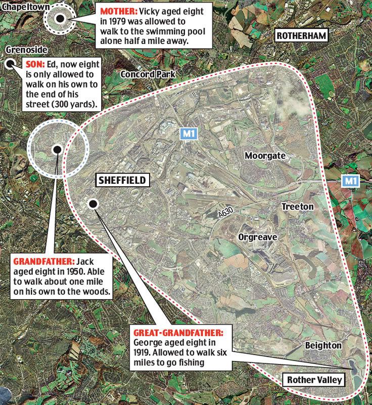
The end of roaming and an appreciation of local geography
Written from a Generation Y perspective: How many times did we hear from our grandparents, "I walked five miles to school up hill both ways." The story usually is not heard from our parents, however. The increase in scale of living allowed our parents to be driven to locations or at very least bike. Catholicgauze's generation was blessed with the same benefits but the increase in perceived crime combined with Satanic Panic, kidnapping fears, and other hysterias to limit our roaming. Today's youths are limited even more in their freedom.
The Daily Mail has an excellent article describing the end of roaming children phenomenon. The article brings up why we should care about the lack of roaming. First off is the simple matter of physical health and exercise. Geography also comes into play, though. A roving child comes into contact with a variety of natural and human landscapes. This allows for an acquired apprication of the world (or at very least different enviornments). Even in a city, different neighborhoods can educate one immensely about people and the world. Geography, even local geography, matters.
Monday, June 18, 2007
Hamastan and Fathia

The two state non-solution. Palestinian controlled territory in Green
As warned, the quasi-not-quite state of Palestine is no more. Hamas has managed to defeat Fatah and conquer the Gaza Strip. Hamas is celebrating by looting, murder, imposing Sharia (Islamic Law), and outlawing gunmen with masks unless they shoot at Israelis. Fatah has responded by storming the few Hamas outposts in the West Bank in an attempt to prevent footholds. The average Palestinian in Gaza is trying to come out of the situation in one piece. Some are even fleeing to Israel where it is possible to apply for citizenship. This is in stark contrast to the neighboring Arab countries, excluding Jordan, which do not grant citizenship to Palestinian refugees.
The conflict between Hamas and Fatah has brought down the government. The Palestinian Authority President Mahmoud Abbas has fired Prime Minister Ismail Haniyeh and dismissed the government. Haniyeh is ignoring this and has become the de facto leader of the Gaza Strip (Hamastan). The government over in the West Bank is now full of Fatah, independents, and other minor parties (Fatahia).
The majority of countries are backing the Fatah-led government in the West Bank. The United States is even offering aid to Fatah in an effort to destroy or diminish Hamas. Iran and Syria are the two major exceptions. Jordan has gone as far to blame unnamed “regional forces” (Iran and Syria who fund Hamas) for the violence. With a Palestinian population above fifty percent, Jordan has cause to be alarmed.
Israel is weighing its options but it may be forced to act earlier than it wants. A Hamas-allied group launched rockets from Lebanon into northern Israel. Catholicgauze doubts the ability of the United Nation forces in Lebanon to prevent any more attacks. However, the new defense minister of Israel is former Prime Minister Ehud Barak. He withdrew Israeli forces from southern Lebanon. I doubt he would be he would be in favor of any major on the ground action which could result in Israeli holding any Lebanese territory.
As for Hamastan there are three possible choices with several combinations. Israel could invade itself, allow Fatah to invade, or have Egypt crush Hamastan in exchange for handing over the ghetto which is the Gaza Strip. The ball is once again in Olmert's court.
Sunday, June 17, 2007
Who Owns the Moon?
The Moon (Luna) can be considered the eighth continent. Scientist believe the Moon was once part of the Earth until Theia (a Mars-sized celestial object) slammed into the Earth around four and a half billion years ago. Ever since it has been a missing family member, ignored by earth scientists while astronomers treated it like any other rock in space. It is time for that to change.
The dawn of space travel and now space tourism has led to legal questions concerning the Moon and given law geographers something else to talk about. The space faring countries of the United States, Russia, China, and others who have not sent people into the heavens have signed the Outer Space Treaty which treats the Moon like international waters. No one can claim it but everyone can use it. Another treaty known as the Moon Treaty sought to limit resource extraction but the treaty has not been signed by any major space power.
So right now the Moon is open to all sorts of activities. People like Dennis Hope make a living off scamming people claiming to own the Moon. Hope claims the Outer Space Treaty only prevents countries from owning the Moon and not people. This is only a half truth and the international waters analogy has to be used again to make things clear. Any private person or group can access resources in international waters. However, no one can own the resource while not directly utilizing them. So it is open season. If Hope is not on "his property" with a shotgun there is nothing stopping Catholicgauze offering Bishop of the Moon property titles to anyone who wants it. So unless you are willing to homestead, avoid buying moon property. The same goes for those who claim to own property on other planets or name stars for a fee.
The Moon and space are free (you just have to pay millions to get there).
Saturday, June 16, 2007
Best Places to Drive in America
Allstate has released Allstate America's Best Drivers Report (PDF of list)which lists cities by the longest period of time between car accidents for the average driver.
The top five are
For a good place to live, try the interior of the country. Sioux Falls has already been noted by having good disaster response. So when you do get into a bad accident the emergency services will have no problems communicating your need for help to the ambulance.
The top five are
- Sioux Falls, South Dakota (13.7 years between accidents)
- Fort Collins, Colorado
- Flint, Michigan
- Warren, Michigan
- Hunstville, Alabama
- Jersey City, New Jersey
- Glendale, California
- Elizabeth, New Jersey
- Washington, District of Columbia
- Newark, New Jersey (5.2 years between accidents)
For a good place to live, try the interior of the country. Sioux Falls has already been noted by having good disaster response. So when you do get into a bad accident the emergency services will have no problems communicating your need for help to the ambulance.
Friday, June 15, 2007
Infonaut's Blog
Infonaut is a private company which provides geospatial information and analysis to medical groups. On the free end of their website are two things. The first is a blog which covers general geography and medical geography. Catholicgauze hopes for more interesting medical geography posts! The other great thing is Map of the Moment. The current map (PDF) shows why someone should never get ill in Nunavut. Finally, great minds think alike.
Thursday, June 14, 2007
Faces of the World

The average resident of Cologne, Hong Kong, and Buenos Aires
Photographic artist Mike Mike has the hidden gem "Faces of the World" project. The project combines a photos of citizens of some of the world's biggest cities and creates a mash-up "average person." Most cities has both an average male and female citizen. The map page shows cities currently available for viewing and those coming soon.
The cultural trends seen in the composites are interesting. The only cities not having the average female are Istanbul, Ankara, and Damascus. The taboo limits on women are evident. Then for more curosity there is women's hair style. I have not noticed any spatial patterns but a more in depth study could define cultural zones of hair length. (Hat tip: Platial)
Wednesday, June 13, 2007
The Origin of State Names
Update: Montana fixed and is now Spanish

Neatorama has an article listing the origin of state names.
Catholicgauze decided the article needed a good map to see if there are any spatial trends. Above are my mapped results. The most of the interior states are named after Indian words. There are only two areas which buck the trend of Indian names. The Atlantic Coast states are mostly named after places or people from Europe or based European cultures in the case of Washington. In the Southwest, four of the six states name origins come from Spanish.
Here's my hypothesis why. Most of the European-origin states were colonized before the time of American Independence while most of the Indian-origin states were settled later by American pioneers. Could the reason for this be that Americans, even though they violated and remade countless treaties, saw naming the lands this way as recognizing the Indians presence on the landscape? Any thoughts?
Tuesday, June 12, 2007
The largest island in a lake on an island in a lake on an island
Topografisch Verbond Elbruz has a feature which lists the world's biggest island, largest lake, and all the possible combinations down to the largest island in a lake on an island in a lake on an island.
Canada wins with four locations with largest lake on an island, largest island in a lake, largest lake on an island in a lake, and largest island in a lake on an island in a lake. The last two are on Manitoulin Island which is the largest island in a lake. (Try not to lose your mind when reading that). The Philippines comes in second with largest island in a lake on an island in a lake on an island which is in the largest lake on an island in a lake on an island (Ahhhhhhhhhh!!!)
For those wanting a map of all the places one can either view go here to view it in Google Maps or download it for Google Earth (KML).
Hat tip: Instapundit
Monday, June 11, 2007
Right Crushes Left in First Round of French National Assembly Elections

Catholicgauze called it (and for once I was correct!), after the victory of Nicholas Sarkozy, France has elected a clearly European conservative parliament. Estimates shows that after both rounds the Right will have about 430 seats compared to the Left's 140. Of note is the faliure of the centrist François Bayrou's Union for French Democracy. A majority of UDF parliament members formed the own New Center party with the aim of being centrists aligned with Sarkozy.
The integrated world continues its march to the neoliberal policies. With France already stepping up against Iran, expect for an even more bold Sarkozy to work with Merkel of Germany and Bush on shared goals.
For Wikipedia's wrap-up on the election click here
Sunday, June 10, 2007
40 Years After The Six Day War

Map of the movements of the Israeli Army
Forty years ago today the Six Day War ended. It deserves a quick look at for historical military geography sake and because its influence on modern geopolitics.
Before the War
The United Nations partition plan to establish a Jewish nation-state and Arab state in the remaining British Mandate was adopted on November 29, 1947. Most of the United Nations countries voted for the partition. Both the Soviet Union and the United States Israel could be a satellite of theirs in the rapidly developing Middle East. Countries voting against it included Afghanistan, Egypt, Iran, Iraq, Lebanon, Pakistan, Saudi Arabia, Syria, Turkey, and Yemen.
The British Mandate was scheduled to expire on May 15. However fighting started right after the partition plan was adopted. On May 14th the State of Israel was established while King Abdullah I of Jordan made his plans known for all of the Mandate land to become part of Jordan. A massive Arab army invaded Israel from all sides seeking to destroy the new state. The fighting ended in 1949 with Israel independent while the Gaza Strip became Egyptian and the West Bank become Jordanian. Israel's northern and central cities were in easy reach of any Arab attack. This gave geographical reasoning for Israel's extreme defensive mindset.
The situation in the Mideast fluctuated back and forth for a while until it reached fever pitch in 1967. The Soviets realized Israel's moves towards the United States and began to fund the Arab countries and incite violence. Egypt closed the Straits of Tiran in violation of previous agreements. Arab forces were also gathered along Israel's borders in preparation for their own final solution to their Jewish "problem." United Nation peacekeeping troops were ordered out of the Sinai so Egypt would have clean shots at Israel.
War
I have described the Six Day War before as the most surprising one-sided victory in modern warfare. A sudden air attack by Israel managed to take out most of Egypt's air force. In the Sinai Peninsula, General Ariel Sharon launched such a surprising blitz that the Egyptian commanders called their troops back to the Suez Canal after a few short scrimmages.
By Day 3 of the fighting Israel captured East Jerusalem after Jordan launched attacks on West Jersualem and Tel Aviv. At the end of day three Israel had control of the West Bank and even launched a raid on the East Bank.
Day 4 was mostly mop up against the Egyptians and Jordanians while the Israel debated attack the Golan Heights of Syria. The heights had commanding over looks of Israel and Syria all the way to Damascus. However, fortification on the heights were manned by some of Syria's best troops and any attack would be costly. Fierce fighting occurred on days five and six on top of the Golani Plateau as Israel's used the superior Uzi against the AK-47 in trench battles.
At the end of the war Israel captured the Golan Heights, the West Ban, and all of the Sinai Peninsula.
After the War
The war showed that Israel could win an offensive war while Egypt and Syria would lose a defensive war. The map changed a bit after the Yom Kippur War in which Egypt and Syria went on the offensive while Israel became defensive. After that war Israel agreed to return the Sinai in exchange for peace and Egypt's recognition for Israel's right to exist.
The peace which followed afterwards led to a new stage in the "Arab-Israeli" conflict. The Palestinian Liberation Organization, founded three years before the Six Day War by the Arab League as a tool to destroy Israel, ignited an internal war against Israel while the Arab states slowly disengaged their conflicts against Israel. With the new stage the dreams of a "Greater Israel" began to fade. It seemed impossible for Israel to fully control the Gaza Strip and the West Bank; places where Jews could only live in highly fortified settlements. So Prime Minister Sharon withdrew from the Gaza Strip, began building a wall to stem the tide of suicide bombers and other infiltrators, and he even had plans to withdrawal from most of the West Bank. However, Sharon's medical condition and the poorly managed Hezbollah War of 2006 has left the current prime minister without any mandate. Things are frozen for now.
There are dark clouds on the horizon though. Hezbollah is in the south of Lebanon. Syria has recently been doing war games near the border. Finally, Iran is threatening genocide. Will radical Shiites seek to do what Pan-Arabists could not? Time will tell.
Saturday, June 09, 2007
What If There Was a Genocide And No One Came?
Long time reader Nat The Dem has brought to Catholicgauze's attention Eyes on Darfur website by Amnesty International. The Washington Post has even done a write up on the website. The site is much like Google Earth's Darfur layer in that it is a great educational tool.
However, what "Eyes on Darfur" claims to be, a tool to stop the genocide, is insulting. Users can "join the global neighborhood watch" and "act to prevent further attacks by monitoring villages with high risk." One can use their neighborhood watch position to write a strongly worded letter to the president of Sudan and its ambassador. If one is feeling especially activist they can buy a music CD too!
Unfortunately singing Kumbaya will not end the mass killings in Darfur or elsewhere. Sudan already has its trading partner with China and both of them do not care if they receive a strongly worded form letter. The sad truth is sometimes violence must be used against those who commit the violence. So far the only presidential candidate who has called for ending the Darfur genocide and has put forward a plan to stop it is Joe Biden. Others have said they would enforce a no-fly which would have no affect on militias who use trucks and horses to raid the countryside.
The lack of action on genocide is nothing new. In Rwanda the French and the United Nations tried to cover up reports of Hutus killing Tutsis. The French only sent in their armed forces once the Tutsis managed to overthrow the Hutus. Darfur is the newest example. No one is willing to actually send in armed forces. Groups like Blackwater have offered yet all the players just sit and watch. Now with countries like Iran threatening to do genocide on Israel will the world interfere or let it occur again?
Atlas of The Universe
It is a bit simplistic, but An Atlas of The Universe does a good job for beginners to understand the scope of the heavens. The most detailed map shows everything 12.5 light years around the sun while the smallest scale map encompasses 14 billion light years (which sound just about be everything.
The atlas is available in English, French, Turkish, Spanish, Polish, Portuguese, and Catalan.
The atlas is available in English, French, Turkish, Spanish, Polish, Portuguese, and Catalan.
Friday, June 08, 2007
How did America get its Name?
We all know the Americas are named after Amerigo Vespucci. Or is it?
Here are the facts. There was an explorer named Alberigo (aka Albericus aka Alberico aka Morinto) Vespucci (aka Vespucius aka Vespuio aka Vespuchy). Vespucci sailed to the Western Hemisphere once under a Spanish flag and the other time for the Portuguese. Later in 1507 a German cartographer named Martin Waldseemuller made a map calling the new world "America."
The main theory is that Walseemuller took the female, Latinized first name of Vespucci and put it on a map.
However, some geographers disagree with this theory. In 1875 Jules Marcou of the Academy of Sciences in Paris proposed the Amerique Mountains of Nicaragua were the origin of the name "America." On Columbus' fourth journey, his fleet was forced to repair along the coast of Nicaragua due to damage by teredo worms. The Indians which were encountered by the crew wore gold jewelry that came from the Amerique Mountains. It is theorized that they told the Spanish they got the gold from "Amerique" and hence that is how "America" first came into being.
Going further Marcou and other likes Jorge Espinosa Estrada, author of Nicaragua, Cuna de America, allege that Walseemuller would only know Vespucci's first name as "Albericus" or "Alberico." Vessucci even published his 1504 pamphlet Mundus Novus under the Latin name Albericus Vesputius. To get America out of that seemed like a stretch to Marcou. Furthermore, it was the custom to name places after last names and not first names. Hence all the places with names like Columbia, Colombia, Colon etc. rather than Cristoforo, Cristobal, etc.
This is the main opposition theory to the commonly accepted origin of America. Catholicgauze is pretty sure the Waldseemuller map's explanation of Amerigo is the correct one, however, having an alternative theory never hurt.
There are other theories however. For fun feel free to read the argument that America should be known as "Cabotia" for John Cabot. This idea is currently being championed by Flat Earth Protestants.
Thursday, June 07, 2007
Polynesian Chickens Beat Columbus
Genetic scientists are patting themselves on the back because of their recent research that suggests Polynesians were in the Americas at least a century before Christopher Columbus (somewhere the Basques, Vikings, Indians, and other groups are shrugging off the news). The proof the study cites is DNA evidence of a few ancient chicken bones found in Chile.
To old-school (Berkley-school cultural geographers) this is no surprise. George Carter wrote an essay entitled "Pre-Columbian Chickens in America" which discussed the similarities between Asian and American cultures dealing with chickens. In a short summary, cultural geographer Charles Gritzner wrote back in 1977 in "Chicken, worms, and a little bull: some animated perspectives on American history":
"Of paramount importance is that Asian chickens lay with brown shells, as did those found among the American Indians at the time of European Contact. Mediterranean chickens (those which could have been transported by Spaniards or Portuguese navigators), on the other hand, lay white-shelled eggs. Both Asian and American Indians used chickens for sacrifice, divination, curing, and other rituals. To eat chickens was an acceptable practice in Europe, whereas poultry flesh was avoided by Asians and Indians alike."
Gritzner went on to support the claim that Jomon people reached America as early as 3,200 BC. He links the pottery of the Valdivia culture of Ecuador to the Jomon culture of Japan.
For more on pre-Columbian Chickens in America scroll down to "Gallus gallus" in Scientific Evidence for Pre-Columbian Transoceanic Voyages to and from the Americas or check out pages 16 and 17 from the sample of Poultry Breeding and Genetics.
Wednesday, June 06, 2007
Turkey Enters Iraqi Kurdistan
Turkish troops have entered Iraqi Kurdistan. The Turks are seeking and attempting to destroy the Kurdistan Workers Party (PKK). The PKK is a Communist terrorist organization which has long been a problem to Turkey and has recently picked up its terror campaign.
The news is a surprise to many including the US Secretary of Defense. The Turks cite the American inability and/or unwillingness to disarm the PKK in Iraq.
The PKK must be destroyed. However, this is a very sensitive situation. While the Kurdistan government is opposed to the PKK the government hates the Turks more. The American and Iraqi governments must convince the Kurdistan government to sit this one out.
For more background on the PKK read The Middle East Forum's background and this.
Geography of the Battle of Midway and D-Day
Post is dedicated to all those who served in the Battle of Midway and Operation Overlord
June 6 is an important anniversary for two reasons. In 1942 the United States Navy turned the tide to earn its victory near the Midway Islands. A world away two years later, Allied forces began European operations north of the Alps with the assault on northern France.
Midway
Japanese Admiral Yamamoto said the Japanese would have the advantage over the Americans for only six months after Pearl Harbor. He believed the Japanese would have to destroy the American carrier fleet for Japan to have any chance of victory. Attacking Midway Atoll could aid in the destruction of the opposing fleet and give Yamamoto a commanding edge in the Pacific. Hawaii and the main naval base at Pearl Harbor would be at risk to attack if Midway was to be captured. The United States would then be powerless to stop invasion fleets from reaching Alaska, Madagascar, and Australia.
Four carriers and a hundred-fifty support ships sailed to Midway. The United States Navy had three carriers and about fifty support vessels. In possibly the first naval battle to be fought with no ship to ship sightings, the American aircraft sunk all the Japanese carriers.
An American victory was desperately needed in 1942. The year started off with complete defeats. However, Midway gave a huge morale boost to the Allies and while progress was slow and bloody victory was achieved three years later.
The naval aspects neuter out many of the common study techniques of military geography. However, it can be mapped strategically. History Animated has a series of maps which document the planning and actions of the Battle of Midway.
D-Day
D-Day was the start of the great crusade. The liberation of France cost the Allies 45,000 dead and many more wounded. The liberation began on the beaches of Normandy and spread south of Caen, France.
Beaches like Gold, Sword, Utah, and Omaha served as the launch pads of freedom in continental Europe. Each base needed to be linked to each other in order for the invasion to succeed. The Allies had to navigate roads which were islands in a sea of flooded and mudded fields. Bridges over narrow but deep rivers and channels were taken and held against repeated counter-attacks. Geography mattered on D-Day.
Two good downloads are available for Google Earth. First one can download National Geographic's D-Day map (KML). Then for the real historical and military geography enthusiast there is a download containing multiple maps and areal photos of Omaha Beach (KML).
UPDATE: Encyclopedia Britannica's D-Day website also features a plethora of maps.
The sacrifices of June 6 should always be remembered.
Tuesday, June 05, 2007
JFK Airport Plot and the Caribbean's War on Terrorism
The latest news on the domestic front of the War on Terrorism is the JFK airport plot which sought to detonate the oil tanks under the airport. The planned attack shows how connected the Islamist terrorist networks are.
The terrorists were not from the Middle East or even Europe. Their countries of origin were in the Caribbean and South America. The group, Jamaat al-Muslimeen, is a native terrorist group which operates in Trinidad and Tobago with offshots in Guyana and other nearby former British colonies. In fact, plotter Abdul Kadir was a member of Guyana's parliament until last year.
While most Muslims in these countries are of Indian subcontinent descent, these groups have not been radicalized by Wahhabis or other related groups. Jamaat al-Muslimeen is part of a protest religious movement. The vast majority of members are of African descent who converted to a Black Muslim version of Sunni Islam. The group has been active in racist attacks against ethnic Indians. Jamaat al-Muslimeen has released statements in the past which compared the Indians which run many of the businesses in Trinidad to "corrupt Jews."
Internationally, the groups' African roots have appealed to Libyan leader Muammar al-Qaddafi. They may have also offered support to Adnan Gulshair el Shukrijumah who has been known to visit Guyana.
The Jamaat al-Muslimmen terrorist network first gained international attention during their 1990 coup attempt against the Trinidad government. After the coup attempt the group turned to organize crime, the drug trade, and general thugness. It appears the group was dreaming of bigger things and the JFK plot may have been somesort of revenge for the arrest of leader's Yasin Abu Bakr.
Monday, June 04, 2007
Representations of Indians and US Army along the Oregon Trail: Ash Hollow
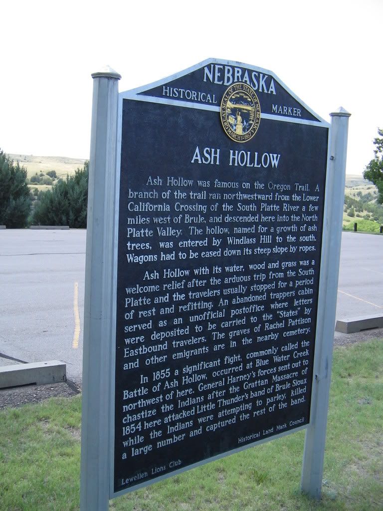
From Kearney until Ash Hollow, the golden age of the Overland Migration (1843-1860) goes unmentioned. What is marked at places near Lexington or Maxwell is of the later West. Roadside signs discuss Indian raids, violence, Pawnee scouts against the Sioux, and Buffalo Bill. The innocence of the early years of the trail is gone. But every Garden of Eden has its own sins.
Ash Hollow near present Lewellen, Nebraska was a place of peaceful rest along the trail. The trail briefly left the Platte River to go over some arid hills. The reward was a place of vegetation and water. Sioux Indians would camp along the valley during hunts. It quickly became a place of trade and interaction. Many emigrant diaries tell of how moccasins were highly valuable items to trade for. The Inidans clearly knew how to make better footware for walking across the Great Plains.
Ash Hollow is most famous for the Battle of Blue Water in 1855. The battle was between the United States Army under the command of Colonel William Harney and Dakota Sioux lead by Little Thunder. The prelude to the battle was in 1854 with the Gratten Massacre (to be discussed in the Fort Laramie post). After the massacre Little Thunder's band raided a few wagon trains and took scalps from some emigrants. Harney arrived from the East and instructed the various nearby Sioux to camp near Fort Laramie or be crushed. Little Thunder's band refused and camped near Ash Hollow. In 1855 Little Thunder was defeated and Harney marched on to Fort Pierre in a show of force against the Sioux. His actions so frightened the Sioux that it was nearly a decade before the next confrontation.
The battle is depicted in three different ways. A sign in the Ash Hollow parking lot reads in part:
In 1855 a significant fight, commonly called the Battle of Ash Hollow, occurred at Blue Water Creek northwest of here. General Harney's forces sent out to chastise the Indians after the Grattan Massacre of 1854 here attacked Little Thunder's band of Brule Sioux while the Indians were attempting to parley, killed a large number and captured the rest of the band.
The museum has a series of displays which goes in depth into the order of the battle and following events but merely says after the parley each side prepared for battle.
A few miles outside Ash Hollow is a roadside marker which reads:
On September 3, 1855, the U.S. Army's 600-man Sioux Expedition, commanded by Col. William S. Harney, attacked and destroyed a Lakota village located three miles north on Blue Creek. The fight became known as the Battle of Blue Water, sometimes the Battle of Ash Hollow after the nearby landmark, or the Harney Massacre.
The army's attack avenged the Indian annihilation of Lt. John Grattan's command near Fort
Laramie in 1854. Harney concluded the more than 250 Brules and Oglalas camped on Blue
Creek were the guilty parties. He divided his force and led his infantry towards the village. While Harney engaged in a delaying parley with Chief Little Thunder, the mounted troops had circled undetected to the north.
The infantry opened fire with its new, long-range rifles and forced the Indians to flee toward the mounted soldiers, who inflicted terrible casualties. Eighty-six Indians were killed, seventy
women and children were captured, and their tipis were looted and burned. This first, yet often
overlooked, military campaign against the Lakota kept the Overland Trail open, but only
postponed until 1863-64 a war between the two nations.
After Ash Hollow the Great Plains continue on. However, the Platte River begins to be flanked by natural wonders to the south and the sand hills to the north. The geography is changing.
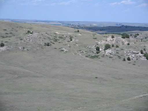
Trail ruts on a hill near Ash Hollow
Sunday, June 03, 2007
Along the Oregon Trail
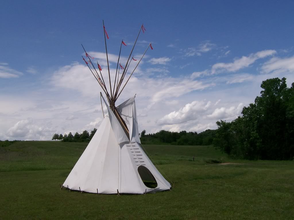
Dead tired after a few days along the Oregon Trail. Here's a picture of a teepee near Rock Creek Station, Nebraska. Will blog about this place tomorrow.
Saturday, June 02, 2007
Flags of the World by Color
 White and various shades of red are the most popular colors on flags. Thus making Canada, Denmark, Georgia, Indonesia, Monaco, Peru, Poland, Singapore, Switzerland, Tunisia, and Turkey the most average flags color-wise in the world.
Flags By Colours is a game which breaks down flags by color and makes a pie chart. Can you guess the flags by only a proportional pie chart? (Hat tip: TDAXP via Sean Meade)
Friday, June 01, 2007
Worst Town Names in the World
Catholicgauze's hometown is named after a village massacred by Indians. I cannot complain however because the name is innocent enough.
Other towns are not so lucky. Drivil.com has a list of the twenty-two worst town names in the world (obviously for the English-speaking mind). Among the unlucky few are Hookersville, West Virginia; Looneyville, Texas; and Fucking, Austria.
Other towns are not so lucky. Drivil.com has a list of the twenty-two worst town names in the world (obviously for the English-speaking mind). Among the unlucky few are Hookersville, West Virginia; Looneyville, Texas; and Fucking, Austria.
Subscribe to:
Posts (Atom)