Pages

Wednesday, September 30, 2009

Hawaii versus Hawai'i

For the last few years Catholicgauze has noticed an increasing use of the spelling of the fiftieth-state as "Hawai'i" instead of the standard "Hawaii." After a while of putting it off I decided to look into it.

Unlike other geographic confusions like England versus Great Britain versus the United Kingdom, Netherlands (Holland) versus the Netherlands, or nation versus state versus nation-state, this is a battle over the same place using a different spelling.

The choice of Hawaii or Hawai'i seemed to make no sense. The official seal of the state has "Hawaii" and "Hawaii" is also found all over the state's official website. Other state websites like the governor's use "Hawai'i" while the tourism department uses both.

Looking into why there is an apostrophe revealed something that does not surprises me: ethnic geopolitics. Both the English language and the missionary-inspired Latin alphabet for the Hawaiian language have the islands as "Hawaii." All documents dealing with the kingdom, republic, and territory have the spelling as "Hawaii." The same holds true for early documents of the state until the 1990s. However, in the 1980s 'Okina, apostrophes in words to stress sounds, was introduced into Hawaiian. Now, "Hawai'i" is preferred by ethnic Hawaiian nationalists who wish to stress the native aspects of the island. In a puritanical way they have adopted an invention to separate themselves not only from "outsiders" but also traditional Hawaiian culture. A cultural wave has supported the spelling of "Hawai'i" to emphasize the native, exotic quality of the state. The backers of "Hawai'i" have strong sway right now and are pushing hard for Hawaiians to be considered a native race like American Indians; giving them the power to establish race-based sovereign governments.

Now, to decide what is what. The US Board on Geographic Names, the government body in charge of deciding what a place's official name is, has declared the following.
  • The state is: Hawaii (made official by congress during entry into statehood, USBGN cannot change this)
  • The main island chain is: the Hawai'ian Islands (changed in 2001 from "Hawaiian Islands")
  • The big island is: The Island of Hawai'i (was Hawaii from 1914 until 1999)
  • The leeward islands are: Northwestern Hawaiian Islands (made official in 1987)

Tuesday, September 29, 2009

Interview with Dr. Reardon-Anderson of Georgetown University

Dr. James Reardon-Anderson of Georgetown University is making an effort to bring geography into his foreign service class. Sadly, some students oppose this move because they do not see the purpose of geography in the "Map of the Modern World Class." Not one but two Facebook groups have even been established to give voice to the protesters.

Dr. Reardon-Anderson has taken time out of his busy schedule and allowed himself to be interviewed by Catholicgauze. Here below are the questions and answers.

Catholicgauze: What convinced you to add geography to the Map of the Modern World class?
Dr. Reardon-Anderson: I have long believed that physical geography has been both important and neglected in the study of international affairs -- as well as other areas of human behavior. I consider this neglect a major short-coming of education at SFS (and other institutions of higher learning) and think it is time to introduce it into the curriculum.

CG: You have encountered some public opposition by students to the change. Why do you think that is?
DRA: There has been considerable negative reaction to the announced change in the content of the course, "Map of the Modern World." The reasons are varied. It is better to let the critics speak for themselves.

CG: Do you know of any other efforts by Georgetown to integrate geography into other classes?
DRA: I believe geography is included in some courses in the major on 'Science, Technology and International Affairs,' but not in other parts of the curriculum. That is why I have taken this initiative myself.

CG: What does geography mean to you?
DRA: The course in question focuses on physical geography, which include land forms, climate and the resultant life forms and their impacts on human behavior. This is a particular take on "geography" and does not represent the discipline as a whole.

I would like to personally thank Dr. Reardon-Anderson for taking time out of his day to be interviewed for this blog.

Geography Battle at Georgetown University

All Points Blog has a short blurb (below) about one professor's effort to introduce geography into a foreign service class at Georgetown University.

Map of the Modern World is the name of a course in the Georgetown School of Foreign Service. It's being reshaped per James Reardon-Anderson, director of the Bachelor of Science in Foreign Service program. The new version focuses on physical geography and its role in international affairs.

Per the school paper: "The changes will be embodied by three lectures on the fundamental forces that shape physical geography at the beginning of the course and a final lecture on global climate change. Reardon-Anderson, who will be teaching the class, acknowledged that the changes are part of the SFS’s effort to increase its students’ exposure to the sciences."

Students are not pleased. A protest group has sprung up on Facebook with more than 300 members. Some feel political issues will take a backseat to geography.
The blurb has a link to the Georgetown Voice article on the matter.

Clearly politics needs to have a very high perch in an international affairs class. However, too often these types of classes only do international politics. They ignore deeply powerful varables like physical geography, cultural differences which determine the end goals for various parties, religion, and so much more. If done correctly, Dr. Reardon-Anderson can open up many minds to the factors deeper than politics in international studies. Good luck to him!

Monday, September 28, 2009

Japanese War Propaganda Maps for Kids


Unlike Germany which called itself the Greater German Empire in World War II, the Japanese were much more media savvy in their endeavor. Calling itself the innocent sounding Greater East Asian Co-Prosperity Sphere, the Japanese never the less sought an empire run by ethnic Japanese and manned by national collaborates.

In the children's propaganda booklet Manifesto for Greater East Asian Co-operation maps and pictures were used to make the Japanese Empire look like an international effort of decolonization. The booklet say the Japanese are merely aligning themselves with Thailand (Thailand first allowed Japanese to enter it under force but then joined forces in 1942 because the king thought the Japanese were winning) to liberate the Philippines, Indonesia, China (from itself?), Burma, and India.

To accomplish this Japan set up an independent puppet state in Manchuria called Manchukuo, had several Chinese puppet states, established a Filipino republic, an Indian government, and a Burmese state. Later on Axis-on-Axis violence occurred in Vichy French Indochina and a Vietnamese puppet state was formed.

The maps are below (click to enlarge), showing a before and after look at what the Japanese wanted their children to think. Notice how there is no mentioning of China in the before map. Having Japanese fighting Chinese would defeat the desired narrative.


The Greater East Asian Co-Prosperity Sphere was destroyed and what it created ignored expect in the Philippines. In the 1960s, the nationalist President Diosdado Macapagal made Japanese-puppet President Jose Laurel's reign official so that Laurel is considered the third president of the Philippines.

Sunday, September 27, 2009

Water on the Moon

Several satellite programs, including the Indians' efforts, have given back data which scientists are now determining to mean that there is water in ice form on the Moon's surface.

Previously the Apollo moon missions gave the impression that the Moon's surface was completely dry. However, the astronauts only explored non-polar regions that receive plenty of sunlight. Around the poles the terrain is much more hilly and there are plenty of spots that are covered in permanent shade. Even where the Moon missions occurred there is evidence of some water ice underneath the surface.

While life as we know it cannot survive on the Moon the discovery of water is still important. Since water is so heavy and therefore hard to transport it was seen as a huge blocking point in lunar colonization. Now we have a vast amount of water available not only for human consumption but also things like lunar nuclear plants.

The new main problem is that water on the Moon is hardly what one can consider a renewable resource. The discovery; however, buys us time to figure out water transport/production issues while giving us a head start on possible exploration and other lunar economic activity.

All we have to do now is remember the economical benefits of lunar exploration. The Chinese, Indians, and other already have
. Now if only physical geographers would get into the act and help with mapping the water spots. Sadly, I fear only geologists will apply themselves to this important mission.

Saturday, September 26, 2009

Map of McDonald's in the United States


The blog Weather Sealed has mapped out all the McDonald's in the contiguous United States in a mission to find out where one can be the furthest from a McDonald's. The answer is western South Dakota. (Hat Tip: The Map Room).

When one looks at the map one sees how the eastern United States has McDonald's almost everywhere. This correlates with the population pattern. However, from the interior center into the Mountain West, McDonald's form a line that parallels the interstate system.

Two gaps noticeably appear in the map besides Western nonpopulation. The Florida Everglades and southern West Virginia. One's a national park and the latter is, well, mountainous and poor. Sadly West Virginia has frequently been overlooked by investors and businesses. McDonald's is no different.

Thursday, September 24, 2009

Poll: Where Should Catholicgauze Do Geography Next Year

Iraq was a blast. Now Catholicgauze has more choices on where I should go next (or I can just stay home). Vote and feel free to comment!

Where Should Catholicgauze Do Geography Next Year?
Afghanistan (Where the action is)
Kosovo (Safe, Euro Vacation... I mean work)
Iraq (Again)
Stay Home (Stateside)
pollcode.com free polls

American Retirement Guide Atlas: Looking Spatially for the Best Place to Retire

The economic resource Kiplinger has created an online atlas with information on where to retire. One can click various American states to see retirement information like tax rates and related information or choose to display things like the various states that have no income tax, no sales tax, and the most pension-friendly policies. While no brainers like South Dakota appear frequently on or near the top so does Washington state surprisingly.

If you are looking for senior-friendly and retirement-friendly places for yourself or a loved one be sure to take a look at Kiplinger's online atlas.

Wednesday, September 23, 2009

Mount Athos: The Orthodox State


In Europe countries like the United Kingdom and Norway have official religions but it generally thought that most of the population has somesort of post-Christian mindset. Only Vatican City is thought of as a truly pious country that is a theocracy when it comes to governance in Europe. However, in Greece there is an autonomous state that is run by monks, has a closed border where only men can enter if they have permission, and time is based on Old Testament teachings.

The Autonomous Monastic State of the Holy Mountain, also known as Mount Athos, is under the sovereignty of Greece but has full governance over its internal affairs. Religiously, the monks on Mount Athos are spiritually under the authority of the (Eastern Orthodox) Patriarch of Constantinople.

The permanent population is composed of twenty-one religious communities of monks and their security details. Only men are allowed to live on the Mount Athos peninsula. Some feminists and members of the European Parliament have tried to force Mount Athos to accept women visitors but the monk government claims that since God gave the area to the Virgin Mary as her own garden, no other women can be allowed in.

Unlike the rest of Greece, days begin on Mount Athos at sunset. This follows with the Jewish tradition as set in the Old Testament. Mount Athos does used the Revised Julian Calender which is the normal Gregorian Calender but keeps Easter on the traditional Orthodox/Julian Calender dates.

The first monasteries were established during Roman times, probably since the 300s. Later flow of monks from the Middle East and participation in Church councils prove Mount Athos importance in the 700s. The various monasteries were funded and supported by the Roman Emperors in Constantinople (Byzantine Empire). When the Ottomans seized Constantinople, the monks pledged support to the Sultan and in return the various Sultans taxed yet supported the monasteries as well because of the sultans saw themselves as defenders of both Sunni Islam and Greek Christianity.

In 1913 the first of various international treaties gave Mount Athos to Greece while recognizing Mount Athos as self governing. Also in 1913 the last Christian War (war based primarily on a Christian religious issue and not material gain) was fought on the peninsula. Russian monks on Mount Athos embraced the heresy of imiaslavie. This heresy taught that God's name was "God" and knowing this would give people magic powers. Several Russian gunboats escorted a Russian Orthodox bishop who tried to have the monks denounce imiaslavie. The monks refused so Russian marines stormed the monastery and took several monks parishioner.

Today the various monk groups range from traditional to radical in their beliefs. Several groups have repeatedly denounced the Eastern Orthodox Patriarch in Constantinople because of improving relations between the patriarch and the Roman Catholic Church. Patriarch Bartholomew I has responded with trying to evict radical monks for their disobedience.

Mount Athos has an official website
with a virtual tour of one of the monasteries. Meanwhile, Friends of Mount Athos has a website with information on how to visit the autonomous state.

If you have the time there is an informative but long documentary on Mount Athos below.


Monday, September 21, 2009

Dubai's World Islands Project Killed


View Larger Map
Not quite the final design as imagined

Dubai's World Islands project (official website) has been apparently killed off due to the economic downturn. It appears that there are too few buyers and it is too costly to maintain. Huge towers, palm islands, and more has made Dubai a modern day Babylon in some people's minds due to its material boasting. It appears the economic downturn and oil prices no longer at their highest of highs has made New Babylon run out of money. (Hat tip: The Map Room and Gadling)

All this can only mean one thing: it is Catholicgauze's time to shine. I have contacted the The World Islands project and sent an inquire to the United Arab Emirates' embassy to see if it is possible to buy a jar of sand or something on the cheap. Like any fallen civilization, the looters are already here.

Sunday, September 20, 2009

10 Geological Wonders You Didn't Know

Going around the internet is 10 Geological Wonders You Didn't Know. The website feature list ten geomorphic wonders with a picture of each and a short description along with a link. Featured sites include sand dunes turned into rock, a "gate to Hell" in Uzbekistan, and much more.

Saturday, September 19, 2009

New Map Blog Find: ¡Maps, mapas!

Catholicgauze has found a map blog of interest: ¡Maps, mapas! Mapas is a Mexico-based, Spanish language blog features historical maps series, modern digital atlases, and mapping news events. Even if one does not know Spanish, maps tend to be universal.

Friday, September 18, 2009

First Rock Planet Discovered Outside Our Solar System

Extrasolar planets (planets outside our solar system) have been known for a while now. In the past Catholicgauze has linked to an online, Star Trek-themed encyclopedia of extrasolar planets. However, in the past all known extrasolar planets were thought to be gas giants and not rocky planets like Earth. This has changed. Corot 7b has been discovered and is thought to be rock-based. The planet is five hundred light years away with a surface temperature of 2,700 degrees Fahrenheit (1,500 degrees Celsius)!

The linked article discusses the possibility of life being found on some rocky planet. The conversation is meaningless as far as I am concerned for several reasons. 1) It was no surprise that rocky planets are out there 2) Even if there wasn't rocky planets out there gas planets would be capable of having its own form of truly alien life 3) there are no religious qualms with life on other planets.

In the ancient Christian past, great minds like Saint Augustine of Hippo stated there could be no land outside of the European/Asian/African core. His geographical theology was shattered by the discovery of the new world. If there could be another hemisphere outside of the Jewish/Christian reach, why not whole worlds?

Thursday, September 17, 2009

Maps of places mentioned in books

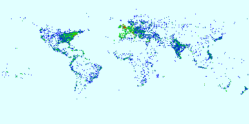
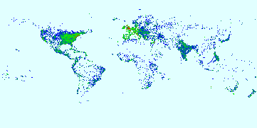
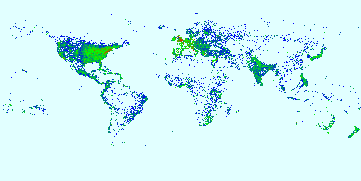
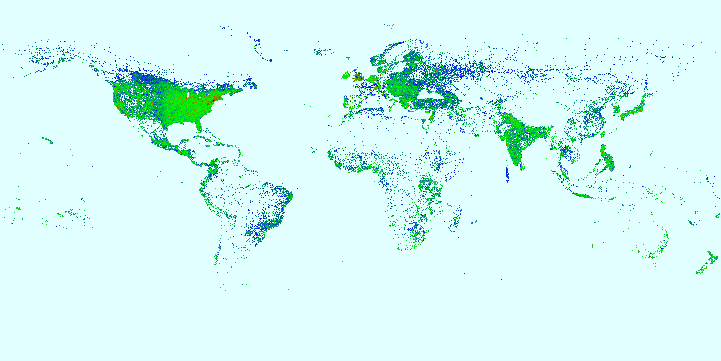
TDAXP twittered a link that shows the advancement of place mentions in, primarily Western, literature. Inside Google Books has made a code that maps locations in books and magazines that are featured in Google Books. The maps (below) show the advancement of geographic mentioning and therefore knowledge of places around the world. Be sure to note the correlation of imperial expansion and place mentioning.

1800

1830

1860

1890

Today

Wednesday, September 16, 2009

Skull Forces a Rethinking of the Human Exodus Out of Africa

The standard, accepted rise of man story consists of Homo erectus (proto-human aka hominin) being the first thing close to human to leave Africa around one million years ago. Homo sapien sapien (modern-man) later evolved into existence around 200,000 years ago and left Africa around 70,000 years ago.

However, scientists have discovered a hominin skull in Georgia, the country not the American state, that dates back to about 1.8 million years ago. The Georgian hominin is something that predates Homo Erectus. It is a smaller, dumber probable ancestor that likely used very basic tools similar to those of Homo habilis. At this stage of evolution habilis and the Georgian hominin look more ape-like than modern human.

The Georgian hominin may be evidence that Homo erectus evolved in Eurasia and not in Africa. However, if that is true something massive like climate change or alike forced humans out of Eurasia and back into Africa.

Regardless, the find is fascinating. Clearly we know only a small bit of our own history. Mapping the ebb and flow of migration and understanding the why behind it will answer old question but raise new ones as we try to understand just how man rose to the top of the world.

Tuesday, September 15, 2009

Venezuela Recognizes South Ossetia and Abkhazia, But Does It Matter

Back in August 2008, Russia recognized the breakaway republics of South Ossetia and Abkhazia. Russia hoped that a sort of counter-American (but not anti-American) alliance would also recognizes the breakaway republics to punish NATO and the United States. Instead only Nicaragua backed the Kremlin while the Hamas-occupational government of the Gaza Strip released a statement that may or may not have formally recognized the breakaway republics.

The situation became a bit of a joke. While the Republic of Kosovo has sixty-two states, not counting the Republic of China, backing its independence claim Russia could not rally any of its allies including Belarus which desires a form of reunification. Recognition from Daniel Ortega made it look like Russia could only command 1980s Communist throwbacks.

Now Hugo Chavez has granted recognition to the breakaway republics during his visit to Moscow. This gives Moscow and its satellites... another Latin American communist backer. While Kosovo gains more legitimacy everyday with non-first world countries joining first-world backers, Abkhazia and South Ossetia are still stuck with Russia and far left Latin American states. If these regions expect to separate themselves from Georgia in the eyes of other, they must show themselves of being free from Russian domination and seek recognition from countries who's governments are not run by jokes.

Monday, September 14, 2009

Norman Borlaug, Founder of the Green Revolution, Dead

For the most of history, famines were plentiful and caused by environmental fluctuations, pests and crop disease, and/or human mismanagement of either resources or population. Disease, mass migration, wars, and variety of other nasty things had their roots in the lack of food. Mankind was at the merciless sway of variables.

Norman Borlaug saved possibly over a billion lives by using science to help defeat these variables. Borlaug was an Iowan farm boy who received his education from life and the University of Minnesota. In the 1940s Borlaug began to develop species of wheat that could resist diseases and flourish in a variety of environments. His crops spread from Mexico to Pakistan then to Africa. While scientific doomsayers were saying that humanity was about to collapse due to overpopulation, Borlaug showed how science can readjust the equations. Today food crises are limited to ones that involve poor human practices (Ethiopian overgrazing) to authoritarian mismanagement (North Korea, Zimbabwe).

Reason has a great obituary for Borlaug. It is much better than one I could ever do. While some may harp on Borlaug for his Nobel Peace Prize and other awards, I think he should best be remembered for saving perhaps a billion lives. We will never know exactly how many lives would have been lost if it was not for Borlaug's Green Revolution... thank God.

Sunday, September 13, 2009

Royal Geographical Society's Booklet on Geography Careers

The British Royal Geographical Society has released a booklet about a dozen geographers and their career choices. The RGS has cast a wide net in talking about not only professional geographers but also geography graduates who have managed to integrate their studies into other fields. (Hat tip: Geography at About)

I have been particularly lucky in my geographical development. My father gave me a love of maps and history while my mother taught me how to read the story a map or globe tells. Besides academia, I managed to combine computers (I worked as a computer technician/trainer in undergraduate) and my geography education to obtain an internship at the National Geographic Society. After graduate school I was lucky enough to earn a professional position as a geographer. So far my two years has allowed me to study different concerns around the world with a four month tour to Iraq.

Only a few people are employed as a "geographer." However, many professions, some demonstrated in the booklet, combine elements of geography. Check out the booklet and see if there are ways you can bring geography into your position.

Saturday, September 12, 2009

JetPunk's Wide Range of Geography Quizzes

JetPunk has contacted me and demonstrated their wide range of geography quizzes they have online. Quizzes vary on scale and subject. Some are "which country is this" on a map while others are "festival x is held in what city?" I recommend the site for geographic training and amusement. Enjoy!

Friday, September 11, 2009

Maps of the 9/11 Terrorist Attacks

In honor of those who died serving themselves, their families, their friends, and their country. Rest in Peace

To add your story or to read others on a Google Street View Map click here (via Google Maps Mania). Another map shows the international loss of life caused by al Qaeda terrorists on September 11th.

Flight paths of the hijacked planes on 9/11 (click to go to interactive timeline)

Map of the Attack on the Pentagon by American Airlines Flight 93 (click to enlarge)


Map of American Airlines Flight 11 and United Airlines Flight 175's impact into the World Trade Center (click to enlarge)

Thursday, September 10, 2009

Online Choropleth/Outline Map Maker

This is a great find via geographyteach's Twitter feed. P&P World Map is an easy to use online program that allows one to draw, write, and color in an outline map of the world free of charge. Various labels and borders are toggleable and while I have not tried it, there is the ability to enter in statistical data. This is a must have tool for the amateur cartographer or blogger who needs a quickly made world map.

Wednesday, September 09, 2009

Switzerland: The Working Model for Afghanistan?

The most recent news about Switzerland is good economic news: the Swiss economy is judge to be more competitive than the United States'. A combination of smart, limited economic controls and a much more solid banking system has allowed the Swiss to reward capitalistic actions better than America.

While some underinformed observers may think of Switzerland as just another Western European country, it is very unique for that sector of the world. Decentralized government, functioning multiethnic population, and a conservative tint make Switzerland less like a Western European country and more like a working Afghanistan.

To understand how true this comparison is one must remember two things: 1) both countries are militaristic while practicing a form of isolationism and 2) Afghanistan was not always a basket case.

Membership in the Swiss military is mandatory and there are laws about citizens needing to own weapons. Meanwhile the average Afghan male knows how to use light weaponry with a fair chunk familiar with things ranging from heavy machine guns to anti-tank rockets. The Swiss have adopted a long and well known policy of neutrality. Meanwhile, Afghanistan has been concerned more about internal affairs and repelling foreigners rather than expanding its borders since the downfall of the Durrani Empire. The only exception is the Third Anglo-Afghan War in which the Afghans decided to go home after realizing it was impossible to rally themselves to invade Pakistan.

Since the establishment of a modern Afghanistan, meant to be a buffer between Russia and British India, there has been periodic turmoil but as the governments in Kabul became more established the less civil conflict there was. This is not to say Kabul ran the country, various local mayors and tribal leaders did, but everyone had a place and was generally content with it. During the first half of the Cold War both the USSR and United States gave aid to Afghanistan and help construct modern infrastructure. Social progression was very slow but an educated class was being developed. It was not till the Communist take over and the following Soviet invasion that modern Afghanistan became the war state it is now. This mirrors Switzerland where the various cantons have much more power than the central government in Bern.

There are some differences though that currently hamper Afghanistan becoming the next Switzerland.

Neutrality versus intervention

Various European powers have prized Switzerland for its neutrality. It has been a buffer between powers, a good meeting place for sides whose politics would prevent any other form of communication, and its banking laws have allowed states to realize its better to have an economic partner rather than a unwilling subject. Afghanistan has been a puppet, though throughout much its history. First the Persian, Russian, and British Empires fought to have advantage over each other by holding sway over Afghanistan. Then during and after the Soviet invasion Iran, Pakistan, and various Central Asian countries have favored factions in a long running civil war. The various factions would not have the funding, human capital, or weaponry if it was not for foreign funders.

Nationality

In Switzerland one defines themselves as a Swiss first then by their canton or their canton and then Swiss. Either way both the first choice and the second choice are usually nearly equal. Intra-national alliances are looked down upon. One alliance of German Catholic cantons was destroyed in a civil war by a united Catholic/Protestant alliance who feared the German Catholics were trying to unite against the rest of the country.

In the past Afghans were strongly tribal and ethnic divided yet rallied behind the idea of Afghanistan when foreigners threatened. The civil war has changed that. Now in the Pashtun south tribe is the most important factor with some ignoring Afghanistan and supporting a Pashtunistan that would unite parts of Afghanistan and Pakistan. Meanwhile the north is ethnic based with people identifying themselves as Tajik, Uzebek, or Hazara first while Afghan is a very distant second (or in the case of the Hazara a far third after ethnicity and political tribe).

How Afghanistan Could Work (Easier Said Than Done)

Afghans have tended to prefer a weak government in Kabul that can provide goods while leaving them alone to allow organic developments in society. Developing a democratic republican system that allows for tribal inputs with most of the control resting in local hands (much like the original intent of the American constitution) with a ethnically shared federal government like Lebanon could appease those who want strong local control yet still desire to have a say in national events. This would also prevent either a Pashtun bloc or everyone-but-Pashtun alliance from dominating the national government. After the anti-Communist forces took Kabul, many Pashtuns who previously cared little about Kabul became alarmed and anti-government because of the new non-Pashtun leadership. Political satisfaction increases when everyone feels they have input into both the local and national levels.

The big step to winning the peace is having Afghanistan's neighbors realize that peace is much more beneficial than war. Afghanistan has perfect geography because it can link oil pipelines in a way that avoids Russia and it can connect Central Asia to the Indian Ocean ports in Pakistan. Also, peace in Afghanistan help Iran and Pakistan return their Afghan refugees back home. The absence of terrorists would also help Uzbekistan, Iran, and Pakistan in ending their insurgency which use(d) Afghanistan as a safe zone.

Afghanistan is not Switzerland and will always have its own culturally unique traits. However, culturally acceptable divisions of governance and neighbors accepting a neutral Afghanistan that should not be unduly swayed could make Afghanistan a sort of Swiss-like state with limited central government control but peaceful.

Tuesday, September 08, 2009

Refugees Down, Internally Displaced Persons Up


The Economist has a good video on the latest developments in refugees (those who flee outside their country) and internally displaced persons (IDPs, those who flee but stay in their own country). The overall number of refugees are down; however, there are many more IDPs.

The reason for more IDPs is the turn towards internal, civil wars. There are now very few massive armies that sweep entire populations away from their homes. Now, much of the fighting is down by militia-like units which can only terrorize so much territory. This leaves many places in a country where there still is peace.

On the refugee front there is a negative trend growing. Many refugees do not want to go home. They have become use to aid and their new homeland (where they and other fellow refugees have created little national enclaves). This sadly can cause refugees to overstay their welcome like what happened to Zimbabweans in South Africa in May 2008. Either assimilation programs or an eventual boot-out is needed in these places. No one wants another Palestinian refugee situation where many refugees are forced into camps in neighboring states and feed hateful propaganda by everyone.

Saturday, September 05, 2009

The Strange Saga of a Geographer and a Weatherman

While I am enjoying Labor Day this story is too odd to pass up.

The great Geo Lounge links to the story of Dr. Melanie Renfrew and a Californian weatherman, Fritz Coleman. Apparently Renfrew was in violation of a restraining order by repeatedly contacting Coleman. Renfrew complaints was that Coleman was allegedly misusing the terms on-shore and off-shore winds. Coleman felt a restraining order was needed, which a judge granted, because Coleman believed Renfrew's behavior was unstable and threatening.

Dr. Renfrew has a blog which has her side of the story, namely the post entitled Is this North Korea, now? Renfrew claims she merely pointed out the error and Coleman was making something out of nothing.

The story gets a bit odd when one examines the blog posts Renfrew tried to delete. In one post she wonders who would play Coleman in a musical about the events. Another deleted post gives her side of the story as does a deleted public letter. A fourth erased post is terribly saddening yet oddly insightful. Renfrew may have cancer (prayers for her) yet it ends with
"I’ve lived life to the fullest, and want to bless others to do the same thing. I speak truth to set others free and laugh. “A merry heart is good like a medicine,” and cruel people hurt me very much." (Emphasis mine)
This story combines several elements of my own experiences. I know several good weathermen and a weatherwoman (yes, she does prefer that term) who have told me that they attract all sorts of weirdos who vent rage at people who are on TV everyday with a significant margin of error of being wrong. Meanwhile, some other geographers (myself included) have geographical pet peeves we hate to see including geographic inaccuracies. Sometimes we just have to let it go or risk mirroring this sad, odd story.

Friday, September 04, 2009

The Empire That Was Russia: 100 Year Old Photos of the Russian Empire


This Labor Day weekend Catholicgauze will be taking it easy and will return on Tuesday. Many readers will be traveling somewhere to celebrate labor and the last holiday of the summer. One place that can be visited this weekend is the long dead Russian Empire via Sergei Mikhailovich Prokudin-Gorskii's color photographs. The Library of Congress has the complete collection of photographs online in English and Russian websites.

The collection can be searched through or one can browse through various themes like buildings or ethnic diversity. Each photograph says a thousand words so be sure to think about what the image shows, what the backstory for the people and/or place is, and what eventually happened to them.

These photographs remind me greatly of National Geographic's golden era work.

Thursday, September 03, 2009

Why Knowing Language Matters: Chinese "River + Dike = Political Order"


"River plus dike equals political order" from here.

A key yet lost part of geography is the study of foreign languages. Sadly most advanced geography programs do not require study in another language. I personally feel insight into how a language orders sentences, forms phrases, and conveys action is just as an important sight into a culture as dress, diet, and even religion. I continue to believe my statement that language is the blood of culture.

Many people have heard the saying that in Chinese the word for "crisis" and "opportunity" is the same. This gives insight into why many Chinese do not see chaos as necessarily a bad thing but a potential positive as long as one acts properly.

During the People's Republic of China's (PRC) rise to development; damming of rivers and control of water sheds has been a primary goal of the government. While the government points out these projects help with industry and agriculture, some geographers and other scientists lamented the loss of ancient history to be forever drowned or looted. The common call was that the drive for development was blinding the PRC.

What one ignores when making this claim though is Chinese culture. Sure development played a majority role, but the language itself encourages control of the physical elements. Political order is a combination of the words river and dike according to one source. Another trusted online source translates political science as "water to arrange to bring joy." This helps explain China's near-Machiavellian drive to control its water (paraphrase of Machiavelli: water and women both need to be controlled).

The above can be thought of as triva. However, it helps explain why the average Chinese had the gut feeling instinict to support dam projects. The thinking was not conscience but subconscience. Only a detailed understanding of the Chinese language could help an observer understand that subconscience decision. This is just one small reason why the study of langauges is such a key part of a true geographic education.

Special thanks to TDAXP for his insight

Wednesday, September 02, 2009

What Languages Will be Important to Know?

Coming Anarchy has a great article which discusses what languages should people know/be taught in schools. Sure English is the new lingua Franca but serious scholars, business men, and travelers should know at least one other language (usually one that they deal with frequently). Not only does another language help with vocal communications but also gives an insight to the other culture.

Curzon makes three main tiers of languages to prioritize educational efforts. The tiers are below

Tier One
English
Spanish
Chinese
French
Russian

Tier Two
Arabic
Portuguese
Japanese

Tier Three
Turkish
Persian
Japanese

I generally agree with the tier system. I think Russian is going to greatly decline in demand as Russia continues to decrease in population and speaking it is more of a political statement in the Near Abroad (former Soviet states). Arabic is growing in importance and probably should rank above Russian; however, who knows if the Arab markets will adjust to a post-oil world.

Certainly the tiers of language have changed massive in recent history. This is probably the widest range of tongues of importance in Western history. Just think about it
  • Roman Empire to Early Renaissance: Latin and Greek were the only two languages of importance
  • Renaissance to Early 1800s: Latin fades as French becomes the only language of diplomacy
  • Early to late 1800s: English becomes equally important to French. Last few years see rise of German due to German scientific achievement.
  • Early 1900s to End of World War II: English, French, German
  • Cold War: English, Russian with Arabic and Chinese growing in importance. By the end of the era more second and third world languages become important.

Agree or disagree? Feel free to comment!

Tuesday, September 01, 2009

Russia: "Poland Wanted to Destroy Us! War was Self-Defense"


On the seventh-anniversary of the start of the European-theater of World War II, Russia has decided to not to feel the world's pain but instead go out of their way to claim The Second Polish Republic wanted plotted to destroy the innocent Soviet Union.

As noted before, Russia is very upset that their legacy of being liberators is being challenged by those nations who simply switched from National Socialist-occupied to Communist socialist-occupied. Poland, the Baltic states, and Ukraine all have gone to various degrees to point out that Soviets killed more than the Nazis in some places. Russia is fighting back with proposed "historical accuracy" laws and even cyber-warfare.

I personally doubt there were any serious plans by Poland to have a Franco-German-Polish alliance that would take down the Soviet Union. However, if there was, Poland would have good reason. The USSR had already invaded Poland once and this was after the Communists had invaded other countries like newly-independent Ukraine, the ethnic republics in the Caucasus, and they tried to overtake the Baltic states as well.

Sadly, the Putin regime in Moscow continues to assert Russia as the successor state to the Soviet Union in all the wrong places. Unlike Yeltsin who tried to divorce Russia from the Communists, it seems Russia will be doomed to repeat its past as the Bear on the fringe of Europe.

Nazi Pseudogeography

The National Socialist German Workers' Party (Nazi) had an extensive plan for world domination not only in political-military matters but also in more odd subjects. A cosmology was envisioned by some of the top Nazi leaders. Part of this mad world involved a complex pseudogeography. Two key elements of the worldly pseudogeography (ignoring astronomy) were a hollow Earth and the Thule-Aryan connection.

Hohlweltlehre

Nazi pseudogeography borrowed heavily from Norse mythology and Tibetan folk beliefs. The pagan Norse believed in a world below ours where really evil dark elves lived while the Tibetans thought that the Earth had openings to worlds below where one's soul could achieve nothingness.

The Nazis, thinking themselves enlightened, rejected the supernatural elements of these beliefs while clinging to the hope that there were worlds inside the Earth. Hopeful the worlds would have easily reachable resources and having Aryans or easily conquerable people living below certainly would have been a plus.

While the Nazis did claim a section of Antarctica, New Swabia, there was no expedition there to find a hollow Earth. There is some evidence that the Nazi Tibetan expeditions were looking for portals but only the most die-hard occult Nazis thought it was possible to locate one.

The plan to conquer the hollow Earth never left the fleeting minds of the mad men who thought it up.

Thule Equals Aryans Around the World

Holding slightly more weight in Nazi pseudogeography. The Nazis were genuinely interested in researching their supposed Aryan heritage with organizations like the Ahnenerbe. Portions of the society though were infected with the thoughts of the occult Thule Society. The society believed Aryans did not some tan browned-skeined, brown haired people but were in fact blonde haired, blue-eyed whites from Atlantis! After the Aryans managed to lose Atlantis they fled to the lost land of Thule, the society believed. Once on Thule the Aryans supposedly left and easily settled across the world while the rest of humanity was living in the Stone Age.

The Nazis in general believed that an Aryan people once roamed over a wide section of the Earth. The Ahnenerbe supported this belief by pointing out that Far East people like the Kalash and Ainu had Nazi-prized Caucasian features. Research trips to places like Tibet sought to further back-up the Nazi's point of view. The Nazis failed to anticipate the discoveries in genetic geography that mapped human expansion out of Africa which links all humans together. Also, Caucasians flowed both ways, into Europe and into Asia. It was in Europe where the race fared better against Turkic and other groups.

Final Note

The Nazis had much more down to Earth views that did far more damage. However, a pseudogeography in particular and a whole range of pseudoscientific thoughts were created and used by the Nazis to justify policies that lead to tanks rolling and people dying.