Online geographers are keeping busy as yet another war in the Middle East breaks out. A Google Earth user only known as "IsraelForiegnMinistry" has released a KML file that shows Hamas rocket impact sites in Israel around the Gaza Strip. The file can be viewed on Google Maps or the KML can be downloaded for Google Earth. Date is appears up to date as of December 31, 2008.
While the Israeli Defense Force has started their own YouTube channel I doubt this is a public release from the Israeli government. However, it is a sign of the times how neogeography is using the tools of the information age to quickly convey geographic data. This reminds me of my Russia-Georgia War maps for Google Earth and Google Maps.
In the future I hope for better sourcing of data (something I am guilty of) and a community effort to perfect products. Anyone who is interested in something like this feel free to contact me so we can work together.
Wednesday, December 31, 2008
Kunyas: Nicknames that are Names
Catholicgauze writes in and discusses the lack of a proper naming system in the Middle East.
You may or may not know the word "kunya" but in one way or another you probably have already heard of a kunya. Educational materials on Arab culture or the Middle East will teach you that kunyas are honorific names/titles used by Arabs. What is generally taught is that someone named "Abu Umar" is the father of a child named Umar. "Umm Umar" would be the mother of Umar. Meanwhile an Ibn Thahr is the son of a Thahr.
All Catholicgauze can say is that is how the system was meant to work but no longer does (or in my sleep-deprived thinking, "Lies! Horrible Lies!). In today's modern Middle East the kunya has devolved into nicknames that can be used in place of true birth names on almost anything expect official government documents. People will take a kunya to tie themselves with popular historical figures, their profession, even favorite sports stars.
What is truly something else is one can have a kunya for certain situations. For instance, your friends may know you as "Abu Ahmad" after your son but your your co-workers may know you as "Abu Jindal" after the local soccer star. Surprisingly your family may not know you use the kunya Abu Jindal. So a co-worker could call your home, ask for an "Abu Jindal," and be told no one by that name lives there. Your co-workers may not know your true name so any attempts to reach you would end in vain right then and there.
Catholicgauze has encountered this problem already and plans on many more name searches. I can only imagine how people who live in the Middle East manage to work around this kunya problem.
Monday, December 29, 2008
Classic Gauze: Mormon Geography Battle
Nothing can make control of place more heated then when religion is involved. When people believe God tells them that the land is there. Look at the battle over Jerusalem in general or Eastern Orthodox versus Armenian Orthodox over who can lite candals at the Church of the Holy Sepulcure.
A low-intensity, realitively unknown religious place battle currently goes on in Independence, Missouri. Three branches of Mormonizism fight for control of the Temple Lot, a place where they believe the Garden of Eden was and where Jesus will return.
-------------------------------------------------------------------------------------
Originally published September 20, 2007

Top left of the intersection: Community of Christ Temple
Top right of the intersection: Latter Day Saint Museum
Bottom right of the intersection: Community of Christ auditorium of Community of Christ
Bottom right: House is the headquarters of Church of Christ Temple Lot
Geography plays a big role in religion. The whole concept of a "holy land" brings the cosmos onto Earth. For many the holy land is the land in and around the country of Israel. For others the holy land extends down into Saudi Arabia. For Mormons there is another holy land. This one is located in Independence, Missouri and known as the Temple Lot.
The Temple Lot is a hill to the west of downtown Independence (presently a eastern suburb of Kansas City, Missouri). It is here where Mormon founder Joseph Smith Jr. declared the spot of the Garden of Eden and where a temple would stand that Jesus Christ would visit during his second coming.
Smith intended western Missouri to be the home for Mormonism. However, the New England "bloc" living Mormons were outcasts in an individualistic, slave-owning Missouri. Tick-for-tat terrorist raids on both sides followed up by an extermination order from the governor of Missouri forced the Mormons out and into Illinois.
The importance of the Temple Lot was not lost; however. Mormon theology still teaches Jesus will visit a temple on the grounds. Therefore a temple must be built. Splits in Mormonism have complicated this. Three branches of the religion claim property on or near the lot.
The Church of Jesus Christ of Later Days Saints (LDS aka Utah Mormons aka the biggest branch of Mormonism) have a visitor center for historical tourists and the headquarters for their local bishops. The LDS does a good job keeping the history of itself in people's minds and on the landscape.
The Community of Christ (CoC) has its own temple. The CoC's presence is reflective of its relationship to LDS. The CoC split off from LDS after the death of Joseph Smith Jr. The CoC rejected what they claim were inventions by Brigham Young and brought the church closer in line with mainline Protestantism. The temple is open to all (unlike LDS temples) and dedicated to peace throughout the world. Inside everyone is welcomed to take a self-guided tour which one symbolically receives all the CoC's sacraments.
The final player is the Church of Christ Temple Lot. Temple Lot believes that towards the end Jospeh Smith lost his way and his last prophesies were false. This group has tried repeatedly to build a temple but has been delayed because of economical downturns, legal challenges, and arson. The Church is small in membership and does not have relations with any other off-shoot. There small building is a monument to their isolation.
Saturday, December 27, 2008
The Socio-Economic Hierarchy of Iraqi Salesmen
Catholicgauze writes from Iraqi describing his thoughts on salesmanship
"Hello my friend!" "Yes, yes, yes." "Please come in."
Those words I hear often. Fortunately for me I now have a good reputation so the words now have meaning behind them, but every American who visits an Iraqi shop is likely to hear that. After hearing these words and seeing the various shops many times, I noticed there is a hierarchy of salesmen. This hierarchy correlates with the status of the Iraqi and reflects how the average American will view the seller.
Common Iraqi
Who: Anyone but tendency towards older couple, sometimes women
Goods: General, things found in the household
Where: Anywhere, sometimes along roads
Common Iraqis were the first to sell to Americans. These people simply set up a table and displayed all their stuff on a blanket. They offer nothing fancy but in their supply of plates, homemade blankets, etc. are a few pieces of gold jewelry, small handmade furniture, and old Iraqi army equipment. Common Iraqis speak little to no English but can communicate the necessary "ten dollars" and "thank you."
Iraqi Salesman
Who: Moderately educated person with a supply chain
Goods: Things like flags, blade weaponry, electronics, and ornamental goods.
Where: The skillful ones are found on American bases
The Iraqi salesman has thousands of years of Arab trader culture in his blood, a good supply chain, and a decent command of English. They can be very talkative and friendly if one wants to start a conversation. Iraqi salesmen frequently go on month long trips to American bases and send the money back home. Many have worked with both the American military and Iraqi government to allow shops to be placed on bases. Unfortunately, groups like Al Qaeda in Iraq hate these people as collaborators and I have heard of a few who were murdered in the past.
Iraqi DVD Pirate
Who: Younger males with Internet access and a DVD burner
Goods: DVDs of movies, television shows, and documentaries
Where: American bases
Want to see Twilight but you are over 1,000 miles away from an English movie theater? Need a 2001 National Geographic documentary? Well, if the Iraqi DVD Pirate does not have it, he can go online and burn you a copy for five dollars. These pirates work in groups and will live on bases like Iraqi salesmen. Most have a fair understanding of English but have a great knowledge of [American] pop culture. Trustworthiness is determined by Americans by the basis of the DVD's quality. Some are poor video camera feed while others were produced by professional equipment in a movie theater. The best quality is the straight DVD rip. There are legitimate American DVDs for sale on base but those are full price. The Iraqi DVD pirate is the unchallenged master of his field.
Iraqi Seamster [tailor]
Who: Iraqi (and some Indian) men with knowledge of the sewing machine
Goods: Anything that can be sewn
Where: American bases
Iraqi sewers have broad appeal with a higher priced product. Want an Iraqi flag with your name and dates of service on it? Sure thing! Want backpack with military camouflage and your favorite football team's logo on it? No problem. These men show that there is profit and no shame in male sewing. They work in groups with only one person who needs to know English. Some Indians have come over as well to earn money with their skills. Officers, group leaders, and the memento seeking enlisted man are all primary customers of the Iraqi seamster.
The Turks
Who: Turkish traders
Goods: If it is expensive, they have it
Where: American bases
The Turks are an outsider but they are on top of the hierarchy. Leather coats; $500 handmade marble chess sets; jewelry; and fine carpets are their goods. The Turks occupy a sort of mixed ground. They have the Middle Eastern background but many would be best defined as European based on their clothing (especially the liberated women). Some Turkish stories have Iraqis who help the customers look for things while the Turks handle the money. Every American who is on a base knows that when one goes shopping at the Turkish store, one wants to buy some fine gifts.
Monday, December 22, 2008
Merry Christmas 2008
I may be in Iraq but that does not mean I miss my father's Nativity set now by the fireplace

Unto us a child was born who would redeem and save humanity. Let us remember his life and his many messages. Peace be upon you and the world.

Unto us a child was born who would redeem and save humanity. Let us remember his life and his many messages. Peace be upon you and the world.
Sunday, December 21, 2008
Czarists v. Kaiserites!
Via Strange Maps, this incredible electoral map of Poland superimposed on the 1914 borders of Imperial Germany and Imperial Russia

The gnxp thread has some good observations. Anyone know how this map squares with post-WWII resettlement patterns?
The gnxp thread has some good observations. Anyone know how this map squares with post-WWII resettlement patterns?
Thursday, December 18, 2008
Rat Map of New York City
The interface seems designed to frustrate me, but Eddie points me to New York City's rat map, along with an article in Time describing it.
Personally, I think rabbit is the most delicious rodent.
Personally, I think rabbit is the most delicious rodent.
Wednesday, December 17, 2008

Monday, December 15, 2008
Snow Rollers!
The Keloland blog has a post about snow rollers in South Dakota.
Some more info on snow rollers, from Wikipedia:
At least they weren't making mysterious quacking sounds!
Some more info on snow rollers, from Wikipedia:
A snow roller is a rare meteorological phenomenon in which large snowballs are formed naturally as chunks of snow are blown along the ground by wind, picking up material along the way, in much the same way that the large snowballs used in snowmen are made.
Unlike snowballs made by people, snow rollers are typically cylindrical in shape, and are often hollow since the inner layers, which are the first layers to form, are weak and thin compared to the outer layers and can easily be blown away, leaving what looks like a doughnut or jelly roll. Snow rollers have been seen to grow as large as two feet in diameter.
At least they weren't making mysterious quacking sounds!
Classic Gauze: Geography Books of Evil
Reading geography books is fun. One not only knows about the world but also can use the book as a looking glass into the world view of the author and the author's culture. American textbooks relate things to the United States while Nigerian geography books focus on Africa and the influence of Europeans.
The Nazi and East German books featured in Geography Books of Evil not only teach geography but focus on the superiority of their systems. The Nazis killed eleven million in their camps (not to mention the millions on the battlefield) while Communism is well into the 100+ million. Examine the worldviews and compare it to yourself.
---------------------------------------------------------------------------------------------
In research class yesterday I read social geographers criticisms of GIS. One of the charges was that GIS is "evil" because it was "partly funded by the military." I'll put up a scan latter. I was floored by this claim of "evilness" in Geography. The fact that the claim came from a field of geography infested by Marxists only made me more dumbfounded.
So I wondered if I could find any really evil Geography. Then, like a sign from above, the German Propaganda Archive from Calvin College provided everything I needed.
First up are excerpts from a Nazi Geography book. The book rants on how Germans "need more space." The classic Nazism in this book is:
- Our development into an industrial state dependent on world markets was intensified by the economic losses resulting from the dictates of
The second evil book is a civics book from the Democratic Republic of Germany (
Maybe the East Germans weren't completely evil. The third book explains why it was good for
Category: Books
Friday, December 12, 2008
Under the Full Moon
[Editor's note: Catholicgauze emails from Iraq...]
The moon is closer than it has been in the last fifteen years due to its elliptical orbit. Combining this with the fact that it is full and the sands of Iraq here are white makes tonight a very bright one. I have done a bit of walking in between briefings and it is the first night here that I have not needed a flashlight. Usually the dead of night is pitch black, truly black. However, now I have a long range of sight and can even make out a few colors that are usually lost to night's overriding hue. Many stars are also blocked out in the moon's light pollution. Orion is still visible as he crosses the night sky and so are a few meteorites. It is very still out here. Almost no sounds what so ever. Just me and the wind in the leaves of the tropical trees.
The moon is closer than it has been in the last fifteen years due to its elliptical orbit. Combining this with the fact that it is full and the sands of Iraq here are white makes tonight a very bright one. I have done a bit of walking in between briefings and it is the first night here that I have not needed a flashlight. Usually the dead of night is pitch black, truly black. However, now I have a long range of sight and can even make out a few colors that are usually lost to night's overriding hue. Many stars are also blocked out in the moon's light pollution. Orion is still visible as he crosses the night sky and so are a few meteorites. It is very still out here. Almost no sounds what so ever. Just me and the wind in the leaves of the tropical trees.
Thursday, December 11, 2008
Unemployment rate by US State
 Screen Shot of MSNBC's Interactive Unemployment Rate Map
 September 2007-present
MSNBC has an interactive map displaying the unemployment rate by month for each State, starting with September 2007 up to present day. You can scroll around, or let it play, to see the timeline progress.
Wednesday, December 10, 2008
Christmas 2008: Why It Did Not Happen Now
Arab Tribesman: **Arabic**
Translator: He says some camelmen came across the border and are
eating his sheep's grass.
Field Analyst: I better alert the task force. (Grabs Radio) Task
Force, this is ground. Got some fast movers coming across my grid.
Task Force: Roger, sending up a Predator UAV now.

(In Task Force HQ - Giant TV screen shows Predator feed)
Analyst 1: Sir, looks like we got a camel convoy coming across the Euphrates
Commander: Better send a ground assault force.
(Later an assault force meets up with the convoy)
Soldier 1: Halt, identify yourself.
Wise Man: We are Wise Men from the East.
Soldier 2: What are you doing here?
Wise Man: We are on our way to meet our Savior.
Soldier 1: Better get on the horn, we got some Mahdi freaks. What do
you have here?
Wise Man: Gold, frankincense, and myrrh
Soldier 2: Where are you going with these goods?
Wise Man: To Bethlehem.
Solider 1: (On the radio) Command, we got some Iranian Mahdits on
their way to give supplies to Palestinians. Request orders.
Radio: Detain them.
Translator: He says some camelmen came across the border and are
eating his sheep's grass.
Field Analyst: I better alert the task force. (Grabs Radio) Task
Force, this is ground. Got some fast movers coming across my grid.
Task Force: Roger, sending up a Predator UAV now.
(In Task Force HQ - Giant TV screen shows Predator feed)
Analyst 1: Sir, looks like we got a camel convoy coming across the Euphrates
Commander: Better send a ground assault force.
(Later an assault force meets up with the convoy)
Soldier 1: Halt, identify yourself.
Wise Man: We are Wise Men from the East.
Soldier 2: What are you doing here?
Wise Man: We are on our way to meet our Savior.
Soldier 1: Better get on the horn, we got some Mahdi freaks. What do
you have here?
Wise Man: Gold, frankincense, and myrrh
Soldier 2: Where are you going with these goods?
Wise Man: To Bethlehem.
Solider 1: (On the radio) Command, we got some Iranian Mahdits on
their way to give supplies to Palestinians. Request orders.
Radio: Detain them.
Biking in Iraq
Problem: There is point A where I am at. Then there is point B which is too far to walk.
Solution: Bike it.
I got a bike and now I can go on the hardened sand surfaces of Iraq. The thin, white layer of powdery sand is not a problem as long as I go fast enough. I was so excited when I got the bike because I love cycling so much and its a great chance to see the outdoors. Nature on the other hand was not so cooperative. First it started to rain in the desert. Not too hard but the white powder became a thin layer of mud. However, it was still ridable and the bike has mud guards over the wheels. Then, a cold front with wind came. It is a cold night in the lower fifties with the possibility of upper forties. Good thing there was rain otherwise I could be outside in a cold duststorm.
Tuesday, December 09, 2008
Corruption Perceptions Index 2008
 CPI 2008
Today is International Anti-Corruption Day.
Every year the NGO Transparency International (TI), releases their Corruption Perceptions Index (CPI) that measures the perceived levels of public-sector corruption.
While you can take a look at their handy chart, their CPI world map (above) is likewise also very useful.
Some findings include:
- Corruption in Russia is at a 8-year peak,
- South Korea improved significantly than past years,
- While Western European countries rank highest on the CPI, there is a decline among their scores,
- Croatia, Macedonia, Montenegro, Serbia and Bosnia and Herzegovina have not improved significantly despite reforms from the EU pre-accession process.
Monday, December 08, 2008
Geography at the Nobel Prize Ceremony
There is a firestorm over comments made by Paul Krugman (this year's Nobel Prize winner in Economics, a New York Times writer, and normally a reliable liberal) that the the US automakers will disappear:
On his blog, Krugman clarifies that he means the Detroit auto industry will disappear -- it will be just fine in other partys of the country.
Krugman's remarks were not off-the-cuff, but come from his presentation that discusses economic geography - here are two of his slides (links from Krugman's blog and Marginal Revolution):

Over at tdaxp, I note Krugman's argument that higher oil prices can decrease oil supply, as well as Krugman's call for public investment.
"It will do so because of the geographical forces that me and my colleagues have discussed," the Princeton University professor and New York Times columnist told reporters in Stockholm. "It is no longer sustained by the current economy."
Krugman won the 10 million kronor (US$1.4 million) Nobel Memorial Prize in economics for his work on international trade patterns. Some of his research on economic geography seeks to explain why production resources are concentrated in certain locations.
On his blog, Krugman clarifies that he means the Detroit auto industry will disappear -- it will be just fine in other partys of the country.
Krugman's remarks were not off-the-cuff, but come from his presentation that discusses economic geography - here are two of his slides (links from Krugman's blog and Marginal Revolution):
Over at tdaxp, I note Krugman's argument that higher oil prices can decrease oil supply, as well as Krugman's call for public investment.
Classic Gauze: International Baseball Realms
Baseball is an American game that has spread throughout different regions of the world. Each realm has its own history and style. The hybridization of baseball mirrors the hybridization, or "corruption", of universals in the process of globalization
-------------------------------------------------------------------------------------------
Originally published June 28, 2007

The Cores and Peripheries of World Baseball
Professional baseball has expanded into Israel. The Israel Baseball League hosted its first game as the Modi'in Miracle crushed the Petach Tikva Pioneers nine to one. Israel joins the international baseball community with this modern reintroduction of the sport. Baseball was frequently played in Old Testament Israel but lost favor with Saint Paul's career in NASCAR.
Israel now joins the international world of baseball. Baseball's distribution can be broken down into three core and three periphery zones.
The historic home of baseball is the American Core. Baseball evolved from the British game of rounders. Throughout the 1700 and 1800s the game was played with a variety of rules until "Knickerbocker Rules" became the basis of the modern game. Today the American core is comprised of the United States and southern Canada. Baseball once was the major national sport in America but has lost out to football.
The Hispano Core has historic ties with the American Core. Cubans played baseball as early as the 1860s. The game was played by American sailors and Cubans who were schooled in the United States. Baseball was even viewed as a threat by Spanish authorities who viewed it as a protest against Spanish cultural traditions like bull fights. Emigration from Cuba during its revolution brought the game to the Dominican Republic. Cultural interaction with the United States brought the sport to Panama, Mexico, Venezuela, and Puerto Rico. Many Major Leagues play in the Hispano Core's winter leagues. Recruiting by the Major Leagues is heavy in the Hispano Core.
The Far East Core has a history as long as the Hispano Core. Professor Horace Wilson brought Baseball to Japan in the 1870s. The game slowly gained popularity. Before World War II, Major League Baseball players traveled to Japan in order to play in exhibition games and operate sports clinics. Baseball was viewed negatively in Korea because of its Japanese popularity. The permanent stationing of American military reintroduced the game. Today Japan and South Korea are bitter rivals whose players are being scouted by the Major Leagues. The Far East Core proved its worth with Japan's victory over Cuba in the 2006 World Baseball Classic.
The Far East Periphery is an area where baseball is growing in popularity. Taiwan received baseball from Japan but the game was long viewed as a child's activity. Taiwan is a major player in the Little League World Series. Professional baseball started in the 1980s but has been greatly damaged by game fixing scandals. The People's Republic of China has recently picked up baseball. This is partially due to China's effort to dominate sports.
The European Periphery got its start from American military after World War II. Many of the first teams were actually formed by Americans who recruited locals to fill in spots. Russian soldiers have recently begun their own minor leagues with slight expansion into the general public. Italy and the Netherlands are so far the only countries of note. However, there are efforts to improve European baseball in time for the next World Baseball Classic. Wales is an active center of "British Baseball" which can be thought of as 75% baseball 25% cricket.
The Down Under Periphery comprises both Australia and New Zealand. Baseball is weak here but there are efforts to reestablish a league. Cricket is viewed as the proper sport and has so far been successful in keeping baseball minor. However, the success of the Australian women's softball team in the Olympics has increased interest with women. Australia now has a woman's baseball team which has earned respect in international competitions.
Friday, December 05, 2008
Attackers used Geography tools; technology to disguise geographic orgins
On Wednesday, the front page of the Washington Post published a story, "Gunmen used technology as a tactical tool: Mumbai attackers had GPS units, satellite maps."
The author writes that the attackers set sail from Karachi, Pakistan to Mumbai, India using GPS navigation tools and detailed maps, as they were not experienced sailors. They also used high-resolution satellite maps to understand the city's layout and buildings before they arrived there.
Something else that I find interesting is that the organization claiming responsibility produced the email (their announcement) used a Urdu voice-recognition software to '"anonymatize" regional spelling and accents so police would be unable to identify their ethnic or geographic origins.'
While these terrorists used common technology tools that are easily available, India's police still use World War II-era rifles and Indian security forces lag technologically behind.
This continues the trend of geographic technology being used for the wrong reasons.
Monday, December 01, 2008
Indiana Jones Denied Tenure
Something to break up Classic Gauze
A dream of all geographers is to travel for academic research or job-related reasons on someone else's bill. Academic geographers, especially the ones at richer schools, can pull this off via grants. Another dream is to be the geography-equivalent of Indian Jones. Finding Nazi gold with lost maps, getting the girl, and adventure all are embedded in our DNA. Combine these two dreams together and one has a bad case of day dreaming Catholicgauze-style.
Well, this can come at a cost. Indiana Jones was denied tenure.
Friday, November 28, 2008
Catholicgauze makes it to Iraq
Hi everyone! I managed to get to Iraq safely. I am now exploring what little bit of the desert environment I can. The Walis, dryriverbeds in Arabic, are really neat to see. These things are dozens, if not hundreds, of miles long and can stretch to well over a milewide. Nights can get cool but not yet truly cold. Meanwhile the days are not that bad since they only get up into the 70s. I will try to write more later, but I just wanted to keep you informed.
Thursday, November 27, 2008
Becoming an American: identity and geography
With Thanksgiving this week, NPR has been “spending time thinking about what it means to become an American” during the "most American" of holidays. Yesterday, author Joseph O'Neill (raised in Holland, half-Irish, half-Turkish, now living in New York City) spoke about identity and geography.
O'Neill's view is that in this age of globalization, migration as we knew it (Irishmen coming to the US due to a potato famine and never returning home) has changed. It's easier to travel, speak on the phone or use electronic means.
NPR paraphrased him well saying that of Americans, people are less inclined to make judgments based on race or class – but also not particularly interested in learning about his background.
[Maybe that's perhaps another reason why Americans don't know geography.]
Happy Thanksgiving!
Monday, November 24, 2008
Picturing the Past
Catholicgauze requests that I note this story on La Cartoteca about "HistoGrafica - Picture the Past." HistoGrafica allows users to look at photos of a place through time -- kind of like a PhotoSynth of the Ages.

For one of the more depressing contrasts, compare the Omaha's Kountze Park in 1898 with the ghetto firing range that it's become. It reminds me of the decline of Fort Totten, DC.
For one of the more depressing contrasts, compare the Omaha's Kountze Park in 1898 with the ghetto firing range that it's become. It reminds me of the decline of Fort Totten, DC.
Classic Gauze: Official Languages of the United States
America is a diverse country that so far has managed to unite as one. There has been many pushes to have English be the official, uniting language of the United States in this era of high legal and illegal immigration. However, many states already have official languages. Most of these are English but depending on the cultural background of the state there may be others as well.
Since the publishing of this classic post New Mexico has moved even closer to bilingualism (English and Spanish) while still not having an "official" languages law.
------------------------------------------------------------------------------------------------
Published Friday May 19, 2006

Since the publishing of this classic post New Mexico has moved even closer to bilingualism (English and Spanish) while still not having an "official" languages law.
------------------------------------------------------------------------------------------------
Published Friday May 19, 2006
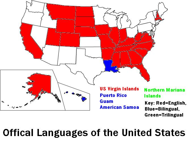
The United States Senate voted recently to make English the official language of the
Twenty-six states and the Virgin Islands all have English (American version) as their official language. There has been controversy; however.
Some parts of the
- Puerto Rico is officially English and Spanish but Spanish is the unofficial primary language.
- Guam has both English and Chamorro. Many young know little of Chamorro and Japanese is an unofficial language used extensively on
- American Samoa recognizes English and the native Samoan
- The Northern Mariana Islands is trilingual with English, Chamorro, and Carolinian
There are outliers with these facts too.
If English does become the official language of the
----------------------------------------------------------------------------------------------
What type of American English do you speak? Find out with Yall Tock Funny Ya Hear
Want to find out the difference between American English with that from the motherland and Australia along with Cajun versus Fromage? Find out with Figjam
Friday, November 21, 2008
Genetic Map of Europe
Courtesy gnxp, this genetic map of Europe:

Read the original paper for more details, but for me the interesting thing is that the Russian race (like Russian culture, or the Russian state) is only marginally European. Of course, the Great Russian Die-Off will change the features of those Russians that remain in a generation or three.
Read the original paper for more details, but for me the interesting thing is that the Russian race (like Russian culture, or the Russian state) is only marginally European. Of course, the Great Russian Die-Off will change the features of those Russians that remain in a generation or three.
Thursday, November 20, 2008
Geography Awareness Week 2008: Is it working? A look back.
Geography Awareness Week was designated by Congress in 1988 to combat ignorance.
I stumbled on a 1992 New York Times article in honor of Geography Awareness Week titled “Redoubling the Efforts at Teaching Geography.” It cited a 1988 Survey of Geographic Literacy stating that 25% of young Americans, 18 to 24 years old, could not find the Pacific Ocean on a map. This got me thinking: what has happened since? Thankfully, NG has continued the study in both 2002 and 2006. Catholicgauze happened to comment on the 2006 survey results, too.
It's interesting to see the trends and compare results over time of young Americans. I'm trying not to bombard you with statistics, so I picked out what I believe are interesting and balanced indicators.

Overall there has been little to no change since the 1988 study. Moreover, young Americans lag behind their counterparts in Europe. Simply stated, Americans need more geographical knowledge. How can this be accomplished? Well, I'm sure that could be up for debate. National Geographic has wonderful online tools and resources; however, if they have been implementing programs to combat geographic ignorance since 1988, perhaps the programs they have need to be revisited (or I suggest doing a case study on effectiveness at those schools/classrooms that use the NG material vs. the classrooms that do not).
I stumbled on a 1992 New York Times article in honor of Geography Awareness Week titled “Redoubling the Efforts at Teaching Geography.” It cited a 1988 Survey of Geographic Literacy stating that 25% of young Americans, 18 to 24 years old, could not find the Pacific Ocean on a map. This got me thinking: what has happened since? Thankfully, NG has continued the study in both 2002 and 2006. Catholicgauze happened to comment on the 2006 survey results, too.
It's interesting to see the trends and compare results over time of young Americans. I'm trying not to bombard you with statistics, so I picked out what I believe are interesting and balanced indicators.
Overall there has been little to no change since the 1988 study. Moreover, young Americans lag behind their counterparts in Europe. Simply stated, Americans need more geographical knowledge. How can this be accomplished? Well, I'm sure that could be up for debate. National Geographic has wonderful online tools and resources; however, if they have been implementing programs to combat geographic ignorance since 1988, perhaps the programs they have need to be revisited (or I suggest doing a case study on effectiveness at those schools/classrooms that use the NG material vs. the classrooms that do not).
Geography is not all about locations – only 29% in 2006 stated correctly that the U.S. is the largest export of goods and services measured by dollar value (48% incorrectly stated China) – and – only 18% knew that Mandarin was the most widely spoken language in the world (74% said English).
So, who did well on the 2002 and 2006 surveys?
- Those who had taken a geography course or completed more education.
- Those who travel internationally, speak more than one language and/or have contact with cultures outside of the U.S.
- Those that keep up with world events through the Internet and other media sources.
- Those whose families (as well as themselves) were not recent immigrants.
And finally, if you can't get enough: Test your knowledge with National Geographic's quiz!
Monday, November 17, 2008
Classic Gauze: North Korea's Empty Roads
My very first blog post was written in a hotel room. I was with my dad, preparing for graduate school awaiting for the university to give me a place to stay.
The post was a Google Earth image of Pyongyang, North Korea's empty streets. Reader Scott, in the very first comment, pointed out each car plate in North Korea reflects the political class of the driver. Protestant fans of the Left Behind series pointed out that Kim Jong Il's car plate, 216, is their intrepreation of the Mark of the Beast.
---------------------------------------------------------------------------
From Sunday January 8, 2006

Glorious Leader Kim Il-Sung (with his son Kim Jong-il holding the position until he comes back from death) runs a clean and glorious country without fear of AIDS, pollution, or freedom for anyone.
The post was a Google Earth image of Pyongyang, North Korea's empty streets. Reader Scott, in the very first comment, pointed out each car plate in North Korea reflects the political class of the driver. Protestant fans of the Left Behind series pointed out that Kim Jong Il's car plate, 216, is their intrepreation of the Mark of the Beast.
---------------------------------------------------------------------------
From Sunday January 8, 2006
Glorious Leader Kim Il-Sung (with his son Kim Jong-il holding the position until he comes back from death) runs a clean and glorious country without fear of AIDS, pollution, or freedom for anyone.
The capital city of
Friday, November 14, 2008
What's to Come with Catholicgauze
While I am in Iraq the blog will stay active! Just not at the rate you great readers are use to. I have created a series of autoposts to be published every Monday. These Classicgauze post will look back at some of my favorite posts I have done in the past. Meanwhile, TDAXP and Catholicgauzette are encouraged to blog anything geographical they want. They will also manage comments. Plus, who knows if your favorite geographer (No, not that one. Me) might be able to drop a note in or two.
Regular Catholicgauze blogging to resume late March 2009!
Regular Catholicgauze blogging to resume late March 2009!
Thursday, November 13, 2008
A Note Before I Go
Many times I have been asked by nervous friends and family whether or not I can be forced into staying Iraq longer. Usually this is quickly followed up by a comment more or less saying they are sorry I am forced to go. The expression on the questioner's face is always shock when I tell them I volunteered to go to Iraq. I tell them truthfully I hope for the short four month position but would not mind if it is extended by my choice.
I am about to leave the comfort and safety of the United States of America for the deserts, villages, and cities of the Republic of Iraq. I go because my God-given gift of a geographical mind can help improve and safe the lives of Americans and Coalition troops, NGO volunteers, and Iraqis. I pray that my labor can produce rewards that will comfort those who need to be comforted.
I know that I do not go alone. Many from all over the world; from the farthest rural corners to the largest cities have and are coming to Iraq to work with those brave patriots who put their lives on the line to restore the greatest that once resided in the green valleys of Mesopotamia.
I know that the odds of death are present but they are small. However, if I am fall far from my home know that I died so others may live. Too many good people have already met this fate. They are the true heroes. I am not worried for my physical self, my family and I like all families have known too much death, and I know that one day I myself will die. No doubt about that. My soul I pray for constantly so that God may forgive me. I am unworthy of the gifts and love he has allowed me to have. My big worry is for those who I love. I love you. You know who you are. I will always be with you whether I come back from Iraq or not.
Know I prepare to go out. My flight is soon. I will do my best to keep in touch with you. Geography has played a role in many of the happiest moments of my life. Whether it be learning it, teaching it, exploring it with my family, or blogging about with all of you. Now is the time that I can use geography to help Iraq. Now is the time for me truly to preform. Now is the time for me to leave.
Wednesday, November 12, 2008
The East and The West
 From XKCD from Adrian
TDAXP once told me a story of how a textbook of his said that the "Far East" is called such because if one were to travel east from America that is where one would end up. The same book proclaimed Emperor Constantine I was the founder of the Holy Roman Empire.
The terms "West" and "East" are based on interpretations of the development of civilization. The West has its foundation in Ancient Greece while the East at first was Asia, meaning usually Persia. The West saw itself based on logic and limited government while the East believed in their god-kings supremacy. As time progressed Europe and European-based cultures inherited the term the West. The term "Far East" originated out of the desire to differentiate classical Asia from China and Japan, which Europeans were late in learning about.
Something Pulling the Universe?
A recent study says that something may be pulling the universe farther apart. If this is true then there is probably something beyond this universe.
Previously, the increase in distance between objects in the universe, red shift, was explained as the big bang explosion still having force. But this study suggests that something is aiding the process. What this something is cannot be explained with current science. But it does suggest that our universe not only is not infant but only part of something bigger.
What exactly this bigger thing is is also unknown. Whether it be another completely different universe full of craziness or "nothingness" is completely guessable. One can state that it is heaven and have as much reasonableness as the guy saying it is a dark matter reserve-universe. The math that astronomers are going to have to use just to have educational guesses at what these pullers are will be beyond most computers' comprehension. Best of luck guys!
Some says that geography has no more blank spots in the map to fill. However, those who truly love exploration of the unknown merely have to look up into space for the next, but not final, frontier.
Tuesday, November 11, 2008
Ninty Years since the End of the War to End All Wars
For World War I maps see the 2006 post. For Catholicgauze's salute to veterans see the 2007 post.
At 11:11 am the Great War ended. Twenty million had died since 1914. It was suppose to be the War to End all Wars: never again, if you will.
This day is set aside to honor those who died in the war and all veterans in general. Let us remember them always in our souls and our heads.
Coming Anarchy links to a BBC interactive map containing videos about some of the larger battles.
Those who fought in the Great War ended the Classical Age of Europe and started the Modern era. Their struggle help make what Europe what it is today. Their sacrifice, along with those who fought against fascists, campaigned against the Communists, and supported human rights world wide are our heroes. Below are their depressingly wonderful works on the face of Europe.
Monday, November 10, 2008
President-elect Obama's World
Last Tuesday Barack Obama managed to win the popular vote and secure well over the required 270 electoral votes to become president-elect. Obama managed to secure victory by locking the Black vote along with the progressive and youth votes. Surprisingly, despite all that was said about record turnouts, turnout was only slightly larger than 2004.
Despite a few editorials out of Ukraine, Iraq, and Georgia, the world has been enthusiastic about Obama's victory. Everyone from the French, Germans, Japanese, and all the way to Tonga have been celebrating. However, Obama must now live to very high hopes. Uganda thinks it is Obama's priority while the militant Islamic Army of Iraq (not al Qaeda-related) expects Obama to live up to the hype and Zimbabwe is hoping Obama will not pressure an African nation to reform. America is riding high on the Obama wave but chances are high for disappointment. This should be one of President Obama's main fears.
With Russia moving missiles, Iran and Israel daring each other, and low level monsters all throughout the world: this is not a time for screw ups. Let us hope President Obama is up for it and makes the right calls.
Sunday, November 09, 2008
New Zealand Elects Center-Right Government
New Zealand has voted out the longstanding Labour Party government and in turn elected a coalition of the center-right. The center-right National Party will create a coalition of itself with the libertarian ACT New Zealand and the economically conservative United Future parties.
Many attribute Prime Minister-elect John Key's success to his centering of the center-right's agenda. Key will keep the nuclear ban and will focus more on reforming the welfare system than the the standard right line of ending it or curbing it. Meanwhile there is hope on the right that Key will restore military alliances with America, United Kingdom, and Australia.
Meanwhile the center-left is hurting. The formerly ruling Labour Party lost seven seats and the small Progressive Party failed to gain any seats or votes. The left Greens; on the otherhand, gained two seats to get up to eight total.
The Maori Party, solely oriented for the native Maori people, managed to gain one seat to get up to five. The party seeks to extend Maori property rights into the sea and have special laws having Maori as in retirement age. The party hoped to play kingmaker for the ruling coalition but the center-right coalition, which platform seeks a colorblind approach to law, managed to win a majority outright.
Friday, November 07, 2008
Anthrax Causes Blogging Delay
Anthrax is a particularly nasty disease found in the Bible (Exodus 9: 9-11); all throughout the world, and in my left arm. The nasty buggers are the last part of the vaccination process before I ship out for Iraq. Besides swelling into a four-inch blight, the vaccine's side effects are generating heat on the wound and making me sleepy. However, I dare not sleep because of bad fever dreams.
According to this medical map anthrax has receded from the first world but still manages to run wild throughout the third world. The reason is because the disease is commonly spread through livestock. First world farmers can afford vaccines that stop the disease. However, lack of money and general dirty living in the third world allows for anthrax to thrive.
Another main reason I had to get the shot was because of weaponization. The spores that cause anthrax can live hundreds of years and are easily available if one knows where to look. It is a messy process that can easily effect the maker but a crude anthrax weapon can be made from household equipment. And a black market somewhere might have the weaponized version for sale for the right price.
Scary little tidbit, the island where the Soviet Union had their anthrax stockpile was in the Aral Sea and now is a peninsula. Fortunately American scientists managed to destroy the stockpile remains... after it was abandoned for a decade!
Wednesday, November 05, 2008
GPS in Underwear Cause Uproar but is Nothing New
It is being marketed as a 21st century chastity belt. It has caused some feminist and libertarians to act like it is the abolition of the constitution. What is it? GPS-fitted underwear.
The techno-underwear is being marketed as a lover's tracker and even a personal safety device. Feminists are upset because it can act as a tether on wives, lovers, and girlfriends. Libertarians are mad because it can track people and possibly be abused. Those who like safety see it as a connect to the outside world when something bad like kidnapping occurs.
Two problems exists that should have prevented this from becoming news. First off, by the picture in the story it is clear that the thing is not really that subtle. It is not like one can simply slip it in boxers or anything unnoticed. Secondly, this is nothing new. Other pieces of clothing like GPS shoes exist. With the gear embedded inside, devices like these would be a more logical tracking device/chastity belt.
Oh well. For now Catholicgauze takes great joy in the fact that his shirts, ties, shoes, and boxers are not constantly in conversation via high frequency waves with satellites in space. Never know if one could get cancer in all the wrong places.
Tuesday, November 04, 2008
Election Day 2008 Weather
Weather.com has candidate travel weather and then weather reports for the battleground states. Catholicgauze reminds all the American-based readers to vote (I did over a month ago, no lines for me)!
Political geography analysis to come on Thursday!
Political geography analysis to come on Thursday!
Monday, November 03, 2008
Australia Wants to Censor the Internet
The Commonwealth of Australia may join the People's Republic of China and other countries with mandatory censoring of the internet. The government has declared no one can opt out of the censorship. Originally the plan was thought-up by social conservatives who wanted to block pornography but the ruling center-left Labour Party expanded the censorship to "controversial subjects." As such, the Labour Party is realizing that sometimes progressivism and classical liberalism (freedom of speech) do not go hand and hand.
Today is a information era driven by the free access of information. Sure, a civil society needs horizontal controls and times of war call for information wars but this style of censorship is a slippery slope. One never knows when a "controversial subject" will be one that hurts the government's political image.
Today is a information era driven by the free access of information. Sure, a civil society needs horizontal controls and times of war call for information wars but this style of censorship is a slippery slope. One never knows when a "controversial subject" will be one that hurts the government's political image.
Sunday, November 02, 2008
Taxi Fare Google Maps Mash-Up
Whenever visiting a big city a concern of mine involve taxis. I try to avoid them like the plague but sometimes one just needs to get one. Then the next worry is money. How much money will I need to have on hand?
Taxi Fare Finder is a Google Maps Mash-Up designed to help solve the problem. The program takes taxi pricing information from many American cities along with Toronto and Vancouver, Canada and London, United Kingdom. It calculates initial fare, metered rate, surcharge, and tip to give an estimate of the cost.
Not perfect but a good tool for those on the go!
Saturday, November 01, 2008
Nashi, the Putin Youth, Go off the Deep End
Nashi, the main Russian government funded youth group, wants to wish you a happy Halloween and tell you that it hates America, big time. The group channels their inner-crazy Ron Paul and Cynthia McKinney in a movie title the American Show. The movie claims the United States was behind World War I, World War II, the War on Terrorism, Rock and Roll, and the Mark of the Best from the Bible.
It appears that this video is being shown in conjunction with an upcoming Nashi-lead protest in front of the United States Embassy - Moscow on November 2. If so this mark a big turning point. Before Nashi propaganda has taken on NATO allies and Ukraine while only lightly attacking the United States. Now, it directly blames the United States for the above and more. This had to be approved by the top in Moscow. Whether this means Prime Minister Putin thinks he has a freer hand to attack the United States or President Dmitry Medvedev, once thought as weak, is really hard core is yet to be seen. Either way, Russia is upping its propaganda and chest beating.
Friday, October 31, 2008
Three Halloween Posts for 2008!
Happy Halloween! To mark this fun holiday I post links to three Halloween-related posts:
The Very Short Geography of Halloween: Irish Catholics not only gave America Saint Patrick's Day but also Halloween combining old paganism with Catholic praying for the souls in Purgatory. Today, with the backing of international corporations Halloween as Americans know it is spreading all throughout the world. But opposition to the Americanized holiday ranges from angry Islamists to Russians to Orthodox.
A Short Historical Geography of Vampires: Old Testament to Twilight. How the mighty stories have fallen.
New England Vampires: It is the 1890s, the telephones ware in some homes, cars are being made, typewriters come into being, and New Englanders are still digging up vampires to burn. All because of really bad soil.
Thursday, October 30, 2008
Geography Humor: Trojan Horse Strikes Again
Ok, it may be more history than geography humor but location does play a role. Just a fun post for those into Halloween!
Oxford's Guide to Buying an Atlas
The very first atlas I remember was a National Geographic photo atlas of the world. Each country had a short blurb about it along with a data box with the basic information about the place. But what I remember most were the pictures. Seeing each wonderful location helped draw me into the field of geography.
The photo atlas was a great introduction but as I became more serious about geography I needed a more complex atlas. With many atlases out there sorting through all them was a bit of a hassle. I was notified by Oxford University Press that they have their own guide on what to look for in an atlas. The guide should come in handy for those who want to buy their special geographer spouse/friend/child an atlas for the upcoming holidays.
The photo atlas was a great introduction but as I became more serious about geography I needed a more complex atlas. With many atlases out there sorting through all them was a bit of a hassle. I was notified by Oxford University Press that they have their own guide on what to look for in an atlas. The guide should come in handy for those who want to buy their special geographer spouse/friend/child an atlas for the upcoming holidays.
Wednesday, October 29, 2008
Ghosts of Two Germanies Continue to Haunt
A recent dialectic I took part in centered on the subject of how strong the divide exist between the former German Democratic Republic (East) and the previous incarnation of the Federal Republic of Germany (West). Sadly, the answer is that there is a noticeable difference in economics, culture, and politics.
Western Germany had the beginnings of a globalized economy and membership in such organizations like the European Community and NATO. The former East Germany is still being propped up by massive subsidies as capitalism is still waiting to be accepted by many Easterners. Not all is bad but there is still a difference economically.
Education is another problem. Propaganda on was used to explain why there were differences between West and East and not liberal education hallmarks like debate and reason. History was simplified to Nazis bad, West bad, Communist good. Teachers worked with the Stasi to make sure questioning students and teachers were kept in their place. Meanwhile teachers from the left and right ensured lively debate in West Germany. Today educational differences exist with startling results.
Politically the landscape is a mess. In the west two major parties, the center-left Social Democratic Party and center-right Christian Democratic Party engage in European politics with smaller parties like the Greens and Federal Democratic Party playing roles of king maker. Eastern Germany now has the everything-but-in-name East German communist party called the Left Party making serious gains and the neo-Nazi National Democratic Party is starting to win local elections.
The ghosts of the Berlin Wall, East Germany, and other divides exists because of the lack of cultural preparedness. The eagerness, rightly so, to reunite the country did not take into account the economic costs for the west and cultural realization of wrong doing for the east. These factors are being weighed along with Germany's example by those who seek reunification of Cyprus, Moldova, and Georgia. It is, in part, the above reasons why reunification is slow coming in those areas.
Tuesday, October 28, 2008
The Aral Sea Survives in the North While Dying in the South

From Wikipedia
Environmental problems may not frequently come to mind when one thinks of Communism but the track record is proven. Communist governments frequently emerge from feudalistic or plutocracies. These new governments seek a rapid industrialization so the rewards of the commanding heights may be spread amongst "the people." The mad drive for industry has come at a great cost to the environment. No Communist government has come around to "green" philosophy while both social and liberal capitalistic societies can afford the costs of environmental programs.
The environment's first victim of Communism was the Aral Sea. In 1918, the new Soviet government in Moscow decided Uzbekistan's quasi-desert would be the perfect place to grow cotton. The Communist sought to have the plant as a major income earner as an export. They achieved their goal by diverting river water that formerly fed the Aral Sea.
The sea slowly started its fall in the 1960s. The waters then fell faster and faster. First the fishing boats became stuck in deserts, then the water became so salty the fish died, finally the lack of a moderating body of water introduced extreme temperature swings with salty sand storms. In short: the Aral Sea area become one of the worst places in the world.
The situation today is not good. The blog Coming Anarchy reports on the status of the sea. The northern surviving portion, the North Aral Sea, is slowly growing because of efforts by the government of Kazakhstan to redivert water from the Syr Darya river. Meanwhile the southern surviving portion, the South Aral Sea (really two lakes since 2003), is dying. The eastern lobe is especially dwindling rapidly. The government of Uzbekistan is unwilling and unable to stop the trend.
Many modern maps like Google Maps use old data to show the Aral Sea at its previous size. One of the main reasons for this bad cartography is laziness because of the over reliance of pre-made data. But, according to a conversation I once had with a cartographer of atlas from Europe, there is little interest in updating the Aral Sea boundaries because of the politics behind the matter. I was told something along the lines of "if the loss is shown, then there would be a greater push to fix it and find blame. Think about Lake Chad, desertification, glacier melting."
Monday, October 27, 2008
Top Three Geography Themes of late 2008 into 2009
Every once in a while it is wise to stop and examine the world with fresh eyes. A new look at old events can give one an insight on where global events could go next.

The global hierarchy of al Qaeda proper has been destroyed or made irrelevant (good), Iraq's violence is down to about a quarter it was during the dark days of 2006 (good), and Afghanistan's violence level is slightly above Iraq's (bad, it has been rising). Elsewhere the Philippines is talking to the Moro Islamic Liberation Front and giving them terroritry (not good but stops killing) while Abu Sayef is run down (good). There is no longer a difference between Pakistan and Afghanistan as military operations cross borders almost daily. Meanwhile al Qaeda in the Islamic Maghreb is reminding Algerians of the bad days of the 1990s. The truly dark spot is in Somalia. After a series of victories by the government and their Ethiopian backers the former youth wing of the Islamic Court Union, Al-Shabaab, has received al Qaeda backing. Al-Shabaab has taken the south and is directly engaging the government, Ethiopian, and African Union soldiers.
The plotters of 9/11 are in the background while their smaller children seek to fill the vacuum.
The days of credit given to those who cannot handle it sure shook the world. Economies in recession led to markets slowing down. The big under reported story of this downturn is the falls effect on oil prices. As of late October oil prices were trading below $65 a barrel. For the last several years dictatorial countries like Russia, Venezuela, and Iran managed to expand their operations with gas profits. Will these powers slim down their operations or will they fall like the Soviet Union under pressure from their growing monetary demands.
Global Cooling Already Here?
It is too soon to be a solid trend but a clear downtrend is seen in temperature charts. After a few years of doomsday warming trends it is now becoming more and more common to see reports saying the world is in for a twenty to thirty year cooling phase. The lesson to pull from this is that climate is neigh on possible to predict while make plans for both global warming and cooling cannot hurt. The last bit needs to be tempered with the statement there is a difference between making plans and trying to rush international climate treaties before scientists truly know what is occurring.
War on Terroism takes Good and Bad Turns
The global hierarchy of al Qaeda proper has been destroyed or made irrelevant (good), Iraq's violence is down to about a quarter it was during the dark days of 2006 (good), and Afghanistan's violence level is slightly above Iraq's (bad, it has been rising). Elsewhere the Philippines is talking to the Moro Islamic Liberation Front and giving them terroritry (not good but stops killing) while Abu Sayef is run down (good). There is no longer a difference between Pakistan and Afghanistan as military operations cross borders almost daily. Meanwhile al Qaeda in the Islamic Maghreb is reminding Algerians of the bad days of the 1990s. The truly dark spot is in Somalia. After a series of victories by the government and their Ethiopian backers the former youth wing of the Islamic Court Union, Al-Shabaab, has received al Qaeda backing. Al-Shabaab has taken the south and is directly engaging the government, Ethiopian, and African Union soldiers.
The plotters of 9/11 are in the background while their smaller children seek to fill the vacuum.
The Economy and the Fall of Oil Prices
The days of credit given to those who cannot handle it sure shook the world. Economies in recession led to markets slowing down. The big under reported story of this downturn is the falls effect on oil prices. As of late October oil prices were trading below $65 a barrel. For the last several years dictatorial countries like Russia, Venezuela, and Iran managed to expand their operations with gas profits. Will these powers slim down their operations or will they fall like the Soviet Union under pressure from their growing monetary demands.
Friday, October 24, 2008
The Give and Take of Voting Machines in America
The SciFi Channel's website dedicated to technology, DVICE, has a made that demonstrates the give and take of voting machines in the United States. The interactive maps show potential for hacking and potential for error. The maps show the scale between paper ballots to complete digital voting. Digital voting has almost zero error but the lack of a paper trail opens it up to easy hacking with little evidence. On the other hand paper ballots cannot be hacked but as Florida in 2000 demonstrated, chads happen.
When your done looking at your state's information be sure to check out DVICE's breakdown of the different types of voting machines.
Do not worry if the maps create doubt in your mind about the state of the democratic system. To worry at this stage implies all those votes are legitimate.
When your done looking at your state's information be sure to check out DVICE's breakdown of the different types of voting machines.
Do not worry if the maps create doubt in your mind about the state of the democratic system. To worry at this stage implies all those votes are legitimate.
Thursday, October 23, 2008
The Return of Microstates?
This blog has previously examined the fall of governments in cities whether due to crime or hostile culture. In the first case it looks like cities will degrees into oblivion while the latter appears to be a case of cultural replacement.
Could these be the first cases of something greater to come? Could these incidents be in fact evidence pointing towards the return of microstates a la the Middle Ages? John Rapley examines this theory in The New Middle Ages (PDF). Rapley reports how globalization has shaped countries and created a "rough" landscape of cores and gaps both globally and internally. Rapid population movements into cities and the inability of governments to provide services has created a vacuum where other powers, whether it be regional governments or non-governmental actors like gangs, fill the gap. While there may be violence at first reflecting the new political order, these new actors tend to provide stability and services to ensure the new actors survival. Sometimes the state works with the new actors to keep the peace. A symbiotic relationship is then formed.
If this hypothesis is true then the best case in the future is somesort of working Holy Roman Empire while the worst are repeats of Somalia. Factors such as cultural respect of order, cultural respect of the dominant culture, age, and economics will play a big role deciding where microstates would fall on the above scale.
Wednesday, October 22, 2008
Geography of Time Lines
Greenwich Mean Time, the equator, and international date lines oh my! The Telegraph has A Short Geography of Time which takes a quick and interesting look at the various time lines on Earth. More trivia than useful information but still a good read nonetheless.
Tuesday, October 21, 2008
Roadside America: Online Guide to Weird American Tourist Sites
There seems to be several categories of tourist sites. The primary category are the major sites in every guide book. The White House, Empire State Building, Eiffel Tower, etc. Everyone knows these and it is pretty much required to visit these sites at least once when one visits an area. The secondary sites are known to locals and a few "deep" guide books. These locations do not get very many visitors and tend to have a very specialized audience but if one is interested in these sites they offer a rich experience. The final category is odd or weird sites. Whether they are a tourist trap or not, these offer an "interesting" experience and have a coolness factor just by being what they are.
Roadside America is an online guide to the third category with some secondary sites thrown in for good measure. Sites like a 1880s robotic cowboy town right outside Sioux Falls, South Dakota; a schismatic Virgin Mary site in Wisconsin, and dinosaurs versus the Union army in Virginia are just some of the oddities on the website.
Navigation is primarily done on a map allowing one to view sites by state. Other great features can be viewed in video clips or a list on how Americans view various countries.
So next time you are going on a trip check this site out and plan a detour to the weird!
Monday, October 20, 2008
Prime Minister Harper (Mostly) Wins Canadian Elections 2008
On October 14, 2008 Prime Minister Steven Harper gained more seats for his Conservative Party in the Canadian Federal Election. While the fourteen extra seats give him more padding at one-hundred forty-three seats he is twelve seats shy from fifty-percent plus one and therefore remains a minority government. The elections are a victory, a minor one, but still a victory for Harper and his Conservative Party.
The big news is in the other parties.
The election is a moderate win for Harper. His conservative yet distinctly Canadian outlook remains popular with voters. His skepticism with the ongoing war in Afghanistan should neutralize any anti-American backlash on him. The main reason he did not win a majority is the sudden downturn of the world's economies which he is in part blamed for because of being in office.
Map Room blog has featured several good maps of results from the election including a Google Earth layer. Be sure to check them out.
The big news is in the other parties.
- The center-left Liberal Party lost big losing twenty-seven seats. It now only has seventy-six seats. The Liberals have been in the political wilderness unable to find a strong leader or winning political platform.
- The sovereignty-seeking, left-center Bloc Quebecois only lost a net of one seat as it continued to win votes from French-speaking socialists to French-speaking rural conservatives.
- The social democratic left New Democratic Party jumped eight seats to thirty-seven. Popular vote-wise it earned eighteen percent compared to twenty-six for the Liberals. The constantly in opposition New Democratic Party has attracted left-leaning votes by staying true to principles while the Liberals are forced to compromise when both in and out of power. The New Democrats are rebuilding since their collapse in the early 1990s and may pose a threat to Liberal dominance of the left once again.
The election is a moderate win for Harper. His conservative yet distinctly Canadian outlook remains popular with voters. His skepticism with the ongoing war in Afghanistan should neutralize any anti-American backlash on him. The main reason he did not win a majority is the sudden downturn of the world's economies which he is in part blamed for because of being in office.
Map Room blog has featured several good maps of results from the election including a Google Earth layer. Be sure to check them out.
Sunday, October 19, 2008
World Bank Map of Development
The World Bank has a Google-maps mashup of projects and status of the world's various economies. The map breaks down countries incomes, has economic and political data, and lists various World Bank projects. Through the use of hyperlinks more information is available on projects.
It is interesting to see how the World Bank has shifted from poverty reduction in second and third world countries to development. It seems the leadership is following the parable "Give a man a fish, feed him for a day. Teach a man to fish, feed him for a lifetime." (Hat tip: Catholicgauzette)
It is interesting to see how the World Bank has shifted from poverty reduction in second and third world countries to development. It seems the leadership is following the parable "Give a man a fish, feed him for a day. Teach a man to fish, feed him for a lifetime." (Hat tip: Catholicgauzette)
Saturday, October 18, 2008
National Geographic Offers Geography Action!
Catholicgauze has been notified by the good people at National Geographic about Geography Action! It has an assortment of free resources, maps and hands-on activities are available for teachers.
Geography Awareness Week is around the corner (November 16 through 22) and educators can start planning their own lessons lessons on this year's theme, North America, or previous year's themes by using the resources on the website.
Geography Awareness Week is around the corner (November 16 through 22) and educators can start planning their own lessons lessons on this year's theme, North America, or previous year's themes by using the resources on the website.
Friday, October 17, 2008
Passports
I have received my first passport ten days after applying. The small blue booklet has my picture, personal information, and pretty pictures of the United States decorating the pages. This is my first passport. It reflects the changing world we live in. Previously my international travel was limited to the Western Hemisphere where many countries did not require passports. But a post-9/11 world where fears of terrorism and countries' reactions to stronger travel laws has lead to passports being a neigh-mandatory requirement for international travel.
The first "passports" were letters from rulers announcing the presence of ambassadors, mess angers, or well off people. Since linguistic and ethnic boundaries were high very few people left their little chieftains so the letters were rare. The Bible mentions such a case in the Old Testament where a letter was used by an emissary.
Passports in a book form came into being during the rise from the Dark Age in Europe. Travellers, mostly merchants, had to have papers allowing them access to various city-states. The system held until the European industrial revolution and the more importantly the advent of trains. Railroads made paperwork unduly and the fact only the rich travelled lessened the need.
World War I though destroyed the globalized world and passports returned. After World War II the middle class began to travel and more passports were used as a result. Today, the United Nations' International Civil Aviation Organization governs passport standards. Their oversight reflects the importance of airways in international travel.
Passports can be a sensitive subject. Having one is considered proof of citizenship. The majority of South Ossetians and Abkhazians have Russian passports and Russian leadership has stated it will protect those who have their passports both inside and outside the Russian Federation. Similar situations exist in both Moldova's Transnistria and Ukraine's Crimea.
Wednesday, October 15, 2008
Learning the Old Ways Before the New
When I was in cartography class all I did was read the book and apply what I learned on Adobe Paintshop. My fellow students and myself were given base maps to work on. My cartography class was basically making maps pretty and not making maps. I feel cheated in a way. The true art of cartography has been lost to all but a few in this computerized world. The pen and ink, or even mouse drawn, techniques are no longer taught.
So it is in a way uplifting to find out there are still those who teach the art and science in geography. Popular Mechanics has an article about an MIT professor who is making students in his modern navigation course learn the sextant. The idea behind this is to force students to comprehend what GIS does for them and give the students a greater appreciation of the science of navigation.
I wish more schools would find ways to do the same.
Tuesday, October 14, 2008
Magnetic Anomaly Map of the World

The above map comes from the Commission de la Carte Geologique du Monde. It shows where the magnetics of the Earth fluctuate. Blue represent a weak magnetic tug while red is stronger.
The reason, according to the map makers, for the differences across the world is "igneous and metamorphic rocks" in the crust and mantle. The rocks affect the magnetic pull different than would say, limestone. Less than 1% of the world suffers from extreme magnetic anomalies.
While this may not satisfy those who see a correlation between UFOs, Bermuda Triangle, whatever with magnetic anomalies; it is important to remember that these oddities can be perfectly natural and strong in some areas.
Monday, October 13, 2008
Columbus Day 2008
(See the 2007 post for Columbus and the New World Revolutions)
Columbus is an paradox. Great sailor, horrible administrator. The most celebrated and most hatted explorer of the New World. He was not the first European to come to the Americas. Finally, Columbus claimed a small Earth existed and thought he discovered Asian islands for the longest time. The continents are not even named after him.
However, Columbus' journey showed to the Europe that there was a New World. That the Europeans with their technology and Crusader-mindset could conquer it if they applied themselves. Saints and damned sinners came to the Americas and left their mark on the land and on the people, including the European colonists, American Indians, and Africans.
No one can deny Columbus changed the world. In evaluating whether or not this was a "good thing" one must remember history is still on going. All Americans, Northern and Southern, are children of Columbus and the rest of the world effects us and is affected by us. Continental Americans must play a direct and indirect role in bettering the world if Columbus' legacy is to be good.
Saturday, October 11, 2008
Enjoying the Outdoors
Catholicgauze will be enjoying the outdoors and unable to blog this weekend. Take care and have fun!
Friday, October 10, 2008
Martti Ahtisaari wins the Nobel Peace Prize
The Nobel Peace prize goes to former Finish president and diplomat Martti Ahtisaari. Ahtisaari has had a long and successful career dealing with achieving peace in Namibia, Bosnia, Kosovo, and the Aceh region of Indonesia.
While active he tended to stay out of the spotlight internationally. Few ever heard of his name. However, while the scares of the past hurt and some areas still simmer with rage, no one can deny Ahtisaari had a playing hand in bring peace to the world. Congradulations Martti Ahtisaari!
While active he tended to stay out of the spotlight internationally. Few ever heard of his name. However, while the scares of the past hurt and some areas still simmer with rage, no one can deny Ahtisaari had a playing hand in bring peace to the world. Congradulations Martti Ahtisaari!
Thursday, October 09, 2008
BBC Documents Non-Recognized States
Way back in 2005, the BBC went to the Republic of China, Somaliland, South Ossetia and Abkhazia, Transnistria. and Nagorno-Karabakh and produced Places That Don't Exist. The documentary describes the politics and daily life in regions which are de facto independent but usually show up differently on maps. Though the offical website only has interviews and articles, the magic that is YouTube allows for the episodes, except for the Republic of China show, to be viewed. Enjoy!
Somaliland
Transnitria
Abkhazia and South Ossetia
Nagorno-Karabkh
Somaliland
Transnitria
Abkhazia and South Ossetia
Nagorno-Karabkh
Subscribe to:
Posts (Atom)