Pages

Thursday, January 30, 2014

Kleptocracy in Ukraine Also Fueling Unrest

The unrest in Ukraine is mostly between the pro-European west and pro-Russian east.  However, more than just politics are involved.  Ukrainians, especially those in the west which was once part of Poland, see how Poland's economy helped better the public while Ukraine's close orbit to Russian kleptocracy has kept it overall poor.  Economist Branko Milanovic has a great chart showing how a true free market performs against crony capitalism.

Poland and Ukraine were both backwaters of the Russian Empire in 1914.  Now one is in the European Union and the other one is a year or two away from being the next Belarus.
Unrest happens when people realize just how much they can/should be better off.

Monday, January 27, 2014

Map of Africa If Never Colonized or Only Europeans Are Foreigners and Colonizers

Swedish artist Nikolaj Cyon has made a popular map which purports to show Africa today as if it were "never colonized".  The map is making waves on the internet and was even noticed by the Washington Post.

Why are the most beautiful maps maps of lies? Click to enlarge.
The map looks pretty but much like the Native American nations name map, it is a map of lies.  Ignoring the fact it uses the European model of nation-states instead of African tribal zones or empires, my big problem is what is considered colonization.

Northern Africa is shown to be divided amongst Islamic states with Arabic names.  I am sure the native Copts, Berbers, and Africans of European descent such as the Roman African Christian community would certainly state the Arabs conquered and colonized the region.  Sicily and Spain were certainly more in a Mediterranean and European realm vice African before the Arabs came.  Also, Cabo Verde (Cape Verde) was uninhabited before Europeans arrived.  Finally, a Swahili realm shown on the map would not exist without the presence of Arabs, which in part resulted in Oman's colonization of Africa.

Much like claiming all Americans are descendants of immigrants except for American Indians, this map advances and lie myth.  For some reason colonization and empire only exists in a European sense.  It is assumed everyone else lived in a magical no-place where wars are minimal and the cultural landscape does not change.  This legacy of racism reduces none Europeans to an innocent, Eden-like race.  It is time for geographers and the public to grow up.

Saturday, January 25, 2014

Maps of Protests in Ukraine and Seized Local Governments

Back in 2010 I wrote about the divide in Ukraine between ethnic and cultural Ukrainians on one side and ethnic Russians along with ethnic Ukrainians who were culturally Russian on the other side.  That post is recommended as a background piece to this post.

Since November pro-European, mostly ethnic/cultural Ukrainians, have been protesting against the pro-Russian government's (Party of Regions) decision to reject further integration with the European Union and reductions in civil liberties.  Recently these protests have intensified and spread to the point of occupations of local government administrations.  Several Twitter posts have placed maps showing where pro-European local governments exists/pro-European protesters are occupying local administrations.

@Ukroblogger has a map showing where protesters have occupied local administrations (the fist), where it is in progress (people), and where the police have forced protesters out (blue)

@Odessablogger has a map showed the status of oblasts.  I wonder how mass some of the "mass protests" are because the Crimea is overwhelmingly Russian.

@jc_stubbs hosts a map showing mostly the same story but probably more accurate than the above second map.  "People" probably means local anti-Party of Regions government control.
  

Monday, January 13, 2014

"Geographic Inventory" (aka "Battlespace Inventory") for Business and Non-Profit Research

When I was in Afghanistan I had some military friends do what I called a "battlespace inventory" (BI).  The BI is a mental map of requested variables drawn on a loosely defined area called "the battlespace" along with areas of influence.  This allows the map creator to show what they consider to be important, where these variables are, and more importantly reveals gaps to be studied.  For instance, the drawer could show they only know of two of the three local rebel groups or reveal that they only have a loose idea of where the rebels are.   And most interestingly, they could show that they only consider a ten mile-area as important even though they have been assigned a much larger area, or on the flip side they could show that they consider a whole zone under their influence while rebels hold most of the country side.

The BI was then compared with what I knew as the battlefield's "brain geographer".  This way the solider could gauge what they need to be more aware of and areas of poor understanding.

Right now in helping out build up a parish I am about to redeploy the battle inventory as the Geography Inventory" (GI).  I am going to be asking certain people to draw the nearby churches in the "local area".   I will be using the GI to see what the church operators consider to be the local area, how far people will likely come from, what churches they are aware of, and what churches they are not aware of.  I can then help them by filling in any gaps of knowledge.

As I continue to develop the GI in various field studies I will test out how variables like known urban/rural transportation barriers such as limited bridges over rivers, quantifying variables like bigger business versus mom-and-pop shops, demographics, etc.  Finally, I desire to make the final steps of the GI to move beyond the mental map of one person to a group comparing each other's mental map and conducting field research to fill any gaps.  The end goal is to have the customer more aware of their "battlespace".  Greater knowledge of one's geographic surroundings and their competition will aid businesses and other groups in understanding where to focus efforts and even areas to avoid.

As this develops I will keep you all informed.

Sunday, January 12, 2014

Syria Civil War Maps Batch Seventeen - Al Qaedastan in Iraq and Syria

Many thanks to FSSP for this post

Libyan War Maps 
Syrian Arab Spring Protest Maps - Batch One
Syria Civil War Maps Batch Two - Syrian Air Defenses 
Syria Civil War Maps Batch Three - Twitter and News Update Maps 
Syria Civil War Maps Batch Four - The Soccer Map  
Syria Civil War Maps: Batch Five - Ceasefire Violations
Syria Civil War Maps: Batch Six - Houla   
Syria Civil War Maps: Batch Seven - June 2012    
Syria Civil War Maps: Batch Eight - Battle of Damascus 
Syria Civil War Maps: Batch Nine - September 2012 
Syria Civil War Maps Batch Ten - October 2012 
Syria Civil War Maps Batch Eleven - Propaganda Maps
Syria Civil War Maps Batch Twelve - First Quarter 2013

Syria Civil War Maps Batch Thirteen - Chemical Weapons Attack?
Syria Civil War Maps Batch Fourteen - Israel Strikes Again
Syria Civil War Maps Batch Fifteen - Second Quarter 2013
Syria Civil War Maps Batch Sixteen - The Coming Western Intervention
Syria Civil War Maps Batch Seventeen - Al Qaedastan in Iraq and Syria

Catholicgauze's Note: Political Geography Now now has a premium section with more detailed and updated maps.  It is a bit pricey but if you want some very good analysis consider it.

The former al Qaeda in Iraq, now known as the Islamic State of Iraq and the Levant (sometimes translated as Islamic State of Iraq and Syria), has reached a climax.  After expanding in Syria, in December it overran the Iraqi cities of Ramadi and Fallujah while also grabbing pockets of rural Iraq.

Political Geography Now has two great maps of Iraq and Syria showing places under ISIL control.

ISIL in pink 
ISIL in pink
Political Geography Now's map of Syria matches what the BBC has.


It is interesting to see that even though ISIL controls much of eastern Syria, the control is not mirrored in western Iraq.  ISIL cannot hold the Iraqi border area which is patrolled by the Iraqi army.  Instead, it has lodged itself in areas of Sunni dominance with little overt Baghdad-military presence.

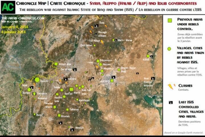
ISIL seems to have overstretched itself.  In Syria it has angered other Sunni rebel groups, including the Syrian-al Qaeda branch known as al Nusrah Front, to the point these groups are taking ISIL strongholds in western Syria.  However, in the eastern city of Raqqa ISIL is taking on the weaker rebels.  Cedric Labrousse of The Arab Chronicle has made some good maps of the rebel alliance versus ISIL Syrian subwar.

Areas in western Syria lost by ISIL. From Twitter.
Northwestern campaign against ISIL.  Note how the government forces have not been defeated. From Twitter. 

North-central campaign. From Twitter.
Raqqa counterattack by ISIL. From Twitter.
Meanwhile in Iraq ISIL is engaging in a Sunni civil war between those Sunnis in power who have nominal allegiance to Baghdad and some of the smaller tribes who did not suffer under al Qaeda in Iraq's strict rule of Anbar province in 2004-2008.

Some, but not all, of the ISIL-alligned fighters declared an independent state in Fallujah.  However, they did not define their borders.  This has not stop those on Wikipedia on making their own map showing all of Anbar and ISIL-held Syria as part of this state in the "Islamic State of Iraq and Syria" article. This shows the limits of Wikipedia's usefulness as pure conjecture takes over.

Bad Wikipedia map.

Tuesday, January 07, 2014

Christian-Muslim Cultural Warfare Continues to Center in Africa

Sub-Saharan Africa presents Islamism with its first roadblock since Spain. Malta, and Vienna in the Renaissance: Christianity that fights back and grows.  Even Christian cultural traits like Christmas celebrations are beginning to appeal to some Muslims thus causing an Islamist blowback.

Case in point the United Nations/United States-backed Federal Republic of Somalia, which has fought a slow, grinding, but so far successful war against the al Qaeda-linked al Shabaab, banned Christmas.  The fact that there are probably few to no Christians left in Somalia shows the fear the government has of religious-cultural "infection."

Meanwhile Islamist militias attacked and massacred Christians in Nigeria and Kenya during Christmas services.

Fighting back most actively against Islamism and Islam in Africa is Angola.  Led by non-practicing, former Catholics, Angola has closed down all mosques outside the capital in a move described as "banning Islam."  Even though Angola's leaders are not practicing Christians, they are pushing back in part with others as a pan-African push against Islam south of the Saharan Desert.

More violence in Africa is likely as faith becomes more fervent and even ideological on both sides.

Monday, January 06, 2014

Merry Julian Calendar Christmas!

Some Eastern Rite Christians (whether they be united with Rome or part of the somewhat loose Eastern Communion) use the Julian Calendar to mark Christmas.  That makes "December 25th" land on January 7th using the papal made Gregorian Calendar.  From Wikipedia:

Eastern Orthodox national churches, including those of Russia, Georgia, Ukraine, Macedonia, Montenegro, Serbia, and the Greek Patriarchate of Jerusalem mark feasts using the older Julian calendar. December 25 on the Julian calendar currently corresponds to January 7 on the internationally used Gregorian calendar. However, other Orthodox Christians, such as the churches of Bulgaria, Greece, Romania, Antioch, Alexandria, Albania, Finland, and the Orthodox Church in America, among others, began using the Revised Julian calendar in the early 20th century, which corresponds exactly to the Gregorian calendar
Either way: Merry Christmas! 

2013 Second-Quietest Tornado Year since 2000

The Examiner has a blog post discussing the latest confusion in climate change: the lack of extreme weather.  2012 had extreme temperatures but 2013's weather moderated and there was a decline in extreme events like tornadoes.  The key take-away:

The problem is that 2013 is proving to be among the years with the fewest number of tornados on record, according to data compiled by the National Oceanic and Atmospheric Administration's Storm Prediction Center in Norman, Okla.  
There have been 940 tornadoes in the U.S. between Jan. 1 and Dec. 23. Since 2000, the only year with fewer tornados was 2002, with 938. The year with the highest number of tornados was 2011, with 1,894. There were 1,119 in 2012.  
 The May 20 tornado that destroyed much of Moore, Okla., was an EF5, according to NOAA, with winds around 300 mph. That's the deadliest kind of tornado. The Moore EF5 was the only one of its strength level anywhere in the U.S. in 2013. 
There were six EF5s in 2011, seven in 1974 and five in 1953, the first year for which NOAA has such records.
This just goes further to prove that climatology is a very hard science to master.

Friday, January 03, 2014

Sunni versus Shia War Spurs Discussion of Changing the Direction of Muslim Prayers

Originally Muslims prayed towards Jerusalem.  This was done because Muhammad encouraged his followers to practice the Jewish and Christian beliefs of bowing towards holiness and the Temple.  However, the direction of prayer changed to Mecca as Muhammad was engaged by the Jewish refusal to convert en masse.

Since then there have been no serious discussion of changing the direction of prayer as the hajj to Mecca and prayer to Mecca hybrid together to make the city the holiest in all Islam.  That is until the Syrian Civil War heightened tensions between Sunni and Shia Muslims.

Iraqi Prime Minister (and practicing Shia) Nori al-Maliki has suggested the city of Karbala, Iraq be the new qibla (direction of prayer).  The Iraqi city is the home to the tomb of the Shia Imam Hussein.  Hussein's passion and martyrdom at the hands of Sunnis is a defining feature of Shia Islam.

Needless to say Sunni scholars are very upset at the very suggestion.  It is clear this is a dig at the Wahabi Sunni Saudi Arabia which currently controls the city of Mecca.

Personally I doubt this suggestion will gain any traction but it is clear that the Sunni-Shia cultural war will continue to get worse as fighting continues in the Levant.

Thursday, January 02, 2014

American Literature: Geography Used Instead of Heroes

The Acton Institute has a good blog post on how American Literature uses different regions instead of heroes to convey civic virtues.  The blog points out how this is more Roman Republican than later European literature which emphasized martial and saintly elite virtues symbolized in specific hero characters.

Key takeaways are
Prior to the modern age most literary heroes exemplified the martial virtues of the warrior (courage, honor, duty) or the theological virtues of the saints (kindness, generosity, faithfulness). They were the virtues of the elite, whether militarily, politically, or spiritually. But in the post-Civil War era, America needed to reconnect with the virtues of the citizen.
and
The ideal virtues of the Via Americana—qualities needed to conquer and civilize regional peoples under one American republic—are remarkably similar. But whereas in Rome these virtues were embodied in mytho-theological constructs (e.g., Veritas, the goddess of truth), in America we associate them with the geographic regions (e.g., the frugality of the New Englanders). 
and
Americans can associate themselves with virtues of regions in which they do not live because they share a common connection of Americanness.
The blog posts ends with a powerful question:
[D]o we need strong associative ties and allegiances to larger communal groupings (either regional or federal) in order to live virtuously in our own local communities? Can Americans be good localists without first identifying with the disseminated virtues of Americana?