It was a good day. The local group that volunteered met up a little bit after 9:00 am and drove together for the 45 minute trip to the state level geography bee. In the van we discussed various personal and professional developments in our lives. The conversations remained in a positive, humorous light.
We arrived at 10:00 am to the most beautiful non-college campus I have ever been to in my life. Green grass, several monuments, two museums, one library, a chapel, and a visitor center occupied the open grounds of the presidential library's campus. The Geography Alliance was very grateful because we were allowed access to the facilities for no cost.
For two hours we prepared for the competition. Going over the rules, looking over the questions to make sure we could pronounce all the unfamiliar words, and creating the score boards for each group. Lunch was provided and Catholicgauze had his Lenten cheesy breadsticks.
At noon we helped with the sign in process and talked with the contestants and their parents to put them in a less-intense state. Several speakers came to discuss the bee and remind everyone they were the top 100 geography bee students in the state and therefore they were all winners.
After the speeches it was time to break up into groups for the individual rounds. The group I was in was "Red Group." The questions ranged from two-choice softballs to one's that can only be equated to being repeatedly mauled by an extremely angry bear. After eight rounds we had one student get seven right, several get six right, and most kids getting five or four right. One of the fellow judges repeatedly commented to the other judges and me that this was "the result of No Child Left Behind," over and over and over again. It went well beyond any reasonible political point and deep into just be annoying. She was not happy with the group result.
A group of judges got together to pick the ten best students overall. Much to the surprise of the "No Child Left Behind" judge, several kids earned perfect scores and a few more earned sevens. All of the top ten either answered eight or seven questions right. No more mention of politics or educational policy were uttered. In the meantime, I broke off to join the other judges and helped distribute T-shirts, cookies, and punch to the contestants and their parents.
It was time for the final around at 3:30 pm. The motley crew was pretty much an even distribution of public schooled, Catholic schooled, and home schooled children. Two of the ten were students of Indian descent (the one's from Asia). The double elimination round went quickly. After a back-and-forth face-off, a public schooled ethnic Indian student won third. There were then two left: a Catholic school girl and the second ethnic Indian student. After three questions it was clear who the winner was. It was the same as last year- the same ethnic Indian student now in the seventh grade.
After the championship round I discussed the results with another judge who happens to also be an ethnic Indian. He told me how that the "creme of the crop" of Indians are the ones who are immigrating to America to improve their fortunes even further. Education is deeply stressed in their children. The winner and his dad reviewed almost daily for a year on geography. I in turn told the other judge about how private school have the mostly-accurate stereotype of being more academically challenging than public schools.
I received a packet on "My Wonderful World" and a T-shirt for helping out. I also had time to hit up the presidential library's gift shop to purchase a coffee mug, post card, and a seventy-five cent air plane glider (hey, cheap fun cannot be beat!)
On the way back the clouds began to darken as a thunderstorm rolled in. When I returned to my residence it started to rain. Soon a lovely spring thunderstorm began to commence.
So hear I am. It is now time to retire after a swell day of geography.
Saturday, March 31, 2007
Friday, March 30, 2007
Catholicgauze at the Geography Bee
Today Catholicgauze will have the honor of being a judge at the state level Geography Bee. This allows Catholicgauze to complete the circle of his life. In fifth, six, and eighth grade I represented my school at the state level.
For those who want to win the Geography Bee or just try their hand at similar questions I have recommendations:
Good luck to all the contestants!
For those who want to win the Geography Bee or just try their hand at similar questions I have recommendations:
- The official Geography Bee website offers an online quiz, the GeoBee Challenge, updated daily.
- GeoBeeCentral offers a message board populated by Geography Bee contestants and the Infinitia
- Geography@About.com has numerous educational resources available for free.
Good luck to all the contestants!
Thursday, March 29, 2007
Catholicgauze's Short Guide of Modern Geographic Thought
Here is Catholicgauze's Short Guide of Modern Geographic Thought (included are Catholicgauze's notable biases and dry humor)
Environmental Determinism
In the latter half of the nineteenth century Darwinism was all the rage. An increase in the interest of biology combined with old geographic ideas of the Greeks. German-trained geographers like Ellen Churchill Semple and others began to study groups of people and cultures through the framework of the environmental conditions. This became known as environmental determinism.
In short, these geographers believed people, cultures, civilizations, et al. could only develop as far as the environment would let them. Examples would be island people are isolationist because they live on an island or no advance culture could develop near the equator because it is too hot and when it is hot people do not work as much.
Environmental Determinism quickly got involved with Social Darwinism and racist ideals. It became a tool for those who supported imperialism ; the justification was that the natives were environmentally-capped and needed those from a better climate to care for them as best as possible.
Berkeley School Cultural Geography and Regional Geography
Around the 1920s there was a fundamental shift against environmental determinism. Two theories of thought more or less joined together and became the leading forces in geography.
The Berkeley School of Cultural Geography was based on the works of German geographers who believed that Culture (with a capital "C") was the highest unifying force of a group of people. Culture was everything from the arts, to beliefs, to customs, and more. Cultural geographers believed a person and people were capable of doing anything from making a desert bloom to adopting a new style of government; the only thing that imposed limitations on what was possible was the person or group's Culture.
Regional Geography was the lead in education at the time. Regional Geography what people think most often when they hear the word "geography." The study of countries and regions of the world is regional geography's domain.
However, over time regional geography was narrowed down in schools to become memorization of capitals and the three major export products. It was this that led to what Catholicgauze refers to as "The Really Bad Times."
Quantitative Geography (Or "Sadistics")
The end of World War II was a good time for geography. Regional Geography with a cultural emphasis helped win the war. Geographers were highly sought after by the government, universities, the private sector, and the opposite sex. It was an era of money, fast cars, and cute bunnies who sang to geographers as they left for work. In reality it was a time of crisis. Was geography a science or an art or something else?
Quantitative geographers promised to make geography a respected science. They proposed geography be done with numbers as well as maps. Means, correlation, t-values, and much more became known to geographers as they took statistics classes to understand what was going on in a spatial and numeric world.
The number crunchers had geography by the neck. To be considered a geographer one had to prove their data with numbers or be exiled. It looked like the establishment was victorious. Black suits with ties for everyone. Cold, square numbers held the throne of geography. However, the 1960s were coming...
Marxist Geography
David Harvey was one of the leaders of the quantitative junta which controlled geography. But in the late 1960s he discovered Karl Marx. Harvey rejected the quantitative revolution and embraced Marxist Geography. He saw geography as a tool to make the world "better" by imposing a Marxist viewpoint and goal on his studies. Everything became seen as a struggle between the has and has nots. The counter culture of the 1960s and 1970s help fuel the rise of Marxist Geography in departments in America and England.
The journal Antipode became a sort of Bible to Marxist and other "critical geographies."
Sedevacantism Geography
At the same time Marxist Geography and its critical relatives were taking on the machine there were many other geographic ideas. Behavioral Geography sought to study human behavior by combining elements of psychology and statistics. Humanistic Geography sought to understand "the emotions" of geography and rejected statistics completely. Meanwhile regional geography laid abandon in academia. The Berkeley School of Cultural Geography dwindled in numbers and the term "cultural geography" became the domain of the critical geographers.
Sedevacantism can sum up geography today. There is no one leading idea which is guiding everything else. While the big tent is nice for those who were on the outs with the establishment, geography is certainly suffering. Recently the geography department split at the University of Nebraska-Lincoln over the long debate of human geography versus physical geography. In other universities geography is frequently grouped with geology, anthropology, or even political science. This gives geography the label of "whatever is left science."
The Future for Geography
What will become of geography? The future right now points to more technology like remote sensing and especially GIS. But the geography has been known to switch directions quickly before. Maybe the globalized world at war will led to the rise of regional geography with elements of cultural studies. Maybe the potential of climate change will cause physical/environmental geography to become more popular. What is known; however, is that multidisciplinary studies are becoming more frequent in academia. The big struggle hear is for geography to remain unique and not be absorbed into things like "environmental studies" or "international studies."
Wednesday, March 28, 2007
Site Map of the Iranian Kidnapping of British Armed Forces

The BBC has a map detailing the opening events of the kidnapping according to the British government.
In related news the Iranian government has announced it will release sailor Faye Turney. Turney has been recieved media attention because she is the only female hostage and she is also a mother of a baby.
The price of oil has become a futures market for investiors speculation about a war with Iran. The more the price goes up, the greater the fear. Fill your car today or pay even higher tomorrow, for the time being.
Balkan Aspirations and Outcomes
 From Strange Maps
From Wikipedia
Serbia also went through a historical roller coaster. After starting World War I Serbia managed to gain many new lands by becoming the lead state in the union known as Yugoslavia. However, the state of artificial and only lasted because of the iron hand of Josip Broz Tito. After his death there was a short period of peace followed by a series of civil wars lasting until 1999. Today Serbia is a shell of its former self losing long time partner Montenegro and having its southern province of Kosovo being governed by the United Nations with Kosovo's final fate being unknown.
Romania has had a tough history but has come out more of a winner then the previous two. Transylvania was once part of Hungary but given to Romania because of Hungary's pro-Nazi government during World War II (Update: Romania receieved Transylvania in 1919 but Hungary reoccupied it in 1940. While Romania then adopted a pro-Axis agenda, in 1944 a coup changed Romania into the Allied camp) While the region has many Romanians who welcomed their homeland's reign many ethnic Hungarians still feel oppressed. Such is the condition of nations not in their own state. The country of Moldova originally hinted that it wanted to join Romania after Moldava's independence from the Soviet Union. However, the region of Transnistria has derailed this with an armed attempt to rejoin Russia. Plus, Moldova is too poor to be supported by growing but still cash-strapped Romania.
The last country on the map, Bulgaria, gained access to the Aegean Sea briefly but lost it to Greece during the Balkans Wars. Besides that Bulgaria has manged to have stable borders. A triumph considering the recent history of Europe.
The Balkans have been active the last 100 years just like the rest of Europe. So below is a parting video which I have featured before. It shows European boundary changes from the start of World War I until the mid-1990s.
Tuesday, March 27, 2007
Qatar's Catholic Church and What it Means
The State of Qatar is currently having its first purpose-built Catholic Church being constructed. The church will be under the Vicariate Apostolic of Arabia.
The native, citizenry body of Qatar are all Muslims and conversion to another faith is illegal. However, like other Arabian countries, much of the construction, hospitality, and tourism industry work is done by guest workers from countries like the Philippines, India, Eastern Europe, and Indonesia/East Timor. (Treatment of guest workers ranges from standard to nearly slaves) Some of these workers are Catholic and the guest worker program has boosted the Catholic population in Arabia to a stunning 1,300,500. Previously they had to worship in secret or in a limited public capacity.
With the establishment of the church Qatar takes another leap forward into the globalized world. Qatar allows women to vote and its increasing liberalized personal/religious laws are beginning to catch up with the likes of Bahrain and the United Arab Emirates.
There is an antipode to the liberal tri-Arab axis: Saudi Arabia. Under the strict Sharia guidance of the Committee for the Propagation of Virtue and the Prevention of Vice, religious freedom in the Kingdom is not permitted. Catholics and other non-Sunni groups are forced to worship in the shadows. Churches, temples, synagogues are not permitted. Conversion is punishable by death. Enterance of a non-Muslim into the cities of Mecca and Medina is also punishable by death. Prince Turki bin Faisal al-Saud invitation to the Kingdom is not entirely welcoming.
Saudi Arabia is under a Wahhabi religious regime which is revolutionary expansionist. The Wahhabi's are currently focusing their efforts with spreading their creed in Central Asia, Europe, and the more radicals are supporting the fight against Iraq and Afghanistan. These diversions have helped to allow liberal forces to open up the tri-axis to the rest of the world.
The axis and Saudi Arabia have a bit of give and take going on right now. Qatar, the more moderate of the liberal three, is tempered by the fact it is a weekend getaway place for many Saudis. But the liberal ways of the axis are seeping into the Kingdom too. While it was extremely limited, local elections have been held in which a wide array of candidates were elected to office. And some universities are allowing women to attend. Finally, women no longer need the permission of their husbands to leave the Kingdom on vacation- any close male relative will do.
One external event will impact the liberalization or Wahhabization of the Arabian peninsula: the War on Terrorism. If the Coalition can finish the job they started and build up a stable, democratic Iraq then the conservative countries will be pressed by liberal countries on two fronts. If al Qaeda in Iraq is victorious in creating a chaos state then the momentum will be with the Wahabbis and Islamic fascists will bring the fight against their liberal home countries. If the Shia militias backed by Iran can make Iraq a Shia satellite state then the future of liberalization is up in the air. Iran is liberal in some respects while being oppressive in others.
Time will tell.
Monday, March 26, 2007
Viewing and Thinking about the World Anew
I love maps. Maps allow me to envision the world, its phenomenon, and the interactions of people. They allow people to communicate with others in a form which is a neigh-universal language. Without maps the study and use of geography is pointless.
Maps can lose their luster however when we think of them as mere objects. I discovered that just a while back. I was used to seeing world maps centered on the intersection of the prime meridian and equator. This common style world map splits the Pacific Ocean in two. Then I found a map which was centered over the Pacific Ocean. I realized then the remoteness of the Pacific Islands, the wonders of international trade along the Pacific Rim, and the vastness of the seas. By just changing the focus point I saw the world anew.
I began to tinker with the map and globe. The best view (my recommendation at least) to start your mind thinking again about the world is below:

We often hear of how approximately 70% of the earth's surface is water. But this view which centers on the Pacific upside-down allows one to truly comprehend that fact.
Catholicgauze recommends all to seek out new maps and view globes from exotic angels. Do not let maps and globes become static drawings but instead let them remain dynamic learning tools. Explore the representations of the world in a whole new light today!
Sunday, March 25, 2007
From Google Earth to Finish Map: How to change KML to SHP files to a finished map for free
Note: This is one way Catholicgauze has discovered to made "professional" looking maps. If you have your own way feel free to comment and share!
As part of my efforts to eventually get my writings on the Oregon Trail published I have been creating maps. However, as a poor person most cartographic programs are beyond my reached. However, by scouring the internet I have found a way to make maps for free. All one needs is a little time and several easy to use freeware programs.
The programs I used for the project are
Google Earth
KML2Shp
Forestry GIS
Paint.net (or any other drawing program)
So here is my train of thought as I worked. I needed to make a map showing the Oregon Trail going through modern-day states. I wanted to do everything myself and on some stuff I had no choice (is was no Oregon Trail SHP file before I made it- to my knowledge).
So what I did first was to create the states. With Google Earth I proceeded to use the "Add polygon" tool to draw out the various states. After that I drew the Oregon Trail, according to paper maps I had. To do this I used the "Add Path" tool. Finally I made polygons over popular sites along the trail like Fort Laramie.


When I was pleased with the creation I saved all the state and sites polygons and the Oregon Trail path as KML files.
Next I loaded all the KML files one by one in KML2Shp and converted them into the standard GIS SHP file. It was a fairly straight forward process. However, some installations of the program fail to load all the necessary BPL files. If this happens download the needed files here.

So now I had all are manually created files in SHP format. I used Forestry GIS (fGIS) to load each file as a layer. I then created a buffer to enlarge the trail to make it more visible. I followed the same step make the locations viewable. As a last step I labeled the locations.

So now I had the map almost complete. I did final touch-ups on Paint.net. A simple "Print Screen", then paste, then with a crop I had the map on a white backdrop. I adjusted the tilt sightly and added a title on the bottom using the text tools. With this I was done and my "professional" (big time quotations needed) was complete.
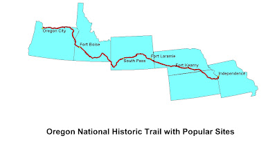
So that is Catholicgauze's long way route on how to make maps. I would like to thank Free GeoTools for pointing out KSL2SHP.
Saturday, March 24, 2007
Oldest chunk of Earth found
A piece of rock which was once part of the ocean's crust has been found in Greenland. The rock is estimated at 3.8 billion years old.
The upsurge piece of crust is evidence that active plate tectonics is older than previously thought. It was previously believed the continents only cooled enough around 2.5 billion years ago for plate tectonics to even occur.
Stories like this makes me appreciate and wonder just all what has happened on the earth.
Friday, March 23, 2007
Iran kidnaps British armed forces

15 British sailors and marines have been kidnapped by Iranian Revolutionary Guard. The Brits were doing a standard boarding and check operation on a freighter vessel in Iraqi waters when they were surrounded by fast attack boats belonging to Iran. Without a shot the Iranians removed the British sailors and took them into Iranian waters. The current location of the navy personal is unknown.
The sailors were seized near the Shatt al-Arab which has long been in dispute by Iran and Iraq but internationally recognized as Iraqi.
There are several ways to read this incident on a immediate basis. It could have been a setup where the Iranians had been hoping a ship would boarded and sprung the trap when the Brits boarded a vessel. Or the freighter could have been carrying supplies for Shia insurgents. When the vessel was being boarded the Iranians may have decided the contents were worth protecting and launched their ambush on the sailors.
This is the second time British sailors have been kidnapped by Iran. In 2004, eight British sailors were captured then released. It has been rumored that Iranian President Ahmadinejad wanted to kidnap Coalition troops ever since Brigadier General Ali Reza Asgari defected to the west
Mexican National Atlas
The Institute of Geography at the National Autonomous University of Mexico offers the fascinating Mexican National Atlas in Spanish.
Maps range from the geology of the Mexican ocean waters to biological regions to international diplomacy to migration of people throughout the country.
While all the maps information are in Spanish, maps can be read by anyone. Enjoy today! (Hat tip: Free GeoTools via hablandodesigs)
Maps range from the geology of the Mexican ocean waters to biological regions to international diplomacy to migration of people throughout the country.
While all the maps information are in Spanish, maps can be read by anyone. Enjoy today! (Hat tip: Free GeoTools via hablandodesigs)
Thursday, March 22, 2007
Europe on a Suicide Path
Earlier I wrote how Europe must curb discrimination. But towards the end I warned Europeans must preserve their own cultural legacy while integrating in new arrivals.
Case in point, a German judge ruled wife abuse is legal in Germany (Hat tip: LGF). The ruling was not based on German Basic Law (the constitution) which has rules about human dignity. Instead the judge ruled the Koran allowed wife abuse and the Koran applied to Germans.
Roman law lasted well after the fall of Rome and became the foundation for most of Continental Europe's legal systems. Greco-Roman culture became the basis of Western civilization. The color of "Europeans" has been constantly changing since the dawn of time. All these groups eventually exchanged ideas and integrated. However, now Europeans are encountered a group which seeks to replace everything Europe stands for.
Can the torchbearers of Western civilization withstand a direct assault on their beliefs? Or will they merely just roll over?
Hungarians hate Piresans, Europeans hate everybody
A recent poll showed Hungarians want no more Piresans to enter the country. One problem exists with the poll. There is no country of Piresa and therefore no Piresans.
The poll can be taken as a joke but there is deeper meaning behind it. No matter what the group, Europe has a problem with racism and xenophobia. Even though the United States has had its own problems of racial relations, Europe has continuing racial difficulties which far surpass America's.
The original whipping boys of Europe were the Roma and Jews. Racial tensions against these groups has taken two different routes. Hatred towards the Roma is lessoning slowly in Eastern Europe where the Roma have lived for centuries. In Western Europe there is an increasing population of Roma who do day jobs to survive. Some have resorted to begging, crime, and even prostitution. These Roma operate in tourist areas, visible to both foreigner and national, and have given the Roma a reinforced negative stereotype in West European news media.
Jews on the other hand are in a tighter spot. Fascists on the Right have public displays of anti-semitism at rallies and soccer games. Though the main source of anti-semitism in Europe comes from the political Left and Islamists. The issue of Israel/Palestine has been taken to the extreme. Centuries old Jewish cemeteries, synagogues, and modern day businesses are frequently vandalized with Nazi or even Arab symbols. Memorializing the Holocaust in some English cities has become difficult as local Islamist leaders campaign against it. While there is no threat of a second Holocaust, it is frequently said anti-semitism is reaching pre-World War II levels in Europe.
Muslims have also become victims of xenophobia. Many parties on the political Right have become harsh towards Muslim immigrants. LePen's National Front and others have gained some power by tapping into Europeans tired of supporting the welfare of a growing population which has a radically different culture than there own. The fact there have been acts of terrorism committed by immigrant Muslims and non-committal of community leaders has not help curb Islamophobia. Some Muslims have responded to this by setting up their own microstates in European cities. These microstates are now enclaves of Islamism in the Western world. Here, European is dead and "Eurarabia" lives.
Discrimination is a serious which Europe must deal with for several reasons. On the immediate level increasing membership in the European Union is allowing for many new and old minority groups to freely move around the continent. Old Europe is becoming increasingly multicultural whether they want to or not. To not deal with issues like discrimination only invites disaster. More distantly, but still with urgency, is demographics. Traditional Europeans are dying out while immigrants (Muslims mostly) and other ethnic groups continue to grow. If Europeans want their cultural legacy of individual freedoms and progressive rights to survive; then they need to stop ostracizing groups and encourage enculturalization. Some Europeans have gone to the opposite extreme of changing their own ways to that of the immigrants. While some cultural exchange is healthy; to bow down to some demands like Sharia abandons what Europe stands for.
Discrimination is a problem all over the world. Europe is especially impacted and must change or face demographic and cultural obliteration.
Wednesday, March 21, 2007
Economic Freedom Worldwide

Click to Enlarge. From The Heritage Foundation
The Heritage Foundation has released their annual Index of Economic Freedom.
The list rates various freedoms including business freedom, trade freedom, monetary freedom, freedom from government, fiscal freedom, property rights, investment freedom, financial freedom, freedom from corruption, and labor freedom.
The top ten countries are (Full list):
- Hong Kong
- Singapore
- Australia
- United States
- New Zealand
- United Kingdom
- Ireland
- Luxembourg
- Switzerland
- Canada
The top seven all have been strongly culturally influenced by England and the English ideals of personal and economic freedoms. Depending on one's definition the top seven (and Canada) can all be considered part of the Anglosphere.
A secondary break down has Hong Kong and Singapore as Asian tigers. Japan and South Korea are somewhat distant from the top ten but no lower than number 36.
Switzerland has always been classical market liberals along with being neutral. It has recently rejected European Union demands to be less economically free. Luxembourg has liberal banking and investment laws and the open trade that comes with being a member of the European Union.
The bottom fifteen countries include Venezuela, Iran, Zimbabwe, Libya, Cuba, and North Korea. The bottom part of the list coincides with Thomas Barnett's Gap. These countries are either African, Islamic, Communist/Thug Communist, or a combination of the variables.
The states which repress freedoms like economics and personal ones ("the freer the market the freer the people") are the more troublesome countries in the world. These governments suppress their own people and other countries which try to improve themselves. Sometimes these oppressive groups will unite to combat the economically free, globalized countries.
Tuesday, March 20, 2007
Out of the Box Ways to Combat Global Warming
Fox News has an article about ways some scientists are thinking about to combat global warming. These ways go beyond reducing carbon-dioxide and are much more original. Ideas range from artificial "trees" which would scrub the air of greenhouse gases to dumping iron dust into the ocean in order to cause a boom in plankton population. The idea which scares Catholicgauze is the man-made volcano. No way that idea can go bad!
Monday, March 19, 2007
Extreme European Weather Map

My fellow Europeans, Meteoalarm has just received credible reports that severe wind will strike Norway. The threat level is now red.
Meteoalarm is a online, interactive map which locates and describes severe weather in many European countries and Cyprus. The continent view shows the various countries weather state (something similar to the American Homeland Security Advisory System) and the view can be zoomed into a country level. The country level then displays the various types of weather activity. By clicking on the extreme weather event one can attain a short description of what is going on.
The neat thing about Meteoalarm is that it is a online geography tool not based on Google Maps, Virtual Earth, or any other related program. I wonder if developers like to use pre-made API or if building from scratch allows them much more independence in design.
Sunday, March 18, 2007
The Hamas-Fatah Palestine
Members of Fatah and Hamas have agreed on an unity government in hopes of ending the bloodshed that both their respective militias have released upon the Palestinian people. The new government says it is moderate and recognition of Israel is implicit. However, the United States is "disturbed" by the government's platform due to, among other things, the continued support of armed violence against Israel.
Norway announced it will resume relations with the Palestinian Authority. This means Norway will restart aid shipments of supplies and money to the Hamas-led unity government. The various governments of the Western world originally cut off aid after Hamas' electoral victory in early 2006. Iran has been able to offer some monetary and military support to the Hamas government in the meantime. This relationship has led Hamas' Palestine to be in the very rare minority of Sunni governments who support Iran and Hezbollah.
Norway seems to be Nixon going to China. Several other EU countries are planning on resuming support to the Palestinian Authority and Arab states are putting pressure on America to recognize the new government. The United States blessing is the prize for Hamas. If it can get American aid than no one can doubt Hamas' legitimacy and it will be able to bank roll its expanding power base.
The real wild card in this situation is violence. Fatah and Hamas have always had an on-again, off-again low level civil war in the Gaza Strip. If violence is ended or severely curbed than more recognition and power will come to the Palestinian Authority. If Fatah or Hamas resumes the conflict though the government will collapse and aid shipments will stop. It is hard to say what will happen.
Saturday, March 17, 2007
Iraq Upate 3/17
After a successful start with over 80% drop in violence, anti-government forces are fighting back.
There are two big pieces of news today. First a chemical weapon, a chlorine dirty bomb, was detonated in Sunni Ramadi. It appears to be the work of al Qaeda which is currently fighting against both the government and local tribes. The use of chemical weapons has been outlawed by various countries under the Geneva Protocol. The Islamic State of Iraq, al-Qaeda's political organ in Iraq, refuses to recognize any treaty not based under Islamic law.
Things in Sadr City are also heating up. Moqtada al-Sadr earlier fled his stronghold to Iran. This left a power vacuum which the United States has exploited and has therefore been allowed to enter Sadr City peacefully. The mayor of Sadr City who allowed Americans to enter the ciy has recently come under an assassination attempt. Now one of Sadr's clerics is calling for the Americans to leave or be kicked out of Sadr City. With Sadr's power lagging and his lieutenants taking over more operations it is important for Sadr to show he has sway still in the city. The only way for him to appear powerful is by following his old play book of causing serious trouble for the Coalition. Look for more open calls for violence from him in the near future.
Virtually Visiting Grande Terre of the Kerguelen Islands

As I was wandering around Google Earth the above caught my interest. On Grande Terre of the Kerguelen Islands there is a frozen river that only melts near the shore. It was such a stunning thing to behold I decided to see more of Grande Terre online and share it with you.
The islands of Kerguelen are formed by dormant volcanoes. The weather is harshly cold with high winds and rough seas for most of the year. The closest land mass is Antarctica at about 1,200 miles away while Africa and Australia are almost double the distance. The landscape is heavily glaciated with mountains all over the place. The swampy eastern area is covered by snow during the winter.
There is a richness of life on the land, though. Penguins (lots of them), sea lions, and other types of sea birds all make homes under the Southern Lights. Ferrel cats from ships have thrived on the island. Scientists live year round on the island and minor rockets are periodically launched from the base.
To see the greatness of Grande Terre there are several places to go. There is an interactive map which pin points where pictures were taken here. There are pictures on Google Earth which can also be viewed via Panoramio. There are more galleries also online. Finally, Discover France has some introductionary information.
Friday, March 16, 2007
Juicy Geography: Help with Teaching Geography
With Catholicgauze and the other members of the quadumvirate (let us all hope for a happier ending than the one the two triumvirates had) being educational I decided to look around for other resources for teachers. Well apparently everyone but I knows about Juicy Geography but I will still point it out for others who are interested.
Juicy Geography is partially-user driven website in which teachers can share ideas on how to teach geography in class. Lesson plans and other ideas using Google Earth, GIS, or just plain paper are available for free. Field work examples, geography games, hands-on projects are other things one can check out. If you have your own ideas you can even share them with the rest.
Is the internet not a grand place for geography to spread and grow?
Thursday, March 15, 2007
Catholicgauze: Now Educational!
Geographic Travels with Catholicgauze! is one of four blogs recommended for Social Studies teachers and students by McDougal Littell. Congratulations to my fellow recommend blogs of The Map Room, Geography@About.com, and Geography Matters.
Wednesday, March 14, 2007
HEALTHmap: Mapping Diseases Around the World
HEALTHmap is a neat tool for following news about diseases all over the world.
The mash-up gathers developments and news from the World Health Organization, Google News, the European Centre for Disease Prevention and Control, and the International Society for Infectious Diseases. The variety of news sources allows for a fairly equal distribution of first, second, and third world events dealing with disease and health issues.
Various layers of disease news can be toggled on or off. Countries or regions can be zoomed in on, also.
For those who are interested in medical geography or just like mash-ups this is one worth checking out.
Tuesday, March 13, 2007
Tide Turns Against Extreme Global Warming Hysteria?
Now with working video
Global Warming has been in the news alot lately. Al Gore's opus has won two Oscars, given screen time at all of Scotland's secondary schools, and has raised public awareness about climate change. For a time it seemed that the Gore-version of global warming was set to dominate.
Things seem to be changing. First it was revealed that the Gores use thirty more times the power than the average family. His carbon-offsets which he used to justify his world travel are actually stock in a company he partially owns (which promises to invest them in carbon offshoots but still...). Now the New York Times has written article which attacks Gore's extremist view on global warming. This follows up an opinion from ABC by the former editor of the Journal of Biogeography which discusses extremism in global cooling/warming debates.
Climate change is an issue which should be discussed and dealt with (but remember, the IPCC says we cannot stop global warming). The problem is that some have overblown the threat too far and made it a religion, in the words of the Czech President. When people realize the flaws in Gore's argument they will feel betrayed. They will then doubt any claim on global warming or climate change. There are risks with climate change which must be weighed and considered for the good of globalized world and humanity in general. Crying wolf only hurts protecting the environment.
There are many good people on all sides of the climate change debate who want only what is best. However, some are using the threat of environmental disaster to create a "new world order," curb the power of sovereign states, or expand radical Islam. Those who oppose the dogma/political aims are shunned, accused of working for the oil companies, or in rare cases threatened by nut jobs.
Keep discussion on these issues alive. Climate change could be a minor inconvenience or it could be a great threat no matter what is causing it. To listen to the likes of Al Gore who do believe should not have equal time or even given credence to by the press would potentially lead to disaster. If the breaks of the world's economies need to be slammed we better know for sure that it is necessary before we hurt ourselves and those who rely on our aide.
Below is "The Great Global Warming Swindle" It is one side of the debate. Listen to all sides but remember to be logical and rational with everything you hear.
Monday, March 12, 2007
GIS Lounge: Your GIS one-stop shop
Caitlin Dempsey, a reader of GTWC! and former editor of GIS@About.com, has guided to GIS Lounge.
GIS Lounge is the second coming the old About.com site. Plenty of information is available including information about what GIS is, links to job listings, industry news, fun things to do with GIS, and much more. Check it out today!
GIS Lounge is the second coming the old About.com site. Plenty of information is available including information about what GIS is, links to job listings, industry news, fun things to do with GIS, and much more. Check it out today!
Sunday, March 11, 2007
Geography and Film: 300

300 is based on a graphic novel which in turn is based on the Battle of Thermopylae. I would rate the movie about 4.5 out of 5 praising it for its battle scenes and artistic style but wondering if all the nudity in the first part was necessary.
For those interested in the actual battle and how it compares to the movie Victor David Hanson has the knowledgeable information.
SPOILERS AHEAD
The geography of the film is fantastic in that it is both great and preternatural. Greece is depicted as a land of muscular men, strong and beautiful women, and picturesque lands. The Persian Empire on the other hand is a cosmopolitan mixture of everything that is morally wrong. War elephants and war rhinos are fierce beats, the Persian Immortals and other elite troops of Xerxes are physically corrupted humans. Not since the days of religious plays have the inner strengths and weaknesses been shown as physical qualities in such a dramatic way.
Another aspect in the film is politics. While the film makers deny political bias it is clear the beliefs of Frank Miller have played a role. Queen Gorgo makes the case for the war while the oracle priests (the United Nations) are swayed by bribes and Spartan politicans feel this is not their war (anti-Iraq War Democrats). "Freedom is not free," says the queen to the council. Elsewhere in the movie the Spartan king turns down offers of an "exchange of cultures" and personal honors which would be exchanged for surrender of rights and freedoms. At the end of the movie a soldier named Dilios tells the united Greek at army that this is war against "mysticism and tyranny." Sound familiar?
SPOILERS END
In case you need any more reason to see the film check out the trailer below. PREPARE FOR GLORY!
Saturday, March 10, 2007
Abu Omar al-Baghdadi Captured!
UPDATE: It is not Abu Omar al-Baghdadi but another "big fish"
Abu Omar al-Baghdadi has been captured. He was the head of the Islamic State of Iraq, the al Qaeda founded group which has been promised the loyalty of al Qaeda in Iraq by Abu Ayyub al-Masri. At least nominally, al-Baghdadi was the highest ranking al Qaeda member in Iraq. He first entered Iraq in 2002 to setup terrorist training camps before the Coalition invasion in March 2003.
This is the second leader al Qaeda in Iraq has lost.
This is great news. The surge, at least in the short run, is working. Al Sadr has fled to Iran and now his militias are fractured and allowing Coalition troops to enter Sadr City. Terrorist attacks are down by a whopping eighty percent! To win the Iraqi and American armies must continue to run down targets and allow them no safe havens like Fallujah and Sadr City once were.
The news also has a sign of change. Unconfirmed reports that have reached Catholicgauze say the raid which captured al-Baghdadi was done by the Iraqi Army and not American forces. Go get them guys!
Friday, March 09, 2007
The Future for GIS
This blog post could have started with "It was the best of times, it was the worst of times for Geography," but that is too close to plagiarism for comfort.
Geographic Information System is probably the most useful tool for geographers to come onto the scene since the computer. GIS allows geographers to manipulate data, define searches, and study spatial relationships with relative ease. It is such a powerful and useful tool that many disciplines ranging from wildlife management to planning to agriculture to architecture all have found uses for it. Examine non-geography major students taking upper level geography classes and all but a few of them will be enrolled in GIS classes.
GIS has long been at the center of controversy; however. When it first came out to the general public some in academia decried it as a tool of the establishment. Saying that it was evil because it was first developed by the "military-industrial complex" or that it did not take into account those who would be disenfranchised. A tool, much like Microsoft Word, was declared bad. To this day some Marxist et al. geographers have attempted to reform/corrupt GIS. One of the major geographical journals just published an article on a feminist critique of GIS and how it should be more subjective to factor in feelings. (Do not ask Catholicgauze how this is to be done; somethings are beyond my comprehension)
GIS has been immune from attacks like this. Many of those who use GIS are not in academia but in the career world and have no time for post-structuralist thought. This independence can turn into isolation and secession.
There are those who worship GIS as a thing in and of itself. Some schools like Harvard only teach how to do GIS while calling it geography. Others have started Geographic Information Science programs which dedicate themselves solely of the study of GIS.
With GISc focusing only on GIS, the whole reason GIS exists, to study spatial phenomenon, is kicked out the door. When GIS is the pinacle of everything geography loses. What has happened is that many GIS users have no knowledge of geography. With a few clicks of a button a GIS jockey can describe data's distribution but cannot explain why things are the way they are. A monkey can do that work.
To continue down this road would be a disaster for both geography and GIS. If GIS goes its own route under a banner of GISc while GIS operating tools become easier to operate, a "tech schoolization" of the tool will occur. It will become something to outsource to the lowest bidder and require no thought. GIS users could become the next administrative assistants. Once touch typing abilities were highly valued, no longer. Intelligent people need not apply in this future. A split would also hurt geography. Many departments receive a large share of their funding due to work they do with GIS. Geographers need GIS to survive in this economic system. GIS needs geography to give it a special meaning no other subject can.
Thursday, March 08, 2007
Geography of Denial
 Countries which outlaw Holocaust Denial
So instead of complaining some more I decided to do what I do best: geography. I have created a map where Holocaust denial is illegal (while I do not advocate criminalizing Holocaust denial I shed no tear). Wikipeida has a good chart on the punishment for denial in the various countries.
Only one two governments openly state the Holocaust never happened. Iran and the Hamas government of Palestine have at various times referenced the "so-called Holocaust." Besides governments many unofficial and semi-official branches of Arab governments continue to deny the Holocaust. These denials are aimed at trying to deligitimize Israel.
A weird love/hate relationship has devloped between Arabs and Nazism. On the one hand many Arabs will state Nazis were not that bad and/or the Jews had it coming. Mein Kampf continues to be a best seller in many Arab countries. However, when protesting Israel the same Arabs will say Israel is acting like the Nazis.
Elsewhere governments continue denials on other genocides. Turkey denies the extent of the Armenian, Pontus, and Assyrian genocides. Japan also refuses to recognize atrocities committed in occupy China during World War II. These denials are also due to modern-day political issues.
Those who do not learn from the past are doomed to repeat it...
Wednesday, March 07, 2007
Atlas of Subways
Amadeus Global Travel features a large collection of maps depicting subway systems around the world. Maps can be viewed online or downloaded into a PDF or Word document.
Catholicgauze hates the Chicago system with a passion after my infamous "Bush League" experience in Chicago. Note how on the Blue Line there are several stops with the same name on opposite ends of the city. Dang you, Chicago; dang you to heck! (Hat Tip: The Map Room)
Catholicgauze hates the Chicago system with a passion after my infamous "Bush League" experience in Chicago. Note how on the Blue Line there are several stops with the same name on opposite ends of the city. Dang you, Chicago; dang you to heck! (Hat Tip: The Map Room)
Tuesday, March 06, 2007
Countries Negative Influences on the World and Flawed Thinking
The BBC has announced the results of a poll which has Israel, Iran, and the United States as having the most negative influence on the world. "The world" consists of 1,000 people each in Argentina, Australia, Brazil, Britain, Canada, Chile, China, Egypt, France, Germany, Greece, Hungary, India, Indonesia, Italy, Kenya, Lebanon, Mexico, Nigeria, Philippines, Poland, Portugal, Russia, South Korea, Turkey, the United Arab Emirates, and the United States.
The poll (PDF of results on the US) shows the world having a 32% positive/49% negative opinion of the US. 68% of respondents said the US military in the Middle East causes more conflicts rather than being a stabilizing force. Other issues upsetting the world are the Iraq War, global warming, and treatment of Guantanamo prisoners.
Several countries are remarkably pro-American: Philippines, Kenya, and Nigeria. Hungary and Poland are moderate in their opinions of the United States.
What can be made of this. In short: the bulk of the world hates (yes, I know the usage and emotion of the word) while select regions favor America. But why?
Well, the select African countries, including Nigeria with a large Muslim population, receive direct aid from the United States and know what life would be like without America. $34 billion dollars a year are given by PRIVATE aid groups in the United States alone. Approximately 25% of all economic activity is done in the United States. Without open trade and interaction laws the countries which need development the most with dive deep into depression. Ever been to the Caribbean and wonder what would happen to these places without tourism dollars?
But why is the United States hated? More people think the US has a worse impact than North Korea, whose monstrosities can be documented by even blogosphere, and China which is in the process of economically colonizing Africa and supporting dictators who oppose liberalization with brute force and genocide. In part it is due to the Soviet's propaganda machine which instead of directly trying to influence events created a self-sustaining Marxist subculture which seeks to destroy the establishment (United States and allied institutions) in the West. This subculture continues to live today even after the fall of communism and the fact that Communism killed more people than the Nazis ever dreamed of. The current war against Islamic Fascism has also lead to anti-Americanism. The pro-Islamists have adopted old socialist critiques of Western culture and tied it to Islamism. To paraphrase Ibn Warraq "Why do they hate us? ...Because they are taught to hate us!"
Catholicgauze tends to be dismayed at poll results like this. Before the US was in the Persian Gulf there were several wars of Iraqi expansion from the Iran-Iraq War to the Gulf War. The only time the US did not intervene afterwards was during the massacring of the Shia after the Gulf War. The US military is also absent in North Africa which is hardly a stable place with Darfur. One can think the US has made mistakes but before one says the US has the most negative impact on the world just think for a second. Where was "the world" during Rwanda, the Balkans, Iraq, Darfur, North Korea, et al?
What are your thoughts, readers?
Monday, March 05, 2007
Playing Odds with Near Earth Objects
Near Earth Objects are asteroids, meteorites, and comets which cross Earth's orbit path and therefore pose a risk of impact. There are currently 4,187 known but almost everyone accepts there a more that have not been detected yet.
To put your worried minds to ease somewhat here is the Current Impact Risks chart. The one that currently has the best chance of hitting Earth is 2000 LG6 with the probability of 0.086% or 1 in 1,160 chance. That means there is a 99.914% chance the asteroid will miss the Earth. Have a nice day and enjoy the skies!
To put your worried minds to ease somewhat here is the Current Impact Risks chart. The one that currently has the best chance of hitting Earth is 2000 LG6 with the probability of 0.086% or 1 in 1,160 chance. That means there is a 99.914% chance the asteroid will miss the Earth. Have a nice day and enjoy the skies!
Sunday, March 04, 2007
Iraq War Maps
The Fourth Rail has two good Iraq War maps that are relevant as the surge begins to pick up steam.
The first one is an animated map of Iraq showing the three provinces where the Iraqi Army is in full control, provinces where the Iraqi Army is in the lead, and the remaining areas where the US or UK is in control.
The second map is a detailed one of Baghdad showing the ethnic makeup of each neighborhood and where different army units are operating.

Click above map to play

Saturday, March 03, 2007
Switzerland invades Liechtenstein
For too long Switzerland worked while Liechtenstein fiddled away time. As Liechtensteiners went along with their daily lives, little did they know that jealous and envious eyes watched and studied them. Then, like a thief in the night, over 100 Swiss soldiers snuck across the border and the rest is history.
Actually, Switzerland's troops accidentally crossed the border and quickly retreated after they noticed their mistake. Both countries are downplaying the incident and this story is being placed in the trivia of history pile.
The incident becomes more hilarious when one knows the history of Switzerland and
Liechtenstein. Switzerland has a serious military program but for centuries practiced neutrality. Switzerland is so neutral that it only recently joined the United Nations. Liechtenstein got rid of its military in 1868 because it cost too much and has relied on Switzerland to provide guidance in foreign affairs. With very libertarian banking laws Liechtenstein is Switzerland's Switzerland.
Friday, March 02, 2007
Representations of Indians and US Army along the Oregon Trail: Nebraska up to the Kearney Complex

The first 180 or so miles in Nebraska are uneventful. Wagon trains passed the Great Plains of Nebraska searching for an oasis in the wilderness. This stop would have full supplies and even mail for some of the emigrants. The stop was Fort Kearny, which today is in the lower-middle of Nebraska. It was a safe harbor in a sea of bad dreams.
To get to Fort Kearny the pioneers had to pass by a vast expanse of territory. After St. Marys they left the Potawatomi reservation and entered the unregulated lands of the Pawnee. Many wagon trains gave offerings for safe passage but there were reported incidents of murder and a raid or two. Tensions were high and the happy days of Kansas were behind as the realism of a 2,000 mile trek began to settle in the minds of emigrants.
Due to the Pawnee's semi-nomadic nature there were no common site for meetings and other forms of interaction. Partly because of this there are no makers or monuments relating to local Indians or anything else dealing with the Oregon Trail from Rock Creek Station to Fort Kearney. There are roadside markers at the site of Pony Express stations but the only times Indians are mentioned are when a band attacked or harassed a station.
The first stop, Rock Creek Station, is dedicated to life along the trail but does not deal with Indians or Army. However, the station began operations in the late 1850s and the Indian issue was for the most part moot in that region by then.
Flash forward many miles and one reaches the Kearney Complex of Fort Kearny and Great Platte River Road Archway Monument.
The fort was named after Stephen Kearny and opened 1848. The fort served as a center of operations for dragoons and calvary, a supply post for Oregon/California/Mormon migrants, and a trading post for Pawnee and even Sioux Indians. In 1864 there was heightened tensions leading to conflict in the area but the era of the classical Oregon Trail was over by then.
The fort today is beautiful. A gift store/information center is located in the museum while a few recreated buildings like a blacksmith shop and a wooden stockade occupy the grounds. The mueusm focuses mostly on the daily life of a solider and officer. The idealized hero on the threshold of a new frontier is replaced by the average man just trying to do a job. There is a section of the museum which focuses on the Pawnee scouts who aided the US Army against their mutual rival, the Sioux.
After Fort Kearny one visits Kearney, Nebraska's great monument to fiscal waste known as the Great Platte River Road Archway. For eight well-spent dollars one is taken on a multimedia tour of the Great Platte River "road." About 1/2 of all exhibits deal with the Oregon/California/Mormon trail while the other half deals with the Pony Express, transcontinental railroad, Lincoln Highway, and interstate system.
The Archway is a nice place for people who know little of what the trails were like. I was quite impressed by its presentation. There were some oddities however. Fort Kearny is the start of the museum and is seen as the last stop of civilization rather than an outpost. No hint is given of army patrols which sometimes aided the wagon trains. Also, Indians are given their fare mention but are separate from interactions with emigrants. Finally, all Indians are presented as the same in the sense they lost the West. However, groups like the Potawatomi never had the west and groups like the Pawnee came out much better than tribes like the Sioux.
Kearney is now behind us. Ahead is another long stretch of unmarked space until Ash Hollow.
Thursday, March 01, 2007
Blizzard
Well, I am now with family and learning to say goodbye. We are focusing on the good times we all had with dad. The community outpouring has been stunning. However, due to blizzard conditions we will be unable to attend my father's viewing. The funeral is tomorrow.
I just wish to thank everyone who has helped in this time of my life. To my friends back at school and to my blog readers. Thank you.
I just wish to thank everyone who has helped in this time of my life. To my friends back at school and to my blog readers. Thank you.
The Underground Seas
A huge new underground ocean has been discovered (hat tip: Very Spatial), but it is actually more of an aquifer than ocean. The ocean lies about 400 to 800 miles below the surface of eastern Asia. While it is located well into the mantle, the ocean does play a moderating effect on some of the seismic activity in the area.
While some think of underground seas when considering the moon's of Jupiter there are many on earth. It has been estimated that there are over 145 lakes underneath Antarctica's snows. America has The Lost Sea which is a 13 acre cave system completely filled with water.
The idea of an underground body of water is not new. Many ancient mythologies like Egyptians and Greeks had seas and rivers below the surface. Even the drugged out Samuel Coleridge dreamt of a sunless sea in his "Kubla Khan" poem. However, one must remember the "ocean" is really just wet rocks before one makes plan to buy a submarine.
Subscribe to:
Posts (Atom)