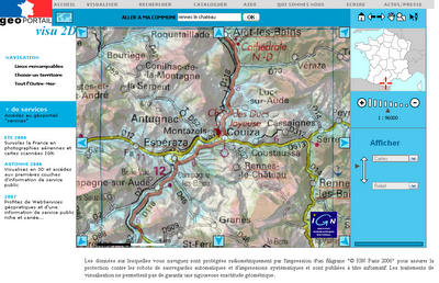
GeoPortail is finally here (kind of)! The very much hyped GeoPortail launched last Friday but has been down for most of the time because la demande était énorme. It now seems that the website is back up and available for all.
GeoPortail is the pet project of the Jacques Chirac and the France's National Geographic Institute. Government funds were pumped into the project so the Formage could feel good about beating Google Earth.
Unfortunately they will have to wait. While GeoPortail beats Google Maps it still lags behind Google Earth. It only covers France and French territories and only gives 2-D maps. The 3-D views are coming in the fall but until then Google Earth for me!

But enough bashing the site; let me discuss the good parts. The resolution in the countryside blows Google away! The crème de la crop is in the layering. Here one can choose to view (in certain areas) aerial photos, topographic or regular maps, road maps, and elevation relief. The neatest thing though is the ability to make the layers translucent and overlay on top of each other.
I eagerly await the full release of the product even if it is in French.
Category: Neogeography, Atlas

2 comments:
Using the "search" for the same term you did gives javascript errors, in both Firefox and IE :-(
Everything works now! :)
Post a Comment