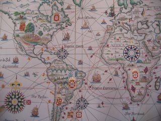
Nick Moles, fellow blogger and supporter of President James Polk, has a real interesting find of a map.
The map shows the New World divided between Spain and Portugal under the Treaty of Tordesillas. The iconography of the map is interesting. Arabs are seen in Arabia, a church in Africa show missionary efforts, and the great city of Timbuktu is depicted as having European architecture. I guess it was hard to recognize anything not having a European nature as great.
One problem Nick points out; however. Why does Quebec have a symbol of Portugal on it?
Category: Maps
1 comment:
Because of Portuguese expeditions to Greenland and North America before the treaty. If you take a closer look to the map under the coat of arms you see "Terra de Labrador" (Land of Labrador) and "Terra de Corte-Real" (Land of the Corte-Real) named after João Fernandes Labrador and the Corte-Real family. So the land was de facto Portuguese.
Post a Comment