Many thanks to FSSP for this post
Libyan War Maps
Syrian Arab Spring Protest Maps - Batch One
Syria Civil War Maps Batch Two - Syrian Air Defenses
Syria Civil War Maps Batch Three - Twitter and News Update Maps
Syria Civil War Maps Batch Four - The Soccer Map
Syria Civil War Maps: Batch Five - Ceasefire Violations
Syria Civil War Maps: Batch Six - Houla
Syria Civil War Maps: Batch Seven - June 2012
Syria Civil War Maps: Batch Eight - Battle of Damascus
Syria Civil War Maps: Batch Nine - September 2012
Syria Civil War Maps Batch Ten - October 2012
Syria Civil War Maps Batch Eleven - Propaganda Maps
Syria Civil War Maps Batch Twelve - First Quarter 2013
Syria Civil War Maps Batch Thirteen - Chemical Weapons Attack?
Syria Civil War Maps Batch Fourteen - Israel Strikes Again
Syria Civil War Maps Batch Fifteen - Second Quarter 2013
Syria Civil War Maps Batch Sixteen - The Coming Western Intervention
Syria Civil War Maps Batch Seventeen - Al Qaedastan in Iraq and Syria
Catholicgauze's Note: Political Geography Now now has a premium section with more detailed and updated maps. It is a bit pricey but if you want some very good analysis consider it.
The former al Qaeda in Iraq, now known as the Islamic State of Iraq and the Levant (sometimes translated as Islamic State of Iraq and Syria), has reached a climax. After expanding in Syria, in December it overran the Iraqi cities of Ramadi and Fallujah while also grabbing pockets of rural Iraq.
Political Geography Now has two great maps of Iraq and Syria showing places under ISIL control.
Political Geography Now's map of Syria matches what the BBC has.

It is interesting to see that even though ISIL controls much of eastern Syria, the control is not mirrored in western Iraq. ISIL cannot hold the Iraqi border area which is patrolled by the Iraqi army. Instead, it has lodged itself in areas of Sunni dominance with little overt Baghdad-military presence.
ISIL seems to have overstretched itself. In Syria it has angered other Sunni rebel groups, including the Syrian-al Qaeda branch known as al Nusrah Front, to the point these groups are taking ISIL strongholds in western Syria. However, in the eastern city of Raqqa ISIL is taking on the weaker rebels. Cedric Labrousse of The Arab Chronicle has made some good maps of the rebel alliance versus ISIL Syrian subwar.
Meanwhile in Iraq ISIL is engaging in a Sunni civil war between those Sunnis in power who have nominal allegiance to Baghdad and some of the smaller tribes who did not suffer under al Qaeda in Iraq's strict rule of Anbar province in 2004-2008.
Some, but not all, of the ISIL-alligned fighters declared an independent state in Fallujah. However, they did not define their borders. This has not stop those on Wikipedia on making their own map showing all of Anbar and ISIL-held Syria as part of this state in the "Islamic State of Iraq and Syria" article. This shows the limits of Wikipedia's usefulness as pure conjecture takes over.
Libyan War Maps
Syrian Arab Spring Protest Maps - Batch One
Syria Civil War Maps Batch Two - Syrian Air Defenses
Syria Civil War Maps Batch Three - Twitter and News Update Maps
Syria Civil War Maps Batch Four - The Soccer Map
Syria Civil War Maps: Batch Five - Ceasefire Violations
Syria Civil War Maps: Batch Six - Houla
Syria Civil War Maps: Batch Seven - June 2012
Syria Civil War Maps: Batch Eight - Battle of Damascus
Syria Civil War Maps: Batch Nine - September 2012
Syria Civil War Maps Batch Ten - October 2012
Syria Civil War Maps Batch Eleven - Propaganda Maps
Syria Civil War Maps Batch Twelve - First Quarter 2013
Syria Civil War Maps Batch Thirteen - Chemical Weapons Attack?
Syria Civil War Maps Batch Fourteen - Israel Strikes Again
Syria Civil War Maps Batch Fifteen - Second Quarter 2013
Syria Civil War Maps Batch Sixteen - The Coming Western Intervention
Syria Civil War Maps Batch Seventeen - Al Qaedastan in Iraq and Syria
Catholicgauze's Note: Political Geography Now now has a premium section with more detailed and updated maps. It is a bit pricey but if you want some very good analysis consider it.
The former al Qaeda in Iraq, now known as the Islamic State of Iraq and the Levant (sometimes translated as Islamic State of Iraq and Syria), has reached a climax. After expanding in Syria, in December it overran the Iraqi cities of Ramadi and Fallujah while also grabbing pockets of rural Iraq.
Political Geography Now has two great maps of Iraq and Syria showing places under ISIL control.
 |
| ISIL in pink |
 |
| ISIL in pink |
It is interesting to see that even though ISIL controls much of eastern Syria, the control is not mirrored in western Iraq. ISIL cannot hold the Iraqi border area which is patrolled by the Iraqi army. Instead, it has lodged itself in areas of Sunni dominance with little overt Baghdad-military presence.
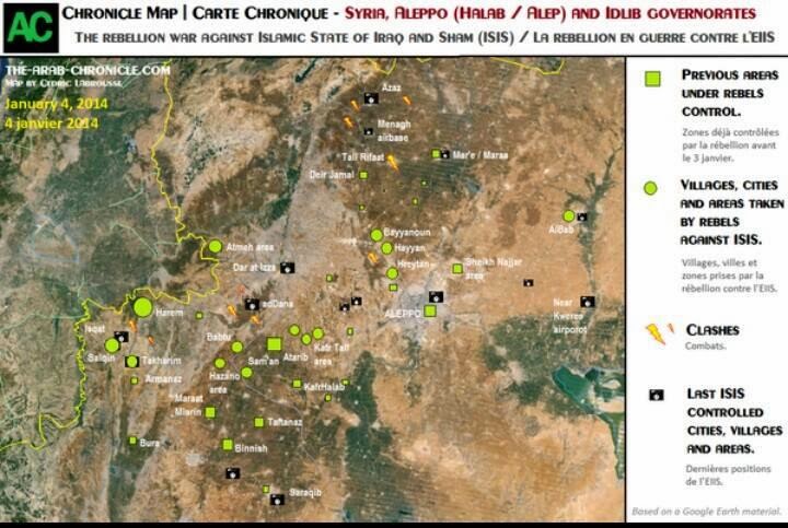
ISIL seems to have overstretched itself. In Syria it has angered other Sunni rebel groups, including the Syrian-al Qaeda branch known as al Nusrah Front, to the point these groups are taking ISIL strongholds in western Syria. However, in the eastern city of Raqqa ISIL is taking on the weaker rebels. Cedric Labrousse of The Arab Chronicle has made some good maps of the rebel alliance versus ISIL Syrian subwar.
 |
| Areas in western Syria lost by ISIL. From Twitter. |
 |
| Northwestern campaign against ISIL. Note how the government forces have not been defeated. From Twitter. |
 |
| North-central campaign. From Twitter. |
 |
| Raqqa counterattack by ISIL. From Twitter. |
Some, but not all, of the ISIL-alligned fighters declared an independent state in Fallujah. However, they did not define their borders. This has not stop those on Wikipedia on making their own map showing all of Anbar and ISIL-held Syria as part of this state in the "Islamic State of Iraq and Syria" article. This shows the limits of Wikipedia's usefulness as pure conjecture takes over.
 |
| Bad Wikipedia map. |
No comments:
Post a Comment