The Economist has taken a page from Strange Maps' US States Renamed For Countries With Similar GDPs map. The magazine has created three maps comparing each Indian states' GDP, GDP per person, and population to equivalent countries. The results reveal interesting and somewhat shocking insights into the world's tenth largest economy in terms of GDP.
The first map shows population. India is the second most populated country in the world and it shows. With states having similar populations as Brazil (5th most populous), Mexico (11th), and the Philippines (12th), India easily be thought of as its own world.


The first map shows population. India is the second most populated country in the world and it shows. With states having similar populations as Brazil (5th most populous), Mexico (11th), and the Philippines (12th), India easily be thought of as its own world.

Now let us look at GDP. It is clear that India's economy is primarily driven by Uttar Pradesh (Dehli) and Maharashtra (Bombay/Mumbai). Other states along the Indian Ocean and Bay of Bengal add to the overall economy. However, the interior of the country and especially the eastern states are much poorer. Nagaland, the majority Baptist state with a history of quasi-insurrection, has the same GDP as Zimbabwe and Tripura is on par with Somalia.

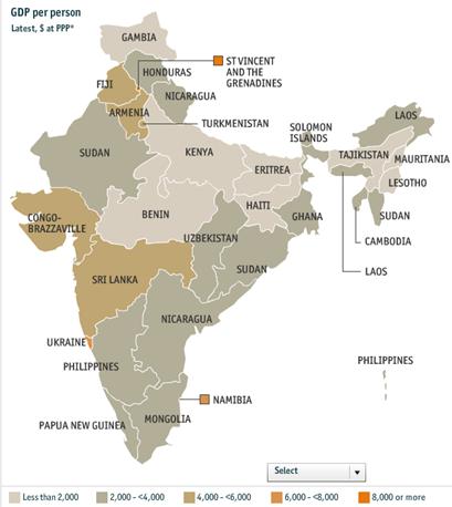
But while India's economy is huge we cannot forget that the Hindu giant also is filled with the poor, those left behind the great leap forward. When looking at GDP per person from just the GDP, the great Maharashtra falls from being a Singapore to become a Sri Lanka. Uttar Pradesh goes from a Qatar to a Kenya. The wealth of India is raising many boats of fortune but there is still much more economic growth to be accomplished.
No comments:
Post a Comment