Pages

Thursday, September 29, 2011

Extreme Weather Killing Less People

The libertarian but acknowledging human impact on climate Reason Foundation has published a detail report documingtin how extreme weather is killing less people since 1900.  Extreme Weather Events Are Killing Fewer People Than Ever Before states that deaths from extreme weather events are down 98%!

The decline is deaths is due to much more than warmer weather killing less than colder weather.  Death from droughts, which caused 60% of extreme weather deaths, is down 99.9% since the 1920s.  Meanwhile deaths from floods is down 98% and deaths from storms such as hurricanes and alike are down 55%.

Less deaths are happening due to extreme weather, according to the study
Interestingly though is the dramatic increase in events despite the drop in deaths.  The study states "the average number of extreme weather events recorded increased from 2.5 per year in the 1920s to 8.5 in the 1940s to 350 per year for the period 2000-2010."  The reason given for the contradiction is better communication and scientific reporting giving warning of events as well as economic development which gives better sheltering infrastructure.

Tuesday, September 27, 2011

Help Scientists Discover Extrasolar Planets

The explorers of old dreamed of new, strange lands beyond the reach of ancient ships.  The explorers of yesteryear dreamed of overlooked lands, the territories which we knew of but remained blank on maps.  Both these types of explorers wondered about lands which they could not see but could visit if only they knew the way.

But today's explorers can dream about lands which we can see but cannot visit due to the great space between them.  I am talking about planets beyond our solar system.

When I was born there was no scientific consensus on whether or not there were planets beyond our solar system.  Many thought there were but no one could prove it.  Now extrasolar planets are scientific facts and there are new planets found every month.  I have repeatedly blogged about the new discoveries and wealth of information available on these planets.

Now the discoverers of extrasolar planets need your help in finding these worlds.  Planet Hunter, a joint venture by Yale University and Zooniverse, is allowing anyone to look over sceintific data for signs of extrasolar planets.  The user is shown light intensity from stars.  If the intensity drops dramatically it is possibly from a planet eclipsing the light.  The user, once they identify the drop in light intensity, can simply drag and drop a box around the data to call for further scientific review.

Crowd sourcing technology is allowing for any computer user to become a geographer (astronomy was once part of the classic science of geography).  Whether one is helping National Geographic look for Genghis Khan's lost tomb or finding alien worlds, this is a great time to help explore the universe.

Monday, September 26, 2011

United States of [Insert Region Here]

When one thinks of the "United States" one most probably thinks of the United States of America.  The namely "translates" to "the union of countries on the American continent."  The name is that way because the original idea when founding the country was a federal system where highly autonomous units, basically their own country in terms of domestically, while united in international and interstate matters.

However, the United States of America was not the only country to be called "the United States."  There were others which shared federalism and in some cases freedom.

United States of Belgium

Both founded and collapsed by 1790, the United States of Belgium was the first sense of independence Austrian Netherlands (present-day Belgium) had.  The Enlightenment republic rebelled against the Holy Roman Empire's effort to centralize political control in the region.  The rebels modeled their republic on the Dutch Republic and the United States of America.  However, Austrian troops of the Holy Roman Empire managed to crush the rebellion within months.

Republic of the United States of Brazil

Unlike other United States, the Republic of the United States of Brazil was never a true democracy.  The elections were rigged and the republic was little different from the Empire of Brazil which the republic replaced in 1889.  The federal system was meant to give states freedom from the central government but the federal government was quickly usurped by oligarchs from the most populaces coastal states.  The republic eventually fell into control of President Getúlio Vargas who in the 1930s turned the country into the quasi-fascist New State.  The Republic of the United States outlasted Vargas, however, and existed until the military coup of 1964.

The United States of Colombia

This United States was the first iteration of Colombia to be called "Colombia."  The system was meant to give each Colombian state more autonomy in order to limit the amount of civil wars in the country.  However, the United States, which lasted from 1863 until 1886, was unable to stop the on-again, off-again fighting and was reformed as the Republic of Colombia.

The Republic of the United States of Indonesia

The Republic of United States of Indonesia was an effort by the Dutch to save face in the late 1940s after their defeat in quelling Indonesian rebels.  The United States were a combination of Sukarno's Republic of Indonesia, liberated Java and Sumatra, and various other islands which were established as states by the Dutch.  However, the states did not care of the Dutch established boundaries and dissolved themselves into the Republic of Indonesia within the first six months of 1950.

The United States of the Ionian Islands

The United States of the Ionian Islands were a British protectorate which was located off the western coast of Greece.  Originally a republic, it was first a Ottoman then French protectorate where Greeks enjoyed the first freedom from Turkish rule since the Ottoman conquests.  A British commissioner oversaw a local Parliament.  The United States lasted from 1815 until 1864 when they were absorbed into the Kingdom of Greece.

The United States of Venezuela

The United States of Venezuela was founded out of the Conservative versus Liberal war of the 1850s and 1860s.  The Liberals won out defeating the land-owning Conservatives and issued in an initial wave of land reform and decentralization, hence the United States.  However, like most Liberal parties of the old Latin America, the Liberals of Venezuela eventually became the new oligarchs.  The United States of Venezuela lasted until 1953 when military dictator Marcos Pérez Jiménez renamed the country to the Republic of Venezuela as an emphasize to his centralized control.

The United States of Stellaland

The United States of Stellaland was the union of two Boer, Africans of Dutch descent, republics: Stellaland and Goshen, formed in 1882.  The United States based much of its laws off the major Boer republic the South African Republic.  The United States was forcibly annexed by the United Kingdom in 1885 and eventually became part of Botswana.

Friday, September 23, 2011

New York Times' Geography of College Football

American college football went through a dramatic series of changes during its off-season.  Many of the major schools switched leagues, which were primarily based on geography, for leagues more equal in terms of competition.  The New York Times college sports blog The Quad wrote The Geography of College Football Fans (and Realignment Chaos) which examines college football fandom and how geography impacts fans and the leagues.  It is a great article which deserves to be read in its entirety.

Wednesday, September 21, 2011

U-Boat Simulator Game on Google Maps

"Sinking of a hostile armed troop carrier by German submarine in the Mediterranean sea" by Willy Stöwer.
Join the Kaiserliche Marine and bring the realm of King George V to its knees in Uboot-sim!  The game is Google Maps based (no installation needed) and allows players to command a fleet of U-Boats to pray upon British and Allied shipping in World War I (remember, you are fighting for imperialism against imperialism, not for imperial fascism against imperial quasi-democracies like in World War II).  This is a fun time killer.  The "geography" of the game is that the shipping lanes are accurate and can give one an idea of transportation routes and nautical choke points.  But mostly its just fun, enjoy it... for the Kaiser!  (Hat tip: Google Maps Mania)

Australian Geographic Articles Now Browsable on a Map

There is something in me that biases myself towards Australia.  I do not what it is, maybe it is my personal construction of Australia being a giant American Midwest and West on its own contentent  Maybe not.  Either way I know I really like learning about Australia.

The magazine Australian Geographic would be on my must read list... if I could afford it.  Sadly international subscription rates are extremely expensive no matter where one lives and there is no cheap online or kindle edition.

However, a collection of their articles are available for online reading.  What is even neater in the geographical sense is that one can browse through the articles via a Google Maps mashup on Australian Geographic's Explore Australia page.  Now is a great time to read up on all the articles you probably missed like a dispute over a T-Rex like dinosaur in Australia and the last horseback surveyors in Australia.  Enjoy the readings and have a g'day!

Tuesday, September 20, 2011

Times Atlas versus Reality

The new Times Atlas is coming out soon and has been making news for its recognition of climate change on Earth's geography.  The biggest piece of news was the atlas showing that fifteen percent of Greenland is now "ice free."  When I saw the map I could only think, "wow, I did not realize the changes were happening that fast and to that extent."

Alarmism versus Reality.  Image from the Daily Mail
The only problem is that the charges are not happening that fast nor to that extent, yet.  Scientists at the Scott Polar Research Institute at the University of Cambridge have written an open letter complaining to the atlas' editors about the errors in the maps.  While recognizing the impacts of climate change on Greenland the letter states "Recent satellite images of Greenland make it clear that there are in fact still numerous glaciers and permanent ice cover where the new Times Atlas shows ice-free conditions and the emergence of new lands."

Score one for reasonable scientists who have to combat alarmists in the battle for science!  Also of interest: the institute is part of Cambridge's Geography Department!

Monday, September 19, 2011

South Sudan Finally on Google Maps


View Larger Map

South Sudan finally on Google Maps on this day, 19 September.  The country declared independence on July 9th and was quickly added to OpenStreetMap.  It only take two plus months to make the move to a major commercial online mapping site.  Sadly the country is not yet on Bing Maps nor Yahoo Maps.

Abkhazia's Independence Struggle Mixes with Religion

Abkhazia is the de facto independent country which broke off from Georgia in the early 1990s.  The country was independent in almost every way possible.  The Georgians only held a corner of the country, a moderate pro-Russian presidential candidate defeated the Russian-puppet in an election, and Abkhazian laws prevented non-Abkhazs from owning real estate.

Things changed for Abkhazia at the end of the 2008 Russia-Georgia War.  Russia and a handful of countries recognized the independence of Abkhazia... at a very steep price.  Russian troops now control all border points in Abkhazia, Russian elites and businesses bought much of the famous Soviet-era resort properties, and there are countless allegations that many members of Abkhazia's parliament are now under Russian control.

Adding to the mess is Russian-proxy control of religion.  In the Eastern Orthodox Communion Abkhazia officially falls into the realm of the Georgian Orthodox Church.  However, in 2009 Father Vissarion Apliaa declared the "Abkhazian Orthodox Church" into existence and began to act as its interim bishop though he was never consecrated.  Since then Father Apliaa has imported priests from Russia with the help of the Russian Orthodox Church.  The independence of Abkahz religion was furthered threatened by Father Apliaa pressing the churches to drop Abkhaz in the services in exchange for Russian.

The arrival of Russian priests and the loss of the Abkhaz language in services, which the Georgian Orthodox Church always allowed, has led to a young faction of Abkhaz clergy to form a Church National Assembly
 to overrule the pro-Russian heads of the Abkhaz Orthodox Church.  This factor is rumored to be moderate in its stance in Abkhazian Orthodox church independence from Georgia and even has appealed to the Georgian Orthodox patriarch, as well as the thirteen other undisputed Eastern Orthodox heads, for helping in removing pro-Russian Abkhaz from the church.

The only problem is that the Eastern Orthodox lacks a pope and therefore no one can make a final judgement on the issue of Abkhazian Orthodoxy.  Eastern Orthodoxy cannot settle the issue of Orthodoxy in Estonia (Russian Orthodox v. national Estonian Orthodox), Ukraine (Ukrainian Orthodox pro-Russia v. two different national Ukrainian Orthodox), Macedonia (Serbian Orthodox v. national Macedonian Orthodox with the Greeks rooting the Serbs on) and Moldova (Russian Orthodox v. Romanian Orthodox) let alone issues of what if any Orthodox Church should be head of Orthodox in America.  The various churches are too nationalistic for rational discussion.

Abkhazia is not a overly religious country.  Orthodoxy never held massive sway over the population in modern times and various estimates given to me state there are no more than forty clergy in the country.  However, a country's national Orthodox church is something it can rally behind and becomes an issue of pride when a country feels threatened.  Look for Orthodox (and not-so-Orthodox) in Abkhazia to develop strong opinions concerning their Orthodox church and national independence

Thursday, September 15, 2011

Cartografia i Mon: Pretty Maps in Catalan

Foreign language blogs are tricky.  Not everyone, in fact only a minority, can enjoy the analysis of what the blog has to offer.  However, there are some blogs out there like La Cartoteca and the now sadly no longer updated ¡Mapas, mapas! which have such good images and maps that I will still recommend to people who cannot read the language.  Now the Catalan-language (the language of eastern Spain) Cartografia i Mon or "Mapping the World" joins the list.

The blog is written by Geographic Travels reader Jordi Francesch.  While the posts are in Catalan (which is sadly unreadable as my Romance Language abilities are pretty much limited to Castilian aka Spanish) the maps are in high quality and come in a multitude of languages including Spanish, English, and others.  Plus they are very pretty to look at.  Much of the cartography speaks for itself.  Check out this blog today and enjoy!


Wednesday, September 14, 2011

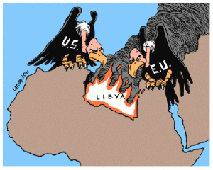
Libya War Maps: The Ninth Post - Propaganda Maps

Libya War Maps: The Eighth Post - More Battle of Tripoli Maps


Propaganda maps reveal stories that the cartographer wants you to think.  I have been looking at various pro and anti-Qaddafi maps and have found both themes have their own narrative.  I did my best to find maps from Libyan and Arab sources on their various Facebook sites.  While not all these maps may necessarily be made by Libyans or other Arabs, they have been embraced by them.

Pro-Qaddafi maps depict Libya as a vitcim that only Qaddafi can protect.  If he is gone outside forces would ruin Libya.  The war is portrayed as a foreign plot.


Anti-Qaddafi maps show Libya itself fighting off or consuming Qaddafi.  The war and Qaddafi's fall is shown as the work of Libya and Libyans themselves.


Tuesday, September 13, 2011

People's Republic of China Going Christian (Slowly)

What's the fastest growing religion in the People's Republic of China?  The answer is Christianity,  According to the BBC, the quick rise of materialism and capitalism in the officially atheistic Communist state is causing a wave of Chinese to seek comfort and solace in the God who humbled himself into humanity.  More Christians, 60 million (only five percent of all the People's Republic) attend church on Sunday than in partially secularized Europe.

The Christian religion is no stranger to China.  Both Nestorian and Catholics have created many converts only to be shut out by a xenophobic regime.  Then a missionary wave in the late 1800s began the conversion of many elites.  Several prime ministers of Japan were Christians.  A majority of South Korean and Republic of China Presidents were Christian.  Yet Christianity remained a small religion overall in Japan and Taiwan.  Now, however, Christianity is becoming a religion of the peasant, the worker, and the middle class like in South Korea.

The new converts are both Catholic and Protestant, both independent of the government and controlled by the government.  Protestants do lead with the rate of new conversions though.

No spatial data exists to map out the new converts.

Friday, September 09, 2011

Kosovo Votes for More Secularism, Becomes Third European Country to Move Against the Hijab

The parliament of Kosovo voted 43 to 39 to keep a ban against teachers and students wearing the hijab in schools.  The parliament further voted 64 to 18 not to allow religious education in public schools.  These votes demonstrate the desire of Kosovo's government to continue a path of Europeanization modeled after Turkey (which is now abandoning the secular, European vision for a neo-Ottoman model).

The ban is much like the ban in France and half the states of Germany.  The hijab and other Islamic veils are still legal and religious woman can still wear them except when they are teaching or taking classes.

The ban raises questions about the "otherness" of Islam in Europe.  Ruling Eastern European political parties in Poland and especially Hungary are taking very active steps to (re)emphasize the Catholic Christian nature of their European heritage.  Meanwhile the various Orthodox Churches have reengaged governments to various degrees in countries like Romania, Armenia, Georgia, and Russia.  However, Islam in Kosovo, which has been in the country for some 500 years, is still viewed as a hurdle to Europeaness.  Whether Kosovo adopts more French-style state secularism or can integrate its Islam with a European identity in a Hungarian model will be something to watch.

Thursday, September 08, 2011

Traffic Maps of Major United States Cities

Checking the morning traffic reports is a daily ritual for many Americans.  Some wait for the traffic report on the television news before they head out while others get their updates on the radio while they are driving to work.  Many local news sites have traffic reports for their metropolitan area but the coverage is limited and quality can be hit and miss.

Navteq, maker of GPS products, has a website of live maps showing traffic updates for several dozen American metropolitan areas.  The traffic map shows the intensity of traffic, number of incidents, road construction sites, planned events, and "jam" factor.  The data is high-quality and is the same data Navtez uses in the car GPS products.  This is an excellent resource for those who are interested in their daily commute, wish to study traffic flows, or who are just curious.

Wednesday, September 07, 2011

Maps of American and British Generic Stream Names

Map by Derek WatkinsClick to Enlarge.
Cartographic blogger Derek Watkins has created a fantastic map showing generic terms for streams in the contiguous (48 states) of the United States.  The map ignores, actually makes grey, the terms “river” and “creek” because of their near universal use throughout the country.  What is interesting are the other generic terms.  The application of terms reflects both cultural and physical geography.   For instance:

Kill - derived from Dutch is centered along the Hudson River.  This area was once the heartland of the New Netherlands.

Cañada, Arroyo, and Rio are found in the American Southwest, which was once part of New Spain.  Interestingly cañada, arroyo, and rio are separated from one another in their own clusters.   Cañada means “glen” and the use of the term reflects the rough terrain and the river-created valleys in present-day Arizona and surrounding regions.  Arroyos, intermediate streams and their sometimes dry river beds, populated dry New Mexico.  Rio is the rarest Spanish waterway term and reserved for major waterways like the Rio Grande.

Swamp is used in Southern states in areas where the coastal planes meet the Application Mountains.  In these regions the mountain rivers spread out and “swamp” the low lying lands.

In response Spatial Analysis UK made a map of generic stream terms in Great Britain.  

Map of British stream names by Spatial Analysis
The English-derived river dominates much of England and even northern Scotland.  A barrier of water provides a border between Scotland and England.  The Scottish term burn is scattered focusing primarily in remote and eastern regions of Scotland.  Wales remains cultural independent with its stream landscape with the Welsh term afon being by far the most popular in the country.

Tuesday, September 06, 2011

Syrian Arab Spring Protest Maps - Batch One

Libyan War Maps 
Syrian Arab Spring Protest Maps - Batch One
Syria Civil War Maps Batch Two - Syrian Air Defenses 
Syria Civil War Maps Batch Three - Twitter and News Update Maps 
Syria Civil War Maps Batch Four - The Soccer Map  
Syria Civil War Maps: Batch Five - Ceasefire Violations
Syria Civil War Maps: Batch Six - Houla   
Syria Civil War Maps: Batch Seven - June 2012    
Syria Civil War Maps: Batch Eight - Battle of Damascus 
Syria Civil War Maps: Batch Nine - September 2012 
Syria Civil War Maps Batch Ten - October 2012 
Syria Civil War Maps Batch Eleven - Propaganda Maps
Syria Civil War Maps Batch Twelve - First Quarter 2013

Syria Civil War Maps Batch Thirteen - Chemical Weapons Attack?
Syria Civil War Maps Batch Fourteen - Israel Strikes Again
Syria Civil War Maps Batch Fifteen - Second Quarter 2013
Syria Civil War Maps Batch Sixteen - The Coming Western Intervention
Syria Civil War Maps Batch Seventeen - Al Qaedastan in Iraq and Syria

Unlike the high quality maps of the protests in Cairo, Egypt or the numerous maps of the Libyan civil war, there are very few maps being updated showing the protests in Syria.  The Syrian protests lack maps and those maps that do exist are rarely updated.

Now Lebanon, a pro-March 14 news website, has detailed daily updates on the protests including location of events both big and small.  They pull from Facebook, Twitter, YouTube, blogs, and professional news sources.  On some days, like September 2, they create Google Maps mashup showing the day's events.

The Wall Street Journal has a map and links to new stories from mid-April up to July 8.

Normally fantastic al Jazeera has a map that was updated in July displaying Syrian map videos of the protests and their fallout.

Syria Unrest 2011 has a crowdmap which by far would be the best map of unrest but it suffers from lack of users.  There seems to be only five Syrians updating the map.