Did you know that half of all Britons have considered emigrating from the United Kingdom and thirteen-percent said they were hoping to do it in the near future? Those numbers, and especially the last one, are monstrously high. Europeans have said they dislike high unemployment, high taxes, and high cost of living. Places like
More examples are abound. Germans are leaving their fatherland looking for jobs. 145,000 Germans have emigrated last year amid record postwar unemployment, pushing emigration to its highest level since 1954. Right now unemployment in
All this is bad for
Thursday, August 31, 2006
The New Wave of European Emigration
Wednesday, August 30, 2006
Fellow Bloggers Update
Catholicgauze has some more recommendations on blogs to read.
Fantom Planet is done by a fellow geographer and contains the opinionated output about geographically related things.
Geography for Travelers contains blog posts and podcasts. Subjects covered obviously deal with travel, tourism, and travel geography.
Islamic Cartography is a blog which is the public face of Tarek Kahlaoui ongoing disertation on The Depiction of the Mediterranean in Late Islamic Cartography, from the 13th to the 16th Centuries. This one looks promising.
Finally there is Outsourced by Nick Moles. Nick is a Texan living in
Tuesday, August 29, 2006
Water wars or is the world just nuts?
A
National Geographic News is reporting on a conspiracy theory being advocated by some including Adolfo "US is a terrorist state" Esquivel which NG describes as an "activist" and Nobel Peace Prize winner. The South Americans allege the
I have participated in many discussions concerning anti-Americanism. Some of the people I have discussed the phenomena with tell me American policy is to blame. But these South Americans are just nuts. If a group based in the
Category: Geopolitics
Monday, August 28, 2006
Postcards to Catholicgauze: Louisiana
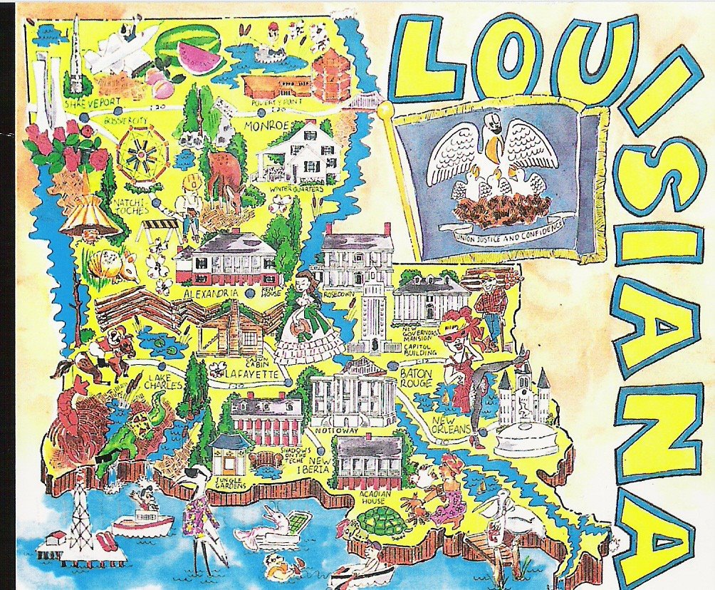
This past summer Catholicgauze received several postcards from friends. One of them was from
Studying postcards has long been a sub-section of geography. Postcards usually show how a town, region, state, country wishes to be seen and what the town, region, state, country considers important.
The
In the middle of the postcard a "Cajun cabin" and fence are seen expanding from the Toledo Bend Reservoir to the Mississippi River near
In both the northern and southern parts of the state antebellum plantation houses are seen and there is also a Scarlett O'Hara-type woman. The romanticism of the Old South is alive and well.
The only black person depicted in a state with 32.5% black population is a person practicing voodoo. Voodoo does have a rich history in
No where on the map are any war references. No War of 1812 and no Civil War sights are marked. When it comes to the Civil War the state's history is counteracted by the state flag with the motto of "Union Justice and Confidence."
Category: Postcards
Sunday, August 27, 2006
Space Tourism Continues to Grow (with Anousheh Ansari!)
Russia
Space Adventures has competition for Virgin Galactic. Virgin Galactic is the offshoot for the famous Virgin brand and managed by Sir Richard Branson. Virgin is making its own spacecraft (the first one being named the VSS Enterprise - go Star Trek!) and it will be based in New Mexico. Virgin will be receiving training aid from NASA. Plans are to launch 500 people a year into space starting around 2008. The price to go up in the VSS Enterprise will be only $200,000.
Right before Dennis Tito became the first space tourist there was some rumblings from NASA. It is this type of snobbish attitude which has distanced the public from space exploration. I say if one has the money and goes through the training then they should have the honor of becoming astronauts. What's so special about being hand picked by NASA: a failing government agency?
There is some interesting news about the latest space flight. Japanese businessman Disuke Enomoto was pulled off the flight because of health reasons. Maybe this was a good thing because he was planning on going up as his favorite anime character. His replacement will be American business woman Anousheh Ansari. Ansari was born in
As a homage to TDAXP and to honor a request by a female friend I offer pictures of the stunning Anousheh Ansari (or as TDAXP would put it "Beautiful, Hot, and Sexy Iranian Astronaut Pictures"). Just remember boys she is married! (Note: Done in good humor, Catholicgauze respects women; he just fails alot)


Category: Space
Saturday, August 26, 2006
Representations of Indians and US Army along the Oregon Trail: Kansas up to Topeka

After leaving
The first city one enters in
The Oregon National Historic Trail Auto Tour Route then takes a highway along side the interstate through Lawrence and passed Lecompton, sit of the pro-slavery capital of Kansas, and into Topeka; which is the capital of Kansas and served as the anti-slavery capital of Kansas.
In
The next stop is the Kansas State Historical Society Museum. The Museum is full of history from pre-Cambrian times to modern day. The Indians section; with everything from paelo-Indians of the
The main affront (and I may be completely wrong about this; further research is need) is the
The compensation was the Pottawatomie Baptist Mission near the museum. The mission museum shows what life was like for the Indian students who went to the school detailing duties, schooling, and showing off the rooms were their days were spent. The exhibits point out most of the students were mixed blood.
So concludes the brief time from
Category: Oregon Trail
Friday, August 25, 2006
Getting to know the Enemy: Islamist Fascism

“Know your enemy and know yourself and you can fight a hundred battles without disaster.” - Sun Tzu
Sun Tzu's words are very true. In this age of global struggle his advice is being used not only by military and political leaders but also by the average citizen who forms the base of any democratic society.
Because Catholicgauze is such an advocate of everyone being an informed member of society I offer these links which provide first and secondary information (some from the terrorist themselves) about these monsters who call themselves Jihadis.
The Combating Terrorism Center at West Point has a translated copy of The Management of Savagery by Abu Bakr Naji. In this horrible piece of literature Abu Bakr Naji outlines how Islamist terrorists should go into Muslim countries, kill all those who oppose them, and institute a fascist-style government. He cities numerous examples from
Little Green Footballs has some links to terrorist websites. The only one English-language in is Press Release. This blog contains the press releases (with information like praising allah for the deaths of innocent civilians) from the Mujahedeen Shura Council of Iraq. The council is an umbrella group of terrorists including al Qaeda in
Finally one should read up on Koran, which Islamist terrorists base their ideology on. CAIR offers a free Koran give away. I received one and was horrified by what I read.
End note: When I was talking about this blog post some asked why I was giving direct links to terrorist handbooks and propaganda. My answer is this: The terrorists already have access to this information; but if the Western citizen can see this primary information they will see the monsterism of those who oppose us. And the army agrees with me (PDF).
Category: War on Terrorism
Thursday, August 24, 2006
Review of Online Mapping Sites: Ask.com

Five points to he or she who sees the easter egg first
It's back. The long delayed review of online mapping sites continues. Ansiguy has been kind enough to review Ask.com's entry into the mapping world. Catholicgauze decided he could not be an impartial reviewer because of the whole "declaring holy war upon them for trying to astroturf me" thing. The review was originally posted here but I have copied it for my readers' convenience (but be sure to read TechPoint blog!)
Some of the popular mapping websites are Mapquest, Google Maps, Yahoo Maps, Mappoint, Ask, etc. While most of them source from Navteq or TeleAtlas; the way they are presented makes a huge difference in the user experience. Companies try to stay ahead of competition by doing something different. One common thing is to provide a feature that competitor’s don’t offer. But sometimes it leads to some interesting features such as ask.com’s map providing an option for walking directions.For walking in downtown New York or Chicago or big similar big cities this feature would be very useful and Ask.com is the only service that provides it.
An interesting direction would be 223 E Monroe St, Chicago, IL 60603 to 339 W Monroe St, Chicago, IL 60606. Compare between Driving directions and walking directions. Due to one way routes, driving directions are not the best to take if you plan on walking. Great!
I searched Ask’s map direction from Chicago, IL to Detroit, MI and just for the heck of it I clicked on walking directions and I found the time estimate as 125 hr. 20 min.
Now I would be curious to know who would walk so many hours?
The reason for my curiosity is Ask.com probably is optimizing routes for driving and walking, because the Chicago – Detroit driving directions shows a shorter route while walking directions shows a longer route may be due to the fact that you cannot walk on all the routes that you can drive.
Pretty much walking directions is the only feature that would attract you to Ask.com’s mapping site. There are no other standard features such as reverse directions which is a commonly used feature and available in other mapping sites.
Mapquest still stands as my top pick. Mapquest’s sole business is maps and they do a good job at that. Mapquest is the only service that allows you to perform advanced options such as Shortest Time, Shortest Distance, Avoid Highways , Avoid Tolls and Avoid Seasonally-Closed Roads. Mapquest may not be up to mark with the top notch technology such as ajax or flex, but they sure do provide good and accurate directions with some really good advanced options.
Related posts:
Yahoo maps beta released - feature rich
Google Maps Vs Mapquest - what’s your pick?
Wednesday, August 23, 2006
GEO Data Portal

Guess which region is has a large crude birth rate
The United Nations Environment Programme's GEO Data Portal is a very handy tool to access geographical and demographic data in map, graph, or numerical form.
The description on its website goes "The GEO Data Portal is the authoritative source for data sets used by UNEP and its partners in the Global Environment Outlook (GEO) report and other integrated environment assessments. Its online database holds more than 450 different variables, as national, subregional, regional and global statistics or as geospatial data sets (maps), covering themes like Freshwater, Population, Forests, Emissions, Climate, Disasters, Health and GDP. Display them on-the-fly as maps, graphs, data tables or download the data in different formats."
Category: GeoInfo
Tuesday, August 22, 2006
The Worldwide Water Shortage
Financial Times has an excellent article concerning water shortages around the world.
Fascinating points include:
870 gallons of water are used each day in
Agriculture uses 70 times more water than domestic use. The American Middle West faces a major problem with the slow but steady declining Ogallala Aquifer.
Man does not have a good track record with water management. The Salton Sea was once the Salton Sink. There was also once a thing called the
Category: Physical Geography
Sunday, August 20, 2006
Representations of Indians and US Army along the Oregon Trail: Independence

And so begins my project to blog my findings concerning my trip along the Great Plains section of the
Also in 1831 an event occurred which would herald the greatest intranational migration in American history. Four Flatheads Indians passed through
The
In Court
While the museum is a very nice place and very informative it lacks some necessary interpretation. The only depiction of the military is concerning the Mexican-American War. No solid mentioning of the famous forts of
At
No where to be found in the rest of the city were any more interpretations of Indians or US Army from the time of the
One of the oldest churches in town is Saint Mary’s Catholic Church which was founded as an Indian mission. Only a small marker tells of its past. Nothing inside the church could be found discussing its past. Why does the church not take pride with its past?
It is time to leave
Category:
It is Coming...
Clustrmaps

As readers have noted I am now using Clustrmaps to show where my readers are coming from. Clustrmaps provides maps of, well, clusters of users from general areas around the world. It is a pretty neat service.
People may also be interested in SiteMeter's mapping abilities. Site meter can map up to the last one hundred visitors (for free) to any website.
Category: Neogeography
Saturday, August 19, 2006
Virtually Visiting Ancient Egypt
Former volunteer and blogger Jason Clay has recently returned from
Category: Virtually Traveling the World
Friday, August 18, 2006
Map of The Simpsons' Springfield
Map of Springfield has section maps of the fictional city and a complete "big map" of the area which the show takes place in. Who remembers places like John Bull's Fish and Chips, Fort Springfield, and the Monorail?
Category: Maps
Thursday, August 17, 2006
Cryptozoology in Maine
Whether it is vampire-like creatures in New England or just plan weird things going on, I have a side interest in studying the "odd" things in the world. I feel the terms "supernatural" and "paranormal" have been corrupted (much like the term UFO which is now utilized in popular culture as "identified spacecraft from beyond this planet") so I prefer the term "odd." The problem is only two groups study odd things today: pseudo-scientists who are jokes and crackpots and debunkers who already have the conclusion settled before they begin studying. It would wise to investigate this field further, you never know what you may find.
Take the case of the monster of Turner,
Now there are other cases that should be solved. What was the Beast of Bray Road? It sounds like the Beast of Gévaudan sans killing people. And more importantly, what has been mutilating farmers and ranchers' cattle throughout the American West? In my grandfather's hometown a cattle was mutilated and no one could say what did it but they all knew it was not a wild animal attack.
Category: Miscellaneous
Wednesday, August 16, 2006
Geography of "We're All Going to Die!" ... or Maps of Disasters World Wide
ÉLETVESZÉLYES HŐMÉRSÉKLET! ÉLETVESZÉLYES HŐMÉRSÉKLET!
The RSOE Havaria Information Service offers human and natural disaster maps online. The maps are mash-ups which use Google Earth as the base. Each marker can be clicked for more information on the disaster. The markers flash in such a way one imagines it is the end of the world.
Currently maps of Hungary, Europe, and the World are available. Some disasters like "civil war" or "ethnic cleansing" are absent but most events are depicted.
Also viewable is the weather reporting system for picturesque Lake Balaton. Right now all seems well and it almost makes me want to leave the States to go on a sailing vacation. I qualify the previous sentence with the word "almost" because there is an epidemic of some horrible sort going on right near by in neighboring
Category: Maps, Neogeography, Physical Geography
Tuesday, August 15, 2006
European Railroad Maps
Traveling on any train can be a very relaxing experience. I have had the opportunity to and I greatly enjoyed it. Seeing the country side pass one bye in seats much larger than on an airplane all the while having the opportunity to get up and walk from car to car is a traveling rite of passage.
One of the main ways of traveling in
So what can make the railways of
Map Room Blog linked to an excellent collection of maps which show electrification, tourist lines, and others. I like this collection of maps because the cartography is simple yet elegant.
The technological and detailed awards go to RailEurope.com. They feature interactive flash maps of
Category: Maps
Monday, August 14, 2006
Geography and Games: Conflict

Conflict: Middle East Political Simulator is a computer game from 1990 but still is very timely.
The game's simple background story is that you are replacing the former Prime Minister of Israel who was assassinated. The purpose of the game is to keep Israel independent, not get overthrown but an insurgency, and topple all neighboring countries via invasion, insurgency, or have another nation conquer. One can buy an army, police the Palestinians, and work on
The game is a fun diversion (any round can be completed in ten minutes) but there are some geopolitical problems. If one gives the Palestinians independence the "Palestinian problem" is permanently solved. No more PLO, Hamas, or Islamic Jihad. If it was that simple I think we could have solved
That said Conflict is good clean fun. Can you nuke
Sunday, August 13, 2006
Ask.com caught! Crusade on them!
Last night Ask launched an astroturf campaign against the Catholicgauze. One "Jimmy O'Reilly" commented on TDAXP and then an "Anonymous" posted over on GTWC! quickly afterwards.
An investigation quickly revealed that "Jimmy" is an Ask.com comment spammer. The spammer has been busy on Yahoo groups singing the praises of Ask. He calls Ask.com maps "massive cool," and in the rest of his posts he goes out of the way to give credit to Ask.
Ladies and gentlemen: A very dishonest practice has been uncovered. This event has convinced me once and for all that Andy Yang (e-mail address: ayang@ask.com) has indeed lied to me when he stated on record that Ask.com did not blacklist GTWC!
I have made a chart comparing Catholicgauze, Ask.com, and Hezbollah (joking of course)
| GTWC! | Hezbollah | Ask.com |
| Anti-Terrorism | Pro-Terrorism | Never said anything against terrorism |
| Fights with a Blogger name | Hides amongst civilians | Hides amongst civilians |
| A leading general Geography blog | Only number 2 in terrorism | Wishes it was number 2 in the search engine game |
Geography and Books: Persepolis
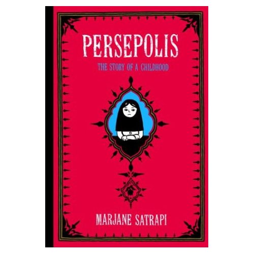
Persepolis by Marjane Satrapi is an autobiographical account of an Iranian girl and her parents’ lives from the end of the Shah's rule to the height of the Iran-Iraq War.
The book is a graphic novel and approximately 160 pages long. It was originally written in French but has been excellently translated into English.
Marjane was the great-granddaughter of the former emperor of
The most interesting factor in the book is the irony behind the Communists. Marjane grows up reading about Castro and Arafat, learns that
The book also serves as a reminder that most of the world has a much deeper sense of history than the
Category: Books
Saturday, August 12, 2006
Geographic Travels of Oil
The Chicago Tribune has an interesting series of articles in an investigation of oil geopolitics. It is hard to describe but worth a look.
It is important that one realizes oil is everything in this globalized age. As long as the world is dependent on oil it will be dependent on unstable regions only made worse with kleptomaniac governments. All the more reason to research alternative energy sources.
Category: Geopolitics
Friday, August 11, 2006
New High-Quality Earth Imagery from the ESA

The European Space Agency has announced that one thousand images are now available from their imagery website with most in TIFF format! My favorite is above but I am also partial to the one showing France and her neighbors.
I wish to give the hat tip to Spatial Ireland who will be joining the Catholicgauze Reads list!
Category: Physical Geography
Thursday, August 10, 2006
Ask.com Update
TDAXP has another report on Ask.com and its strategy. He compares Ask.com to the murderous, ungodly terrorist group Hezbollah. It is a fun read!
*********************************************************************
UPDATE: Ask.com caught!
Catholicgauze and the AAG
I know it is early but it is time to make plans. I will speak at the Great Plains-Rocky Mountain and West Lakes Division Fall 2006 meeting in
But more importantly I will speak at the 2007 Annual Meeting of the Association of American Geographers in San Francisco sometime between April 17 and 21.
Will any other bloggers or readers be there? I am already in communication with another blogger about meeting up and enjoying a drink together. Comment if anyone else is interested. Let us try to make something work!
Yet Even More Hezbollah Lebanon Israel War Maps

(For previous maps I posted check out the War on Terrorism Section)
I think Catholicgauze has been schooled. The Perry-Castañeda Library has THE collection of war maps. Included are day-to-day battle maps, general war maps, and maps of the countries involved.
Category: Maps, War on Terrorism
Salem Witch Trials
Exactly 200 years before New Englanders were battling vampires they were busy hanging "witches" (and by witches I mean their neighbors). The Salem Witch Trials were a bloody affair in which 20 people were executed and scores more imprisoned or accused.
Catholicgauze believes it is important to study this episode in
An excellent place to acquire information on the witch hunt is the
As a special bonus check out the map of Andover.
Category: Miscellaneous
Wednesday, August 09, 2006
Online Mapping Sites Review Comparison
Maps compared | Yahoo maps beta | Google Maps | Mapquest |
|---|---|---|---|
| Data | Navteq and TeleAtlas | Navteq | TeleAtlas |
| Technology | Flash/Flex | Ajax | Traditional |
| Drive from/Drive to | Yes | No | No |
| Multiple stop points | Yes | No | Yes |
| Categorized classifieds | Yes | No | No |
| Satellite | Yes | Yes | No |
| Reverse direction | Yes | Yes | Yes |
| Round trip | Yes | No | No |
| Points of interest | Yes | No | No |
| Send to cell phone | Yes | No | Yes |
Be sure to read Ansiguy's blog!
Category: Neogeography
Tuesday, August 08, 2006
Daily World News on a Map

Most international news websites have category lists where one can select news from a location. However, geographers (or at least I) have always desired to browse world news geographically. Now it is possible. Buzztracker allows one to scan the most popular places on a map and to view the stories.
Category: Neogeography
Monday, August 07, 2006
The Next English
***UPDATED STORY CONTINUES BELOW ORIGINAL TEXT***
In the ancient days the educated spoke Greek, in the Medieval era Latin was the international language, and around the Age of Enlightenment French was the Lingua franca. Now it is English's time. But in what form will English be the new international language?
The New York Times has an excellent short article on English being the new international language. While there is no doubt of English's dominance no one knows for sure what the English of tomorrow's world will exactly be. So the question is who's English will be spoken? Unlike Spanish with the Asociación de Academias de la Lengua Española or French with either the Académie française or Office québécois de la langue française there is no body which controls English and therefore there is no official version of English. With no one version of English one is left to wonder will the world spell the other word for hue as "color" or "colour"? (-Hint freaking hint you grammar monsters!)
There is a third way the new international language could go. There are several versions of the English language which were created specifically to aide in communication with non-native speakers. With English being so complicated with both Germanic and Romance influences, a simplified, artificial English may be the best way to have non-native speakers interacting in the globalized world.
Basic English is one of the oldest artificial dialects. With 850 words Basic English seeks an easy, simplified system. As of today some international companies like Caterpillar use forms of Basic English to write and communicate internationally. "Easy English" is another derivative of Basic English which is being used to make simplified translations of the Bible. Nothing beats Deuteronomy 1:14 "You answered me, '"That is a good idea!'"
Special English is used by Voice of America. Special English has a limited vocabulary, eased grammar rules, and is read slowly.
Globish is the "open source" of international Englishes. Starting off with 1,500 words Globish seeks to be defined not by grammar rules but by use. The creator of Globish is a Frenchman by the name of Jean-Paul Nerriere (a surprising fact when one considers who xenophobic the French have been with English words slowly appearing in everyday use). Nerriere has humorously explained in both American English and Globish why he thinks his version of English is better as a language of international communication.
Globish actively seeks to become an international business language. I do see some problems however. With no strict guidelines the language is doomed to fracture and schism like an evangelical church suffering scandals on Pentecost. (And I just do not see myself or anyone else praying the Globish version of Our Farther and "Hello, Mary.")
If the American dominance of English continues look for the downfall of civilization. It would not be the English one heard from the read letters of Ken Burn's Civil War but the "English" spoken and utilized by teenage girls! Teenage girls "are the most dominate force in the evolution" of my mother tongue. That's like totally like not cool.
Category: Languages
Sunday, August 06, 2006
Old Maps on Flickr
Category: Maps
Saturday, August 05, 2006
National Geographic's Pro-Castro Bias
National Geographic has been a huge asset to the
During World War I, World War II, and the early parts of the Cold War, National Geographic provided in-depth reports about the global geopolitical struggle. Those days are over.
National Geographic News has a story praising Fidel Castro as a conservationist. Stay with me and try to stop your head from exploding.
"[
"Students in every department at the
and
"As a result, many of
"So what will happen if Castro's regime falls and a new, democratic government takes root? Conservationists and others say they are worried that the pressure to develop the island will increase and
"One could foresee a flood of extractive industries jockeying for access to mineral and oil leases,” -Do some research! Castro is selling rights right and left.
I love the environment as much as anyone else. However, to write love pieces for Castro is low. If Castro had the chance
More on Global Warming
Self-declared prophet and weatherman Pat Robertson says he believes in global warming because it is hot outside. No matter what one believes about global warming (believes is the right word; very few do research on both sides of the debate) using day-to-day weather is a bad way to reach conclusions about climate change (and having Pat Robertson on your side does not help either).
For over the past one-hundred years scientists have been claiming the world is either getting warmer or colder. The 1920s and 30s were unusually warm and dry to the point dust bowls were common in the American Midwest. The heat wave of 1930 was hotter than the current one in the
But in the 1970s things changed. Global Cooling became all the rage. Time Magazine even published an article about the chances of another ice age. Things flip-flopped again in the late 1980s with Global Warming. Now in the late 00's evidence is showing that global warming is happening on other planets.
So what am I trying to say? I am trying to show that "scientific consensus" has changed over time. Climate change may or may not be real. The climate may be in a flux period or it may be in a correction. What causes climate change is also unknown. Finally, how many times have we heard it is too late. Why seriously handicap the economny and world development if the ship is doomed. Everyone needs to calm down and take a second look at things.
The major problem lies with people who get so wrapped-up in the issue and harden their hearts to other points-of-view. When I was at Harm de Blij's National Geographic Lecture some people were vocally enraged afterwards when de Blij (a believer in climate change) did not agree with the belief global warming is solely man-made. Some environmentalists make the environment their religion and those who dissent become heretics. On the other side, those who do not even consider another Little Ice Age-type era risk being caught without a contingency plan.
Category: Physical Geography
Friday, August 04, 2006
Europe Jokes
Exhales breath... What can I say about
Fromage, Cheese Eating Surrender Monkeys! In the last few years
There are two
Deutschland has suffered a fall from grace and is still recovering from the whole nasty business. One of its negative legacies is the Neo-Nazi movement. However, did you know that Neo-Nazis are people too and have problems we can only begin to understand?
Russian Jokes tend to be either self-hate or jokes at the cost of other groups in the multi-national republic. Who can forget the classic, "What did the New Russian say to the Old Jew? 'Can I borrow some money, Dad?'" This is why I favor humor not done by Russians (except for Yakov Smirnoff). All I know for sure is that I am taking back my Communist Monopoly game before the KGB agent gets cranky.
My loyal European readers (comment dang you!) may be asking "But Catholicgauze, what about humor at the expense of
Hat Tips to TDAXP, Curzon, Younghusband, and Younghusband again
Thursday, August 03, 2006
Virtually Visiting the Beijing’s Forbidden City
TDAXP may scuff at me but I will promote the chance to visit the Forbidden City without dying of poisonous air. The Beijing Guide has a section of its website devoted to the
Category: Virtually Traveling the World
Tuesday, August 01, 2006
¿Una Cuba Libre Pronto?
¿Castro está muy enfermo o está recuperando? No sé, pero yo conozco que... things are going to change in Cuba soon.
Fidel Castro has been a trouble some thorn in the side of Americans and democrats worldwide. At first he was seen as a liberator against a corrupt government. However, he quickly turned out to be a leftist monster. Pro-democracy, the religious, union members, and even homosexuals (search for "homosexual" in the article) were common targets for arrest and sometimes even execution. Freedoms were squashed. The era of Castro is the era of refugees. It is no wonder why so many oppose Castro.
Recently Castro went under the knife to stop internal bleeding giving most of his power to his brother Raul Castro. When news of this was released internationally there were celebrations in Miami and calls to break out the cigars in celebration of Fidel's flirting with death.
It is a little too early to celebrate- there is work to do. Bush has stated there are plans in place to aide a post-Castro Cuba. Catholicgauze has his own recommendations:
It is key to help the people and hurt the government as much as possible. I recommend that the embargo be lifted once Fidel is out of the picture and have business setup shop in
While the above is just a standard Catholicgauze rant; I think we can all agree having a real life Hidden Agenda would be horrible and must be avoided at all responsible cost.
Category: Geopolitics
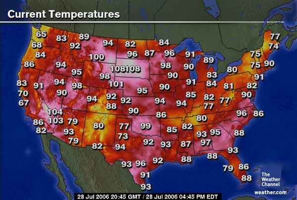
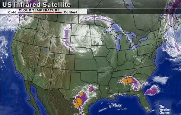
South Dakota Weather