Fellow blogger Vital Perspective has a map showing the targets the IDF is aiming for in Beirut.
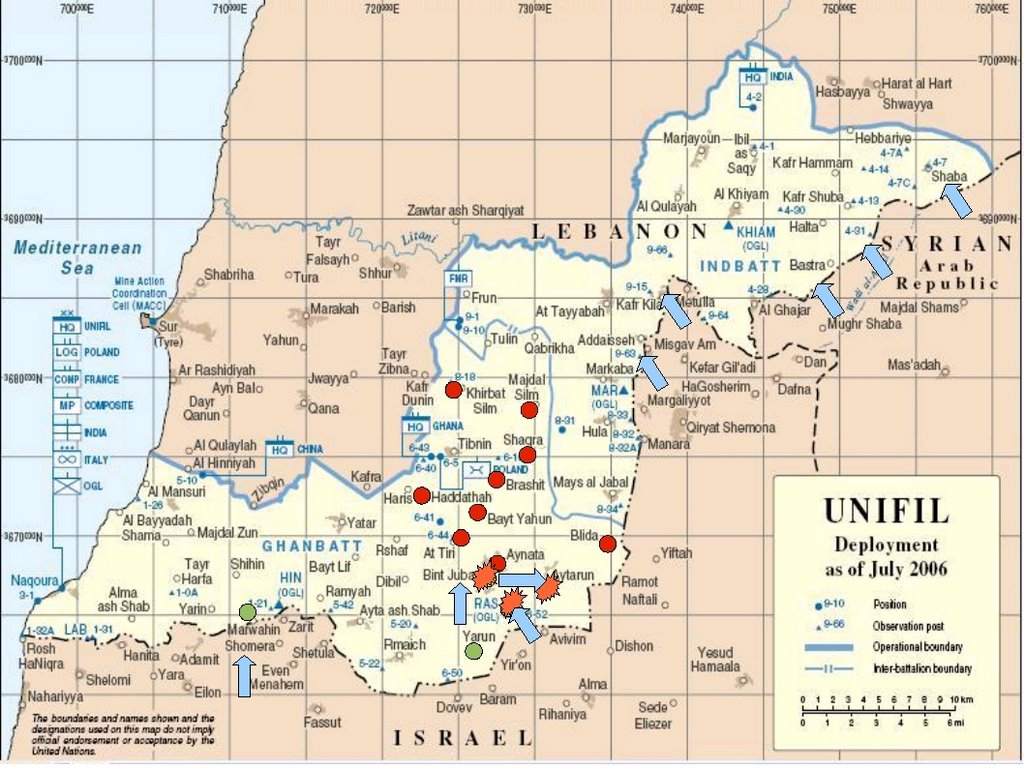
I have map a map showing where Hezbollah is targeting the UN troops there or using the UN as cover.
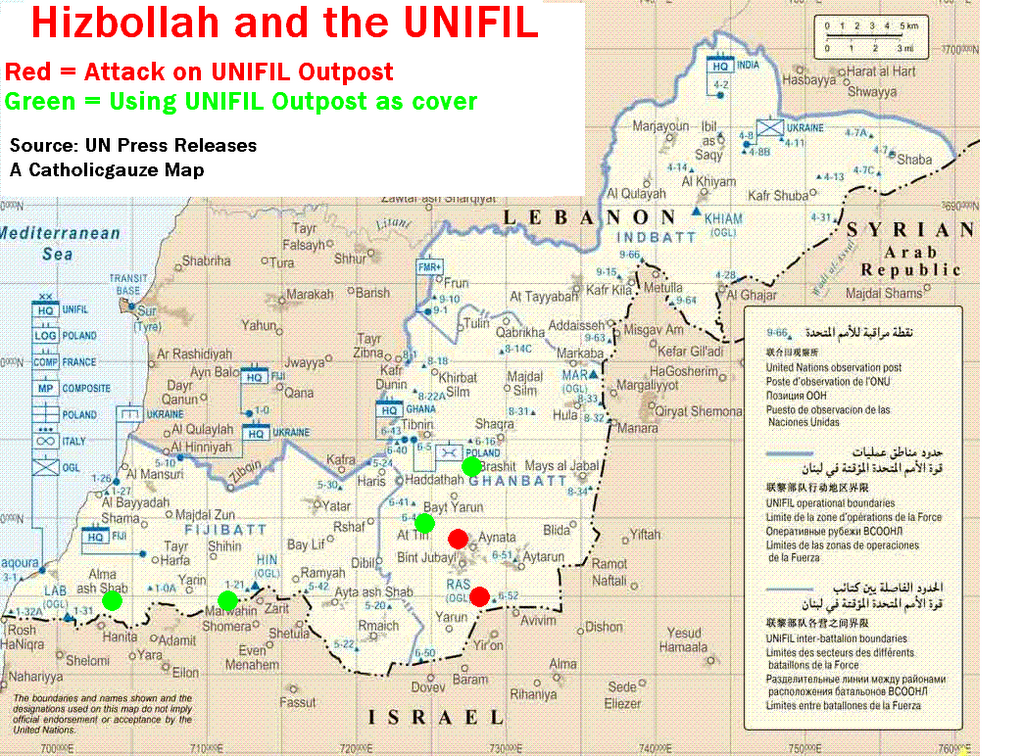
Click to Enlarge
Category: Maps, War on Terrorism
Today's internet find is a project with amazing potential. WikiMapia can be summed up as a geographical encyclopedia with articles placed on the Earth (kind of like Catholicgauze's Atlas).
With WikiMapia anyone can edit or add places to the Google Maps mashup. It is just getting started so many places need to be added or expanded upon. But do not let the sparse, out zoomed initial page fool you; be sure to search for cities to see how in-depth WikiMapia really is.
The only problem I have noticed is that latitude and longitude are interchanged. This is a cardinal sin which upsets Catholicgauze.
Catholicgauze supports his fellow geographers so I believe it is important to direct my readers to the Give Geography its Place campaign website. The GGiP effort seeks to raise the profile of Geography as an academic subject in all forms of the media and increase awareness of the importance of Geography and the vital role that it plays in schools, colleges and universities in preparing young people for the complexities of life in the 21st century.
I have three proposals to increase geographic knowledge throughout the world.
1) Popular Geography
Writing academic works is nice but there is a tendency for scientists to babble amongst themselves. If we wish to tell others about the joys of geography writing works that interest the public should not be viewed as a cop out but as important as writting academic work. Think about the old National Geographics from the 1950s and earlier. Others like Harm de Blij have proven works can be excellent while written in a form anyone can understand.
2) "Geography Can Save Your Life!"
Young Tilly Smith proved this while on vacation.
3) Terrorism
We will practice selective annihilation of officials and other academics for example to create a vacuum, then we fill that vacuum, as popular war advances greater geographical appreciation is closer. (Just kidding kids. Remember what CG always says, "Terrorism just ain't cool.")
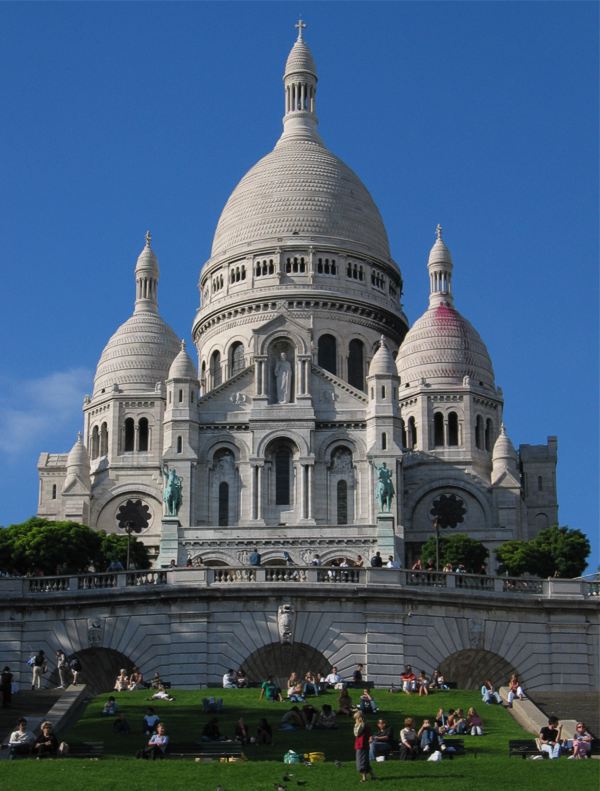
The Basilica of the Sacred Heart (Basilique du Sacré-Coeur) is a church in
The politics behind the church go back as far as the Age of Enlightenment. Conservatives and Monarchists were tied with the Roman Catholic Church as symbols of authority and the status quo. Liberals and radicals opposed the Monarchy and there for the Church as being oppressive against them and the people. Things came to ahead during the French Revolution where radicals were violently anti-clerical and attempted to stamp out Catholicism from
The revolutionary government was eventually done away with and for the next 70 or so years
Two very different reins would affect the outlook of French Catholics. Napoleon III stabilized State-Church relations until he committed the "forgivable" sin of withdrawing French troops from the Papal States thus leaving it open to Italian unification. During (or after depending who you ask) the Franco-Prussian War,
Catholics in
Liberals and radicals oppose this however. They objected to the symbolism which they saw as a monument to the old ways. Radicals saw it as an affront to the memory of the Communers who were executed on the hill. After efforts to stop building the church failed by legislative means many proposed the government a statue of liberty (the first one was being built for the
The church influenced the French middle at the time. Groups were encouraged to donate funds to construct chapels in the basement. One of the groups born out of the fundraising was a society of Catholic industrial workers. These were religiously devout Catholics who also supported social justice and other social causes. In 1899, Pope Leo XII rededicated the Sacred Heart to racial harmony, social harmony, and conciliation. This allowed Christian Democrats and other Catholics who did not support the Monarchy to support the idea of the Sacred Heart church.
Final consecration was delayed until the end of World War I. There was a huge celebration for the church and the French victory. For a while church's political statement lessened until the days of French radicalism returned. In 1971 radicals attempted to storm the church because they believed it was a symbol of government oppression. Later that year a small bomb went off exactly 100 years to the day of the execution on the Communers. Things have settled down once again. However, to this day the church is a controversial piece of the French political and cultural landscape.
A medieval Christian book has been discovered in an Irish bog. The book is a copy of the Book of Psalms and is 1,200 years old. The book is a wonderful historic find and can give a greater appreciation of the monasteries in
In a kind of weird and scary bit a trivia the book was open to Psalm 83 which describes a multinational effort to destroy

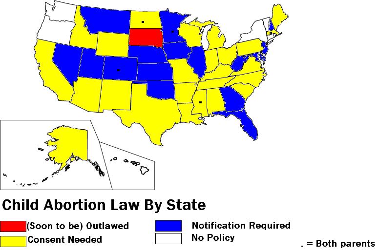
The United States Senate has just passed a bill making it a crime to take a minor across state lines to get an abortion without the minor's parents' knowledge.
The issue is an issue because various states have differing laws when it comes to a minor obtaining an abortion. The above is a map of the many different positions taken by states. The information has been confirmed by several sources on both sides of the abortion debate.
The people of
Category: Maps
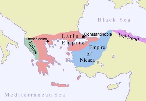
745 years ago today (July 25, 1261) the Empire of Romania, the attempted Catholic successor-state to Byzantium, the Eastern Roman Empire, fell to Michael VII Palaiologos.
In 1204 merchants in
After years of fighting the Greeks of Nicaea were able to defeat the invaders and restore the
In a twist of irony Michael VII's rise to emperor restarted the fall of the empire. He withdrew troops from Asia Minor to fight wars of reunification in
The Turks took
Category: Historical Geography
Note: Having some trouble with the hyperlink. Enter "http://mast.mcafee.com/default.asp" into the URL to see the map. - CG
McAfee has a map of computer virus infections around the world. The map is surprisingly customizable as it can depict the number of infected files, infected computers, infected files per million citizens, and infected computers per million citizens.
The Western Hemisphere and most of Europe are full of viruses while
Category: Maps, Neogeography

This post is dedicated to some of my friends who have never played "
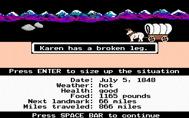
Oregon Trail has a cult following in my generation. It was the game to play beating out others like Wolfenstein 3D (I remember when my computer teacher gave us all copies), Secret Weapons of the Luftwaffe, and even Life and Death! Many others like Gamespot and Gamespy consider the game one of the greatest ever made. I agree with them.
The purpose of the original Oregon Trail game was to journey from
I learned about many sites along the trail from this game. The game is also my inspiration for my current study of the trail. It is a worthy addition to any educational program involving United States History.
The highlight of the series was
Afterwards three more
The original Oregon Trail can be downloaded here while the deluxe edition (colorful graphics) can be download here. Enjoy and have fun with the tombstones!
Geography@About.com links to a LiveScience.com report on the migration patterns of humans around the world (excluding
The world's population is migrating to the coasts especially in third-world countries. "This type of migration will expose 2.75 billion people to coastal threats from global warming such as sea level rise and stronger hurricanes in addition to other natural disasters like tsunamis." Wow.
The Americas map shows steady growth with some loss in the Great Plains, Appalachian Mountains, bits of Haiti, and pockets in South America. The Old World map has a few "OH MY GOSH!" moments when one views the depopulation of Europe and westernized
Category: GeoInfo, Maps
The Cato Institute has a map of botched "paramilitary" police raids in the United States. The map shows deaths of innocents, death of police officers, death of nonviolent offender, raid on innocent suspect, other "excesses", and "unnecessary raids on doctors or sick people." The map is interesting and provides information on each mashup.
Cato is big-time libertarian. While I agree with them that police can be excessive; there are many times when cops need SWAT teams. The streets of DC,
Category: Maps
The election mess is still going on in
The New York Times has its own break down of the election results with the political geography behind it.

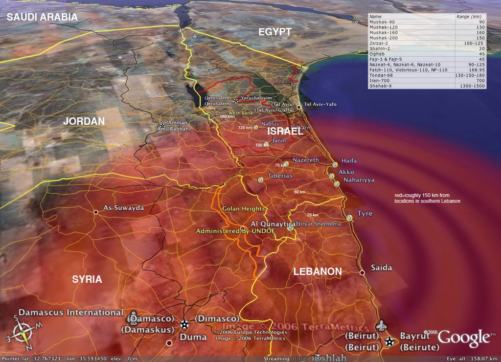
The BBC has a map with information on the key flashpoints of this war. The map shows areas hit by Hezbollah (Hizballah / Hizbollah / Hizbullah) and
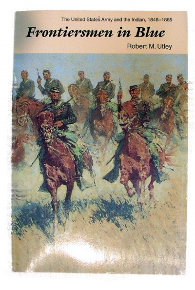
I just got done reading Frontiersmen in Blue: The United States Army and the Indian, 1848-1865 by Robert M. Utley and I simply must recommend it to anyone interested in American, Western, or American Indian history.
The book pulls describes how the United States Army primary purpose from 1783 to 1865 and for a while longer was not keeping foreign armies at bay but protecting western expansion, keeping the peace between whites and Indians (both ways), and building western infrastructure.
The books pulls no punches in the describing the triumphs and tragedies that occurred out west. Congresses unwilling to pay the price for Manifest Destiny, bureaucratic infighting between the War Department and Department of the Interior, corrupt Bureau of Indian Affairs Agents, overly aggressive army officers, and Indian chiefs unable to control their warriors all led to a series of problems in the Great Plains.
Peace was surprisingly maintained. Only about 200 engagements were fought past the
Details are abound in this book. The events before, during, and after the Battle of Ash Hollow are described in detail. Conflicting signs along the
Final thought: a fine book on American history.
Category: Books
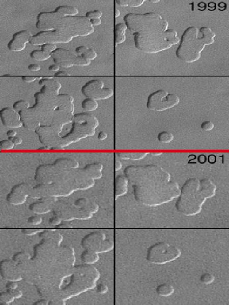 Proof of Global Warming on Mars?
 Global Warming is the hot scientific topic right now. The lines are drawn between Al Gore and those who disagree (ranging from no global warming to not as bad as Al Gore claims).
But there is something no one is disagreeing on: global warming is real... on Mars! Scientists are now leaning towards the opinion that the polar ice caps on the war planet are comprised of ice rather than carbon dioxide. The ice caps are showing strange pockets that are becoming bigger. This is probably being caused by global warming. A full NASA report sums it up much better than I can.
Triton,
The reasons behind solar warming may be because solar activity is on the rise.
These are all things to seriously ponder as we wonder what, if anything can be done about global warming. (Hat tip: Gateway Pundit and Stingray)
Categories: Physical Geography, Space
I recently looked over the world happiness index and it made me unhappy. But first a little background information is needed.
The WHI "balances" life expectancy, life satisfaction, and "ecological footprint." A ranked list of the countries by WHI and an interactive map are available.
The problem with the ecological footprint enters in the picture when
Here's part of the list with my thoughts (links go to CIA World Factbook)
1.
2.
6.
China - 56 - No words need
East Timor - 52 - Still in the top tier without a government, that's a triumph
Haiti - 43.3 - Getting close to the middle of the list
Spain - 43 - How the heck did they lose to Haiti?!? Red flag alert!
France - 36.4 - I knew being full-blooded Formage was bad but dang
United States - 28.8 - That explains why Americans are emigrating all over the world; wait...
After review the travesty of a list I tried my personal happiness index. My index number was 42.4 which I was told is the same as
The
Today's update:
I have read in the past how guerilla style warfare is the wave of the future. Now we are seeing guerillas using unconventional means to fight conventional over territory and seas. How this plays out will impact the future of warfare immensely.
 "I will execute great acts of vengeance on them, punishing them furiously. Thus they shall know that I am the LORD, when I wreak my vengeance on them" -Ezekiel 25:17
The past week has been Hell in the
The gloves are coming off and it is important to know what is going on.
Lebanon is the newest front in the War on Terrorism.
The news from
Syria has been a very bad boy. Right after the Iraq War ended a Syrian foreign minister said "
Iran is BAD NEWS. How bad you ask? Let's try APOCOLYPSE bad. President Ahmadinejad is hell bent on getting nuclear weapons and funding groups like Hezbollah. The people of
Operations in
For up-to-date information on what exactly is going I recommend Jerusalem Post, Strategy Page, YNet News, and Pajamas Media. For maps: Lebanon, Middle East, and Syria.
Category: War on Terrorism
Remember the cool link I had to a website which mapped last names in Great Britain? Well this post will blow that one away!
Now one can find out the distribution of last names in:
Have fun! See where your ancestors came from! (Hat tip: The great Cartography)
Category: Maps, Miscellaneous
Global Positioning Systems (GPS) is everywhere these days. Businesses like the transportation industry, government, and even average people are utilizing the ability to locate there exact position on the earth.
When most people say GPS they actually mean NAVSTAR GPS which is run by the
Galileo is the new system on the block. A product of the European Union and European nationalism, Galileo's main purpose is to free
William Shakespeare is one of the best playwrights of all time. Many people know that Romeo and Juliet takes place in
While some consider him an archaic relic of a bygone time; he was made the transition of the neogeography age well. The Globe Theater can be installed into Google Earth or explore the mentioned places in Google Earth.
Finally, Google has a website with his complete works and links to more fascinating Shakespeare stuff.
The unholy trinity of monsters of the twentieth century goes Mao, Stalin, and Hitler. Mao's plan was focused on changing Chinese culture and Stalin was more of a thug than an ideologue. Hitler; however, had plans when it came to the rest of the world. While many people know about Mein Kampf Hitler had a second book. This one, named "Hitler's Second Book," described Hitler's foreign policy.
Here is a good point-by-point of Hitler's plot with commentary and historical results.
Step 1: Alliances needed to be made.
In the real world Hitler got one out of two as allies. He was disappointed by the outcome.
Step 2: The Roman-Aryans Axis would take down France and any of her allies like
The real Italian-German axis took down
Step 3: In Mein Kampf Hitler claimed the Soviet Union was
Never get involved in an Asian land war! I have learned that too many times in board games and Hitler should have known that. "That's Stalingrad; you wouldn't have any fun in
Step 4: It is not discussed in the Second Book but Hitler talked about forming a "European union" which would primarily benefit
Today's scorecard: European Union - check! Hitler as victor - blank.
Step 5: Hitler had nightmares of a sort of anti-Christ anti-Aryan state. He feared a country populated by Aryans but "controlled by Jews." This country was the
I bet Hitler really wished he had
Hitler order the book to be held in secret because openly publishing "I will destroy
This is a Catholicgauze rant. Feel free to skip over it if you wish
As I wrote before I have a plan to fix
Before we start off here are some givens:
First off the immediate deadly conflicts need to be ended. Whether by an international coalition force (the
The second step is to rebuild governments. This will be a long, several part plan starting off from pure imperialism, to transitional joint-government, to complete independence. The occupation government should be filled with people from political backgrounds (State Department-types), military types, and allied non-corrupt Africans.
The third step is also the first step for countries that need not be overthrown. It is also the main part of the new imperialism. It is an infrastructural imperialism. The political structure can be 100% native but all aid and infrastructure should be handled by foreign powers. This will be the condition of receiving any aid at all. The controlling power can be political countries or trusted groups like the Red Cross or Catholic or Anglican Church. Clinics, schools, roads, etc. at first must be in the hands of those who know how they can be operated. Eventually, the foreign civil servants can train natives to be their replacements.
While the infrastructural imperialism is in place the political overhaul should continue. Corrupt officials must be dismissed. The native armed forces should be built up so the government and foreign civil servants can be defended without foreign intervention from those who would try to destabilize the country.
Also at this point the AIDS crisis needs to be addressed. The deadly disease is being spread not only by horrible health conditions but also by bad cultural practices. In some areas of sub-Saharan
The end result on a case by case basis should be a more efficient government with a much healthier society. It is much easier said then done but people said the same thing could not be done with
The test countries, if successful, can then become key players in expanding nation building imperialism to neighboring countries. In short, a sort of domino effect.
Is the plan perfect, no. Are there other plans to heal
Category: Geopolitics

Windows Live Local is Microsoft's entry into the world of online mapping sites and it is a decent one at that.
User Friendliness
Everything screams Windows user friendliness. The logo is that of Windows XP and the light blue hues are reused. Simple text boxes and easy to understand tool bars guide users. Third mouse button scroll is supported. To recenter one needs to right-click because a regular left click does nothing.
The zoom control is disorienting however. The image will become fuzzy then there is a load time to restore focus.
Driving Directions
Windows Live Local did standard on the long-term driving test. At the end it gave me directions which were slightly longer than they needed to be. However, directions were super clear and easy to understand. Also, information like "Entering Nebraska" was given.
The short term test was impossible to do. The street information of
Map Quality and Quantity
The map quality is above average. Things are clearly labeled and drawn. However, at high views everything looks like different shades of the same color. The aerial view is nice and Microsoft is not shy about using black and white DOQQs. The imagery in some places is dated though and lags behind Google's database.
Maps and directions are available internationally. Detailed instructions were given for a
What sets Windows Live Local is "bird's eye view." This is a very detailed and angled aerial shot. It is limited for certain cities. One nice thing is that the direction can be changed; for example, south can be at the top of the screen. However, scrolling is forbidden and the reorientation is not available for the map or aerial views.
Extras
It is clear Microsoft has much in mind for Live Local. Mash-up technology is in place and can be used in Microsoft's version of MySpace. Traffic is much better than Yahoo's. It is easy and customizable to share, print, or save maps and directions.
Summing Up
Microsoft has a potential winner on there hands. A little more tweaking and who knows what they can do with this.
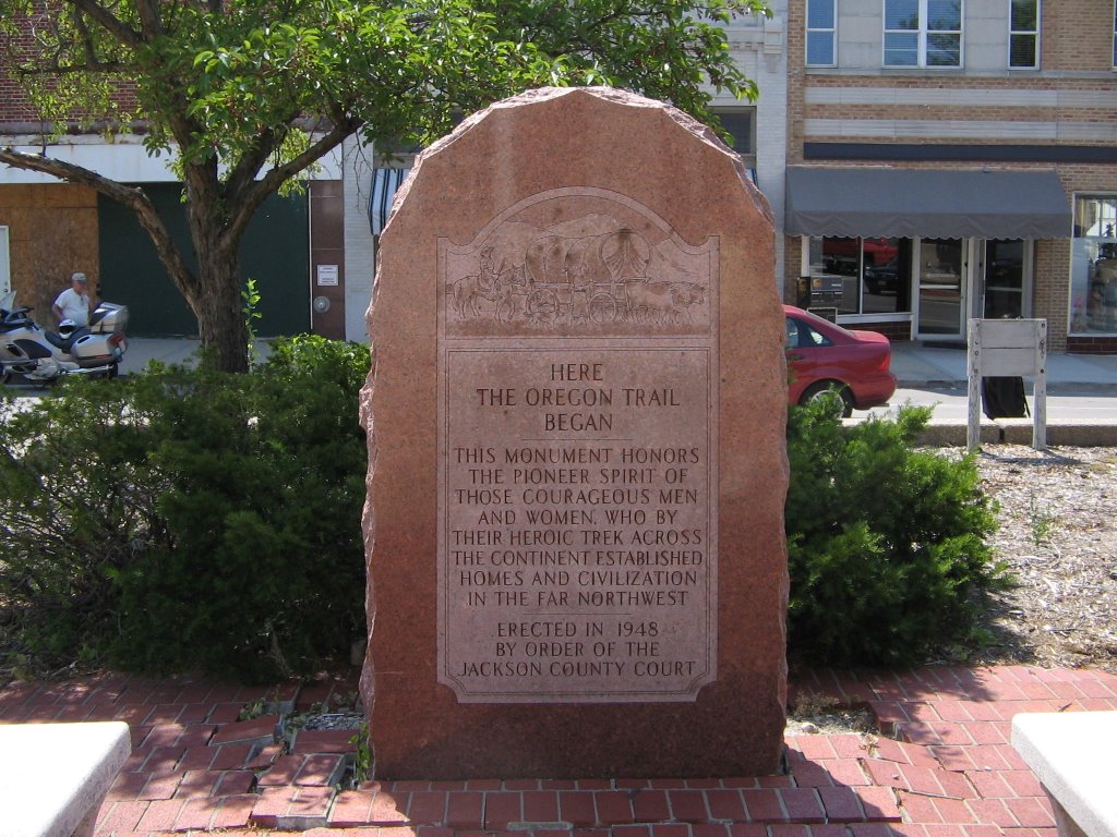
We started our journey in
The two things of interest here are
The museum is very nice. It is dedicated to the various trails of the old west. A history buff would greatly enjoy a trip there.
Saint Mary’s
Along the way in
After the mission shut down the Jesuits opened up a school and seminary. Famous students include Catholicgauze's hero Spencer Tracy. Future Vice-President Charles Curtis; part Kaw, was baptized here as a child.
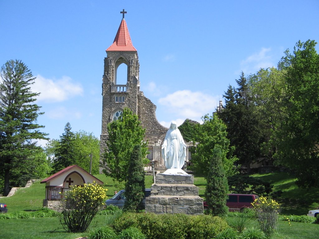
The town is in a sad state. The overwhelming Catholic majority is split between communion with
Alcove Springs
In summer the spring were the Donner Party encountered death for the first time lacks its waterfall.
Near the city of
Ash Hollow
Something bad happened near here. Really, really bad. While signs say the army went to "chastise" Indians for a massacre, a sign five miles away, almost hidden talks about how the army gained Indians trust by faking parley and then ambushing the Indians. The wild west was ugly. Atrocities and crimes committed by both sides.
Chimney Rock
Really neat. Erosion, cannon ball practice, lightening, and World War II training air raids have cut down the height however. The rock was known as the Elk's Penis by the Indians.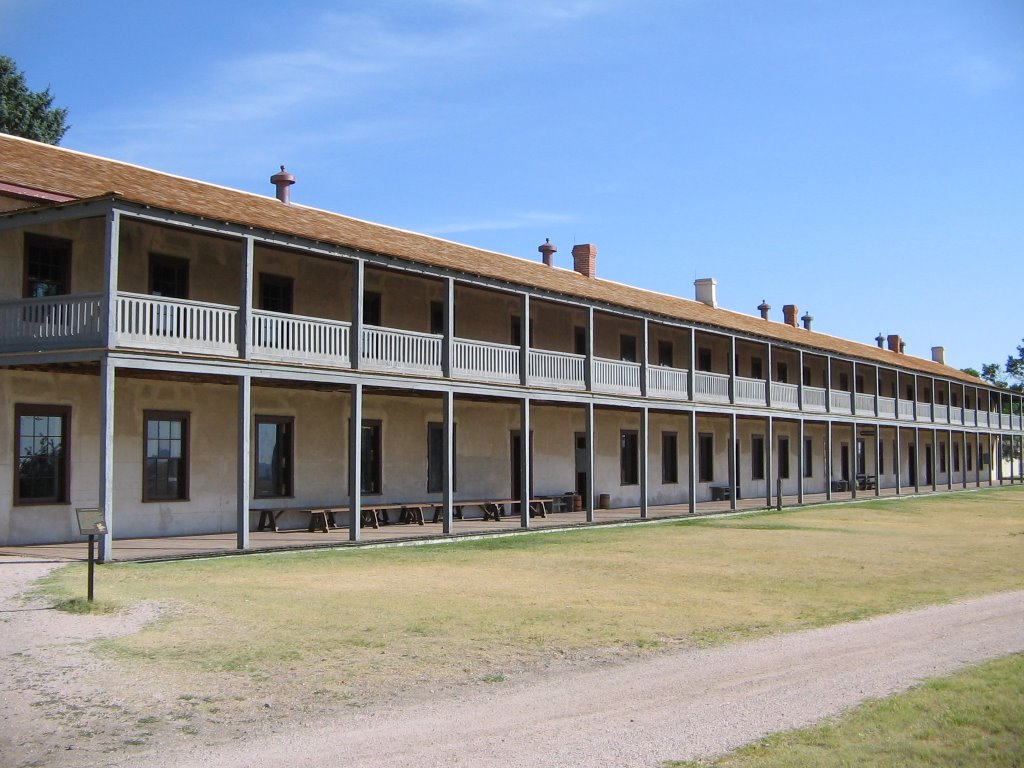
The neatest fort I have ever been too. Some of the buildings are ruins while others have been kept in ship shape. The officer quarters were prairie mansions while the enlisted men had to sleep in barracks on boarded beds.
The museum and displays unfortunately solely focus on the fort itself while ignoring its importance on the trail and in the area. I saw no markers discussing the 1868 Sioux treaty. Only general information was given about helping emigrants. A grounds keeper/tour guide however was a great source of information about the soldiers, civilians, and Indians who lived at the fort.
In the distance Laramie Peak was visible. Bluffs and hills encircled the area. The Great Plains section of the
One problem for the international traveler is currency exchange. So what happens when currency exchange and maps are combined? A very happy Catholicgauze.
Oanda, a currency website, features an interactive map which compares currency exchange rates and provides basic geographical information on each country. The map is a very useful tool for travel and research. (Hat Tip: Cartography)
Category: Maps
Happy Independence Day! On July 4, 1776 the Second Continental Congress adopted the Declaration of Independence. The colonies decided the war against the English empire, started in 1775, was irreversible and followed Patrick Henry's words of "Give me liberty or give me death!"
The Revolutionary War started in 1775, reached a climax in 1781, and finally ended 1783. Military.com has excellent maps from the West Point Atlas of the various battles of the war.
The war started on Lexington Green spread globally. French, Dutch, Spanish, and Maratha remnants waged conflicts all across the globe.
 Italy
Italy France
 Portugal
 Germany
These are the four countries that will battle it out to for the World Cup.
I know I have blogged about the World Cup before but I have a theory. Sun Bin thinks population can explain the teams that will rise or fall in the competition. But I do not think so. Globalization is the key. The list of countries in the World Cup at the start was a fair balance between the first and third worlds. However; only
So what will happen? Well my top pick of
The Germans will roll over
Category: Sports

Fellow blogger and American hero (he is in the navy so stuff it!) Eddie of Live from the FDNF was inspired to read The Next Christendom by Episcopalian Philip Jenkins.
Below are Eddie's thoughts on the book
This book fills a valuable gap that has been notable in many writings of strategists (with the exception of Ralph Peters who discussed it in detail in “Hidden Unities”): the rise of Christianity in the “Global South”, i.e. the Southern Hemisphere. Already there are far more Catholics in the non-Western world (Latin America, Philippines, Africa, increasingly China) than “Western” Catholics, and the numbers are only going to rise in the near to mid-future. The author offers a fascinating portrait of what kind of Christianity exists in the Southern Hemisphere (his conclusion is that many of the “Southern” churches are a return to the “roots” of Christianity, i.e. before the Romans “widely” sanctioned it.), what likely impact the rising Southern populations will have on the global church leaderships (Catholic, Pentecostal, etc) and policies (liberal churchgoers are in for a hell of a surprise when their campaigns to liberalize issues like gay marriage and abortion within the church come up against the even more conservative global South) and the impact of the two great surging (and often competing (in countries like Nigeria)) religions, Islam & Christianity, in the future.
Two other reviews can be found here and here. Both Eddie and I recommend the book as a well researched and written piece of religion and geopolitics.