Russia needs babies much like France and Germany. A population growth rate of almost -.5% (that's bad) is fueled by a fertility rate of 1.4% (2.1% is needed for growth), poor medical infrastructure, and bad habits like alcoholism.
Vladimir Putin knows this and his Nashi or "Ours" group is setting up giant Woodstock-style rallies/orgies to encourage young Russian to create a new generation. Best of luck to the effort.
Meanwhile Britain is also having negative growth (note: the raw number growth rate is slightly positive; however, that includes immigration which is keeping the number afloat) yet environmentalist are calling for even more limits on families. The Economist magazine is wondering if children should be considered a public good.
Hopefully these two countries can figure out something to grow and not perish.
Tuesday, July 31, 2007
Monday, July 30, 2007

Sunday, July 29, 2007
World Monuments Watch
In preparation for the upcoming landscape geography series, Catholicgauze will kick it off with a map of world monuments at risk. World Monuments Watch is an online map which locates and describes monuments at risk due to urban change, abandonment, natural risks, war, etc.
Monuments define a culture's values, history, and everything else. If a culture does not value its representations on a landscape it does not fully respect itself.
Hat tip: Geography@About.com
Monuments define a culture's values, history, and everything else. If a culture does not value its representations on a landscape it does not fully respect itself.
Hat tip: Geography@About.com
Saturday, July 28, 2007
The Future of Cartography: Dynamic, Custom, User Created Maps
I was planning on doing this article for a week. But now that I have been beaten to the punch I might as well do it now.
There are two must reads about the future and present state of cartography. CartoBlog's Dynamic Maps: The New Cartographic Medium and the New York Times' With Tools on Web, Amateurs Reshape Mapmaking.
The two articles tell of the future. Where user created content on a dynamic map base will become a big attraction and maybe even industry. For far too long people have been searching in vain for maps that fill some small niche but do not exist. Now anyone can make their own map and share it with the world with tools like Google Maps, Google Earth, Platial, etc. Need a specialized biking map of your hometown or map of Chinese restaurants? Now odds are much greater that it will be available.
Leading this revolution is a major shift in cultural thought. Information is now meant to be distributed freely and openly. This mirrors other advances in the internet like free encyclopedias and free blogs. Now longer is information viewed as power and only to be sold at a price; it is now seen as a natural right. Neogeography has changed the nature of field from a Gnostic nature to evangelical protestant one.
Friday, July 27, 2007
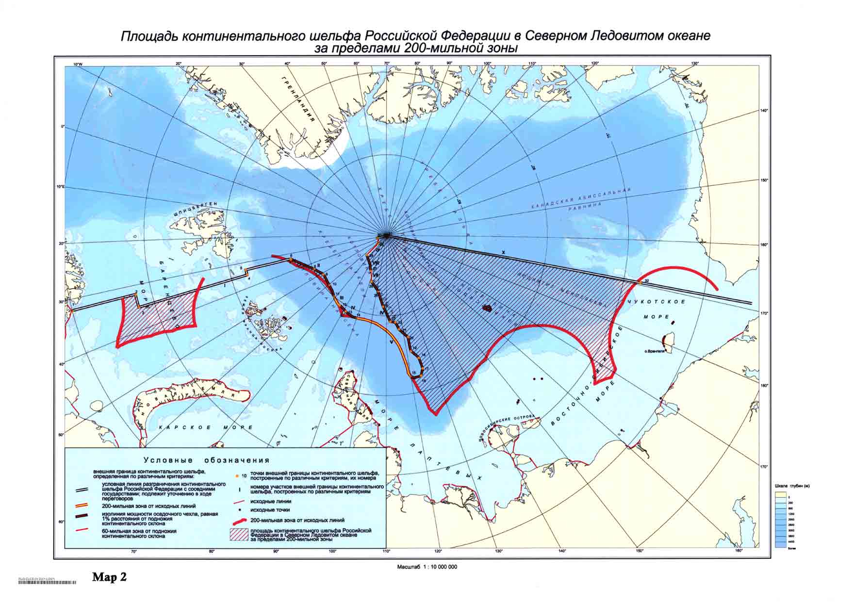
Lomonosov Ridge and the Legal Battle for the North Pole
The North Pole may one day belong to a foreign power. The Lomonosov Ridge (map) has come under dispute by Norway, Denmark, Canada, and Russia. The argument is officially over whether or not the ridge underneath the pole is actually connected to a continental shelf thus falling under complex laws of which countries can control the sea and sea floor. The real reason is the estimated ten billion barrels of oil which could be drilled if a country had legal control.
Earlier Denmark announced its desire for the pole. Russia recently released a geological study claiming the ridge was part of the Asian continental shelf and therefore Russian.
Much like Danish-Canadian fights over the Arctic, this may seem pointless but never underestimate the desire to control territory and resources. This fight may also have a major affect on international travel. Flights from the Far East to the United States take the great circle route over and near the North Pole because of the international access. An aggressive Russia may one day cut off this path thus making it much more difficult and costly to send people and material across the world.
Thursday, July 26, 2007
Virtually Traveling to Cultural Sites
CyArk allows users to explore 3D representations of famous cultural sites all over the world (requires Java). The preferred geographical way to browse models is via the map. Many of the sites are ancient while others range from Medieval to Old (American) West. The navigation is a little confusing but nothing that one cannot handle. (Hat tip: Very Spatial)
There is more of a purpose to this than merely to impress. The geographers' hope is to integrate this technology into mapping and geographical related works like archaeology. 3D rendering can be used already with Google Sketchup to add objects to Google Earth. These modeling efforts help us visualize, understand, and imagine the world better.
There is more of a purpose to this than merely to impress. The geographers' hope is to integrate this technology into mapping and geographical related works like archaeology. 3D rendering can be used already with Google Sketchup to add objects to Google Earth. These modeling efforts help us visualize, understand, and imagine the world better.
Wednesday, July 25, 2007
Earth Recycles Its Own Crust
The crust of the earth which we all live, work, and play on has been recycled, according to a new study. The earth recycles its crust as it disappears into the mantle only to be forced back out again. Scientists studying the the Azores examined isotopes and realized the crust there is around 2.5 billion years old.
Meanwhile, the 3.8 billion old piece of crust in Greenland described the Azores crust as "cute."
Meanwhile, the 3.8 billion old piece of crust in Greenland described the Azores crust as "cute."
Tuesday, July 24, 2007
Harry Potter Geography
Since those who are Harry Potter fans have finished the last book and now are back browsing the blogs, this post is for them! The Harry Potter Lexicon has an atlas containing the various places where the books take place. Enjoy! (Hat tip: Very Spatial)
Turkey's Justice and Development Party is Victorious
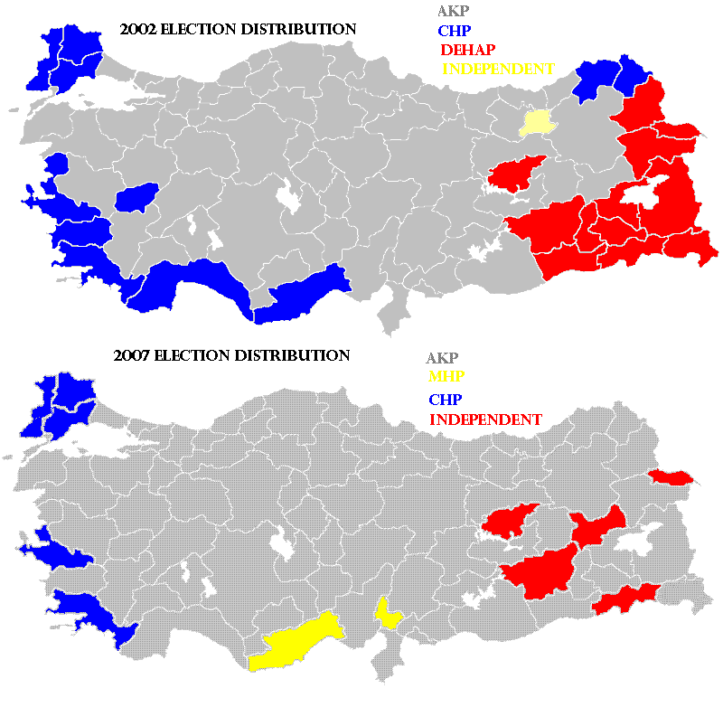
The AKP (grey) is the party of the people right now. The CHP (blue) has the backing of European-minded Turks and the army. Kurdish independents (red) have entered the political process. Map from Wikipedia.
The Justice and Development Party (AKP) is victorious in the 2007 Turkish general election. The AKP won about forty-seven percent of the vote compared to the twenty percent of the Republican People's Party (CHP). Due to Turkey's election laws the AKP and CHP have lost seats even though they received more votes than they did in 2002.
Another major winner in the election is the Nationalist Movement Party (MHP). The party earned 70 seats in central Turkey along the ethnic Turk/Kurd border. The MHP is an ultra-nationalist Turkish party. Its primary platform deals with crushing Kurdish terrorism both in Turkey and northern Iraq.
In the east Kurdish politicians have managed to pull off victories.
The main thing to be seen is who the AKP head and Prime Minister of Turkey Recep Tayyip Erdoğan nominates for the president. AKP has a Islamic agenda which starkly contrasts with modern Turkey's political tradition. Erdoğan is currently negitoating with the secular CHP in an attempt to avoid gridlock. The primary thing Eroğan is trying to avoid though is a coup. The Turkish army considers itself the guardians of Turkey and has not been afraid in the past to overthrow (or "advise") the government in order to protect Turkey's secular republic.
With gainning more votes equaling losing seats and army's protecting democracy you might think you heard all the craziness of Turkish politics. But there is more! The AKP is the most openly Islamic mainstream party in Turkey yet it promises to keep good relations with Israel and the United States. The AKP is also actively seeking membership in the European Union (the EU on the other hand is tepid to allow an openly Islamic government into the post-Christian organization).
The CHP also has had good relations with Israel and the United States. This may seem surprising because the CHP is a member of Socialist International and considers itself a revolutionary party. Leftists in Turkey however are quick to point out the CHP is now the party of the army and the status quo.
For previous works on Turkey click here.
Monday, July 23, 2007
Gas Prices Around the World: June 2007

Gas prices must be going up again. Caracas, Venezuela's prices have jumped a full three cents in the last year.
The map above is from Wired the online magazine. Before you get to angry at the price in the United States just be grateful you do not own a Hummer in London. And before you become jealous at Iran's prices just remember you never had to put up with gas riots.
The price of gas in the world is right now dictated by two things: subsides and environmental regulations. Many of the oil producing companies can afford (or in Iran's case pretend to afford) to artifically keep their gas prices low. Western countries have heavy taxes and environmental regulations on referining oil into gasoline. This naturally raises the price of fuel.
Sunday, July 22, 2007
La Paz versus Sucre

The geopolitics of Bolivia can be summed up as La Paz versus Sucre and Santa Cruz. (Map from CIA World Factbook)
Hundreds of thousands of Bolivians rallied in La Paz against a proposed measure which would make Sucre the sole capital of Bolivia. Currently, La Paz is the where the president and National Congress hold office while Sucre is the capital in the constitution and seat of the Supreme Court.
The capitals have deep cultural and geographical meanings. Sucre was the former sole capital of Bolivia. During the time of New Spain it was named Ciudad de la Plata de la Nueva Toledo or La Plata for short basically meaning "Silver Town." During the late 1800s; however, the economy shifted from silver mining in eastern and central Bolivia to tin minning in the west. La Paz was the urban center for silver mining by then and in 1898 most of the government moved to the city.
The cultures of the two cities are different. La Paz and the western part of the country are in the highlands, poor, and have a large Indian population. Sucre, the central, and eastern parts of Bolivia range from moderately high up to lowlands, economically better off, have a larger population of mixed blooded and whites, and most importantly tend to vote center-right. La Paz is the center of leftist thought while Sucre is the center for the Catholic Church. Night and day.
Conservative elements have introduced the measure to move the capital back saying Sucre's central location would help unify a divided country. Opponents claim it is merely a measure to kill the proposed changes to the constitution including granting leftist President Evo Morales Hugo Chavez-like powers.
The latest battle between La Paz and Sucre is political, cultural, and geographical. It is not the first battle between regions in Bolivia and it will not be the last.
Saturday, July 21, 2007
Culture Smart Cards
The military is realizing the importance of cultural geography. Culture Smart Cards are being handed out to marines. The cards contain useful cultural information about countries. Language, religion, ethnic groups, behavior and more.
The Iraqi culture card is fascinating. Did you know the red Islamic flag means sacrifice? That a red-checkered male headdress means the wearer did the Hajj and comes from a monarchy? That the "OK" hand signal is obscene to Iraqis? And that no one likes the Turkoman besides the Eastern Rite Catholics? All this and more on the card is very useful to the average grunt on the ground.
Sadly most of these cards are off-limits to civilian purchases. I wish one day they will be released because my former students would have benefited greatly from this easy-to-use yet in-depth source.
Friday, July 20, 2007
Geography Blog Stereotypes
New reader PPO and I discussed the various geography blogs on the internet. PPO managed to create the following stereotypes for entries on the blogs. I think they are all in good fun.
Geographic Travels with Catholicgauze! "Online Map of the Geopolitics of the Overlooked along the Oregon Trail who are Oppressed by Terrorists."
Geography@About.com Completely normal short post which sends everyone over the deep end. (Catholicgauze Comments: Case in point Northern Cyprus)
The Map Room "Family Raped, Murdered by GPS Navigation Unit"
Strange Maps "Another Unique Map for My Million-Bijillon Readers"
Very Spatial "Podcast of Our Roadtrip to the Second Life Universe"
Thursday, July 19, 2007
Popular Culture versus Fake Culture: Cerne Abbas Giant versus Homer Simpson
Update: OLIVER Cromwell... sorry Brits.
Radical Geography has pointed out Homer Simpson is the Cerne Abbas giant new neighbor. The giant Homer icon on the landscape has upset local neo-pagans; however. They claim Homer is disrespectful to their fertility god-thingy.
There is a problem with their argument. The giant is not some pagan symbol but instead probably a parody of Oliver Cromwell dating from the time of the English Civil War.
This does not stop neo-pagans from making up their own history. The Long Man of Wilmington is another cultural landscape adopted into the fake pagan landscape (a "fakescape" if you will). Stonehenge, built before the time of the Druids, is now a popular neo-pagan landmark where people who style themselves druids come to worship.
Catholicgauze is curious what future archaeologist will think thousands of years from now when the trace remains of the Cerne Abbas giant. Maybe, somehow, they will find a picture of Homer by the giant and wonder who these gods were.
Tuesday, July 17, 2007
NGA Gazetteer
Before the new version is officially and fully released, be sure to check out what you are not going to miss. The National Geospatial Intelligence Agency's Gazetteer allows one to find locations around the world and display it in a variety of map scales. User friendly it is not.
Potsdam Conference's Geography of Betrayal
More than fifty million people died in World War II keeping the world free from evil, oppressive governments. So what did the British and Americans do at the end of the war? They gave half of Europe to an evil, oppressive government.
On July 17, 1945 the three victorious powers of the European theater of the war gathered in Potsdam, Germany to discuss the future. The free governments of the United Kingdom and the United States were weakened before the meeting though. America had lost President Roosevelt (who while in a weakened condition gave concessions to the Soviet Union with guidance from Soviet agent Alger Hiss) and Great Britain had voted Winston Churchill's Conservative Party out of office in favor for an appeasing Labour government.
At the meeting several key geographical changes were made. They included:
Along with the first point was the abandonment of Eastern Europe to Communism. The Polish Government, in exile since the start of the war, was ignored and the Soviets installed their own puppet government. The Russians also refused to acknowledge Potsdam's call for one Germany and started the German Democratic Republic (East Germany). Eastern Europe fell under Communism's grasp and it would not be until the 1990s liberation would come.
Potsdam plays a major role in historical geopolitics. The whole Cold War from the Berlin Airlift, to the Hungarian uprising, to the downfall of Yugoslavia all were made possible because of the concessions made at Yalta and Potsdam. The effects are still felt today. Eastern Europe is playing catch-up economically with Western Europe. The Eastern European nations are also more wary of Western European political leaders. Eastern European nations also split with Western Europe in the New versus Old Europe debate.
So on the sixty-second anniversary of the beginning of Potsdam, let us all remember that short term solution can cause long term problems. But more importantly, let us leave no world citizen behind.
On July 17, 1945 the three victorious powers of the European theater of the war gathered in Potsdam, Germany to discuss the future. The free governments of the United Kingdom and the United States were weakened before the meeting though. America had lost President Roosevelt (who while in a weakened condition gave concessions to the Soviet Union with guidance from Soviet agent Alger Hiss) and Great Britain had voted Winston Churchill's Conservative Party out of office in favor for an appeasing Labour government.
At the meeting several key geographical changes were made. They included:
- Dividing Germany and Austria into four zones of control.
- Moving the German-Polish border west to the Oder-Neisse line (which was not recognized by West Germany until reunification with the East)
- Transfer of Koenigsberg to the Union of Soviet Socialist Republics as part of Russia
- The ethnic cleansing of German colonialists and ethnic Germans from Poland, Czechoslovakia, and elsewhere in Eastern Europe (up to 500,000 Germans were kicked out of the Sudetenland alone)
Along with the first point was the abandonment of Eastern Europe to Communism. The Polish Government, in exile since the start of the war, was ignored and the Soviets installed their own puppet government. The Russians also refused to acknowledge Potsdam's call for one Germany and started the German Democratic Republic (East Germany). Eastern Europe fell under Communism's grasp and it would not be until the 1990s liberation would come.
Potsdam plays a major role in historical geopolitics. The whole Cold War from the Berlin Airlift, to the Hungarian uprising, to the downfall of Yugoslavia all were made possible because of the concessions made at Yalta and Potsdam. The effects are still felt today. Eastern Europe is playing catch-up economically with Western Europe. The Eastern European nations are also more wary of Western European political leaders. Eastern European nations also split with Western Europe in the New versus Old Europe debate.
So on the sixty-second anniversary of the beginning of Potsdam, let us all remember that short term solution can cause long term problems. But more importantly, let us leave no world citizen behind.
Map of the tragedy which is twentieth-century European geopolitics
Monday, July 16, 2007
The Holocaust of Women
Six million Jews and five million other "undesirables" were murdered by Nazi Germany during the Holocaust. The world realized too late the horror of what was going on and even today tries to learn from what occurred and vowes "Never Again."
Unfortunately today genocides and other killings continue with very little action. One of the bloodiest actions is a rarely reported war against women. A recent study by the United Nations population fund states sixty million (60,000,000) females are "missing" from Asia. Abortion is the number one killer where pre-birth sex screenings give people like the Chinese and Indians the oppurtunity to prepare an abortion against "worthless" girls who bring nothing to a traditional family. India especially has problems with the dowry system. The system makes have girls a financial and cultural burden on a family. Up to half a million girls "disappear" each year in India.
The trends are frightening. In some areas of China there are 130 men for every 100 women. This leaves twenty-five to thirty million men in China without a bride creating a formula for violence. The sex-slave trade of women has also increased. Hindu girls from neighboring countries are being smuggled into India to serve as brides for men who cannot find local women to marry.
This holocaust is truly global in its reach. The Balkan countries in Middle American Hispano nations are seeing an increase in the use of abortion against girls. The trend is even reaching America where traditional emigrant families from China, India, and elsewhere still see girls as more of a burden and use America's liberalized abortion laws to "take care of the problem."
Sunday, July 15, 2007
A Chinese Army to Control the Weather
Thirty-two thousand people are employed by the People's Republic of China in their weather control program. The operation costs up to ninety-million dollars and members are equipped with everything ranging from rocket launchers to modified anti-aircraft guns.
The small army influences the weather for more reasons than just to alleviate drought. Everything from firefighting to having the perfect conditions for the Olympics are now being influenced by Chinese efforts.
An interesting question for the future is concerns the "right" of countries to make it rain. The moisture that is being prematurely forced into rain could have become rain for South Korea, Japan, Taiwan, etc. A whole slew of problems from water access to denying rain for political purposes to others are just some potential things which may lie in the future.
Saturday, July 14, 2007
Catholicgauze: Now a Professional Geographer
Catholicgauze is beginning a new chapter in his life. I am now a professional geographer. So add this to finishing my thesis and I am one very busy geographer.
Rise of Man Across the Globe
Journey of Mankind is a time-lapsed map which shows the spread of mankind across the earth.
The map shows triumph and tragedy's our race has faced. The start in Africa, the failed colonization efforts by the "Cain" branch followed by "Seth" or "Adam." The Indian Ocean coast was the main path of migration until the Mt Toba eruption nearly killed off humanity. Southeast Asia then became the new starting point for the third wave of human migration.
The map also has additional information for each stage. Note how the cycles of global warming and cooling impacted the spread and decline of humans from locations.
The proto-Catholicgauzes sure were a traveling group. It is a wonder that they managed to survive and thrive while others perished.
(Hat tip: Infonaut)
Friday, July 13, 2007
Iraq War Maps - July 12
As the Iraq War continues to dominate headlines a recent press release (PDF) contains some very good maps.


A Map of captured al Qaeda. Note how the activity centers on the greater Baghdad area and Mosul. Both these places are fringe areas for the Sunnis.

A Map of al Qaeda activity. The map is made by al Qaeda. Note how the map calls Shia "Rejectionists" and is equally against "Turks" meaning Kurds. The Arab al Qaeda has accepted the Western ideal of racism. Traditionally Islam has been a unifying religion but recent radicalism has introduced racial bigotry. The bigotry is spreading elsewhere including Sudan where Arabist Muslims are killing black Africanist Muslims.

Finally a map of Iraqi controlled areas of Iraq. Progress is slow but continuing. The southern areas, most peaceful with the exception of gang and some Mahdi army, is quiet. The Kurdish zones have also been relatively easy. The problem is in the Sunni areas of Baghdad and elsewhere.
(Hat tip: Gateway Pundit)
Thursday, July 12, 2007
Greenland Really Green 450,000 Years Ago
A new DNA study shows Greenland was really green 450,000 years ago (Greenland got its name because of some green areas right before the Little Ice Age). The study shows just how volatile the earth's climates are. Also, DNA trends hint that Greenland's ice is more resistant to melting than previously though.
Wednesday, July 11, 2007
Fantasy Atlas
The Map Room has linked to Fantasy Atlas. The online atlas is a collection of maps of science fiction and fantasy stories. Its in German but fortunately the maps are broken down by author. With Catholicgauze drowning right now in work I wish I could escape to one of these lands right about now.
Tuesday, July 10, 2007
Court forbids Patriarch's Title
There is a joke Catholicgauze was once told that goes like this:
Q: Why don't Protestants ever claim the Patriarch of Constantinople is the Antichrist even though Catholics and Orthodox share many of the same beliefs?
A: Because the Antichrist has better things to do than listen to the Sultan for 500 years.
The joke refers to how the Orthodox Church (sans Russia) fell under the control of Ottoman Muslims starting with Sultan Memhemd II appointing Gennadios II Scholarios. For centuries the Greek Church was overseen by Muslim rulers.
Today the patriarchs are elected by fellow Orthodox but the Turks still have control. The Patriarch must be a Turkish citizen (due to Turkish law) and a court ruling forbids the Patriarch from using the title "Ecumenical Patriarch" (The Eastern Orthodox Churches recognize the Patriarch as a first among equals). While the Patriarch is trying to reverse the ruling, he seems to be accepting it. How things change how things stay the same.
Monday, July 09, 2007
The Inner Workings of Google Earth
There are three overarching fields of geography. They are human, physical, and technical. Technical is the newest field of geography and has found applications not only in the academic and public sectors but also in the private sector. The private sector's application of choice is GIS and the company which has dominated the field was ESRI.
There is a change going on in technical field. Google Earth is quickly becoming a key player in technical geography circles. Much more than a way to see your house, Google Earth allows users to import data and see spatial information displayed on the earth. With upgrades one can even import GIS data. The thing which differs Google Earth from the rest of the field; however, is its ease of use and accessibility.
Two good articles on the inner workings of Google Earth are out. The first one, How Google Earth [Really] Works, discusses the computer science behind Google Earth. The second article, Google’s Geospatial Organizing Principle (PDF), goes into the philosophy which motivates Google. (Hat tip: Google Earth Blog [1][2])
Even though Catholicgauze has had its qualms with Google and its practices with China, I still wish it success in the world of neogeography. More and more people will be involved with technical geography, many without knowing it, as the technology advances. May Google Earth be a tool to truly educate the people about the geography of the world.
Sunday, July 08, 2007
Murals of Northern Ireland
Video of Murals in Northern Ireland
The walls of Northern Ireland enrich the landscape with meaning. Many sides of buildings to separation barriers known as Peace Lines are home to murals conveying Republican and Loyalist messages.
Murals became popular in the 1960s. One of the first and most famous murals served as a border marker for IRA occupied "Free Derry" neighborhood of Londonderry. Others made their own murals to show neighborhood allegiance and to convey political messages.
There has been a recent change in Northern Ireland's murals. As the peace process continues some murals have been painted over with non-partisan unifying murals depicting works of literature or soccer players.
The murals of Northern Ireland prove once again that reading the landscape is an exactly way to understand cultures.
From more murals (thanks Wikipedia!):
Republican Murals
More Republican Murals
Loyalist Murals
More Loyalist Murals
BBC Gallery of Murals
Baseball and Blue-Collar America
GTWC! reader and geographer of Americana Deaner has started his own blog entitled Blue-Collar Baseball.
The blog is an insider's view to Blue-Collar culture and its values as lived via baseball. The simple things like friendliness, being humble, and the lack of large sums of money sums up the things Blue-Collar Baseball aims for.
Be sure to note that the range of teams covered by the blog expand from Missouri to Michigan to western Pennsylvania. A sort of interior belt not quite Midwest but instead a region mixing the Midwest with Appalachian-Southern values.
Saturday, July 07, 2007
A Frozen Tidal Wave of a Metling Glacier
Since Catholicgauze is dead tired so I will make this short. The photo essay of a melting glacier is stunning. While the photo essay is perfectly safe for work the rest of the site is hit and miss on safe for work.
Friday, July 06, 2007
Zimbabwe: Invade Us, Please!
Zimbabwe is another tragic post-colonial African story. A peaceful transfer from British to African control was accomplished with Robert Mugabe guiding the country to a fairly bright future. Somewhere along the lines things took a turn for the horrible, however. Mugabe went from semi-moderate to radical. White farmers had property stolen from them, famine occurred due to mismanagement, homosexuals brutally attacked by government forces, and now inflation is somewhere around 15,000% a year (41% a day compared to 2.5% a year in the United States). Add onto the tragedy a HIV/AIDS infection rate of 24.6% and an average life expectency of under forty years.
Things are so bad in Zimbabwe that the Catholic Archbishop of Bulawayo, Pius Ncube, is calling for the United Kingdom to liberate the country by force. This from a man who is noted for his human rights and non-violence record.
Ncube knows the British colonial system made Zimbabwe. More importantly he knows the British left Zimbabwe washing their hands like Pilot. He is praying Britain realizes responsibility and gives Zimbabwe another chance.
Note: Another sad thing on Zimbabwe is how the other African countries treat it. South Africans Nelson Mandela and President Thabo Mbeki turn a blind eye to it. They realize the damage being done but are so anti-European they oppose intervention.
Thursday, July 05, 2007
Map of the Cultural Revolution

Praising Mao and his glorious anti-capitalist revolution. From Catholicgauze's personal map library. Gift from Lady of TDAXP.
In 1958 Mao Zedong started the Great Leap Forward. The GLF was intended to advance agricultural China to an industrial nation with a new culture. Two years and up to forty million dead later the GLF was ended.
The disaster hurt Mao greatly. Many in the Communist Party of China wanted him out. So Mao came up with a new plan. The Cultural Revolution was Mao's war on the party. Anti-Mao members were killed and local parities were reconstructed. The party became even more of a personality cult.
The first province to be purged was Heilongjiang in the very northeast of China. The bulk of the southeastern province experienced the revolution in early 1968. Xinjiang and Tibet in the far west of China were the last two provinces. There time came in early September of 1968.
Culture was once again attacked. Churches, temples, and schools were destroyed. Anything which would interfere with Mao becoming a secular god-king was viewed as old and needing to be destroyed.
The revolution ended along with Mao's life in 1976. It would take Deng Xiaoping to institute his own revolutionary ideals to make China into the power that it is today.
Wednesday, July 04, 2007
Declaration of Independence and its Legacy
Catholicgauze wishes everyone a happy Fourth of July! The Declaration of Independence was adopted 231 years ago today. Be sure to read it!
The ideals of people have the right to "Life, Liberty and the pursuit of Happiness" and "Governments are instituted among Men, deriving their just powers from the consent of the governed" have had massive impact on the world.
Domestically these statements led to the creation of a republican government on federal, state, and local level. The ideals feed into the abolition movement, the Civil War, and the liberation of the slaves. They continued on into the twentieth century with the Civil Rights movement. They are alive today in a wide range of issues ranging from abortion, immigration, and civil liberties. Elections are won and lost on these issues and the elected leaders change the course of history.
The American Revolution inspired the French Revolution. The downfall of the Ancien Regime in turn planted the seeds of republican revolution which would sweep across Europe and begin the end of classical Europe.
Even those who opposed the American Revolution were inspired by the ideals which were its foundation. Loyalists who fled after the war settled throughout the British Empire. These people brought with them theories on local governance while still being proud British citizens. Many settled in Canada where they became active in the political scene. Canada later became the first British colony to be granted limited self-rule in part due to the Loyalists' ideals. Canada proved to be a template for other colonies to gain independence from the United Kingdom.
Happy Independence Day and Happy Birthday Mom!
Tuesday, July 03, 2007
The Overlooked: Samaritans

The story of the Good Samaritan is what most people think of when they hear the word "Samaritan." The story was revolutionary at the time because a Samaritan, the outsider of the outsiders, was the only one to offer help to the wounded Jew. Today many people do not know what a Samaritan is or that Samaritans continue to live today.
Location
There are only about 705 Samaritans left. About half of them on the outskirts of Nablus and the other half lives in Holon near Tel Aviv.
Culture and Religion
Samaritans share the same lineage as Jews. However, they claim to be the true keepers of the faith and culture of the ancient Israelites. Their religion, Samaritanism, is based on the written Torah (Genesis to Deuteronomy) but with a different version of the ten commandments. The last commandment is expanded to include God declaring Mount Gerizim the holy spot of Israel. It is this commandment which gives Samaritans religious justification to its construction of their holy temple on Gerizim. Samaritans believe Moses was the last prophet (the other prophets of the Old Testments are fictional according to the Samaritans). Another difference to present-day Judaism include the Samaritans continued use of a priesthood and denial of the Talmud and any rabbinical law.
History
It is known that Samaritans came from the northern tribes of ancient Israel. No one knows exactly when Samaritans and Jews separated from each other. It was once believed the Samaritans intermixed with invading pagan groups but this theory has fallen out of favor. Whatever the reason, by the end of the fourth century BC the split was finalized. The Jews had their temple in Jerusalem while the Samaritans had their's forty miles away on Mount Gerizim.
During Greek occupation the Samaritans were relatively well off. However, while external persecution was light some Samaritans embraced Greek culture. Things changed when the Maccabeean John Hyrcanus conquered Samaritan lands and destroyed their temple.
The Roman era was a mixed time for the Samaritans. The Samaritans were not granted the same special exception of religious freedom that the Jews received. The Samaritans were forced to offer sacrifices to the Roman imperial cult. The local Jewish leaders kept up persecution on Samaritans who became virtual untouchables. After the failed Jewish revolts against Rome, things changed somewhat. Samaritans were allowed to rebuild their temple. The Samaritan leadership made the effort to constantly remind the Roman authorities that Samaritans were not like the "troublesome" Jews.
The Christian empire was no friend of the Samaritans. Religious oppression led to failed revolts against Emperor Zeno and Justinian I. The temple was destroyed again. Justinian I allied with the Christian Ghassanid Arabs to crush the last Samaritan revolt. Tens of thousands of Samaritans were killed or forcibly converted. It was a blow that the Samaritans would never recover from.
The Islamic Era was one of attrition. Samaritans were granted People of the Book (Dhimmi) status. Many of the remaining Samaritans converted over time to end the economical and social oppression against them.
Today
Despite their history and being in a geopolitical powder cake Samaritans have managed to reach an equilibrium. They keep their faith while sending the children to either Israeli or Palestinian schools for secular education. The close knit group official remains neutral on the complex political issues that everyone else has strong opinions on.
The religious ceremonies held by the Samaritans are now open to religious tourists. Tourism has brought in money which the Samaritans have used to improve themselves. There is no current effort to rebuild the temple but all temple functions including sacrifice continues. The videos below documents the Samaritans' Passover celebration near Nablus.
With such a small community there are fears of interbreeding. So men are allowed to marry someone outside the faith as long as they convert. Recently the Samaritans contracted with a Ukrainian agency to find brides for two members.
There is no one external threat to the Samaritans currently. However; by being such a small group in such a dangerous area, any disaster could destroy the Samaritans chance for a future.
Additional Resources
Wikipedia Article on Samaritans
The Samaritan News - Defunct newsletter on Samaritans
The Samaritans - Everything you ever wanted to know about the Samaritans... ever
The Samaritans' Newsletter - Updates on the Samaritans
Monday, July 02, 2007
Independence Knocking on Kosovo's Door
Kosovo is currently a Serbian province under the jurisdiction of the United Nations and protection of NATO forces. While everyone agrees on what the current status of Kosovo is, no one can agree on what Kosovo's future will hold.
The United Nations plan for Kosovo's independence has been a long time coming. There is one thing standing in the way of a future ethnic Albanian state: Slavs. The Slavish Serbs in Kosovo deeply oppose separation from Serbia. They fear that a free Kosovo would join Albania The Serbs point to the fact that the current Kosovar military and local government uses the Albanian flag and Albanian national anthem. The international community is trying to make the ethnic Serbs feel included but little is likely to result from the effort.
The greater Slavic opposition comes from the "big brother" of the Serbs: Russia. Russia deeply opposes anything that would damage the Slavish image. Russia has threatened to veto any United Nations resolution granting Kosovo its independence. Stratfor recently published an article on how there are fears Russia would repeat itself by sending troops into Kosovo to stop independence. This action could potentially cause a rebirth of the Kosovo Liberation Army (whose "former" members now are in the Kosovo Protection League). If this happends expect Chechnya in Europe.
The situation in Kosovo is not clear cut. On the one side you have the ethnic Serbs whose government engaged in ethnic cleansing and picked the wrong side in the geopolitical arena. The ethnic Albanians on the other hand engaged in terrorism, formed alliances with Muslim terrorist groups, and after the Kosovo war launched an attack on Serbia.
For now the status of Kosovo is in the war, an internet war with YouTube videos battling it out continues, and a world awaits. The "international community" backs independence, Moscow's neo-satellites oppose, and Kosovo is the pawn.
Sunday, July 01, 2007
The Holocaust of Women
Six million Jews and five million other "undesirables" were murdered by Nazi Germany during the Holocaust. The world realized too late the horror of what was going on and even today tries to learn from what occurred and vowes "Never Again."
Unfortunately today genocides and other killings continue with very little action. One of the bloodiest actions is a rarely reported war against women. A recent study by the United Nations population fund states sixty million (60,000,000) females are "missing" from Asia. Abortion is the number one killer where pre-birth sex screenings give people like the Chinese and Indians the oppurtunity to prepare an abortion against "worthless" girls who bring nothing to a traditional family. India especially has problems with the dowry system. The system makes have girls a financial and cultural burden on a family. Up to half a million girls "disappear" each year in India.
The trends are frightening. In some areas of China there are 130 men for every 100 women. This leaves twenty-five to thirty million men in China without a bride creating a formula for violence. The sex-slave trade of women has also increased. Hindu girls from neighboring countries are being smuggled into India to serve as brides for men who cannot find local women to marry.
This holocaust is truly global in its reach. The Balkan countries in Middle American Hispano nations are seeing an increase in the use of abortion against girls. The trend is even reaching America where traditional emigrant families from China, India, and elsewhere still see girls as more of a burden and use America's liberalized abortion laws to "take care of the problem."
Unfortunately today genocides and other killings continue with very little action. One of the bloodiest actions is a rarely reported war against women. A recent study by the United Nations population fund states sixty million (60,000,000) females are "missing" from Asia. Abortion is the number one killer where pre-birth sex screenings give people like the Chinese and Indians the oppurtunity to prepare an abortion against "worthless" girls who bring nothing to a traditional family. India especially has problems with the dowry system. The system makes have girls a financial and cultural burden on a family. Up to half a million girls "disappear" each year in India.
The trends are frightening. In some areas of China there are 130 men for every 100 women. This leaves twenty-five to thirty million men in China without a bride creating a formula for violence. The sex-slave trade of women has also increased. Hindu girls from neighboring countries are being smuggled into India to serve as brides for men who cannot find local women to marry.
This holocaust is truly global in its reach. The Balkan countries in Middle American Hispano nations are seeing an increase in the use of abortion against girls. The trend is even reaching America where traditional emigrant families from China, India, and elsewhere still see girls as more of a burden and use America's liberalized abortion laws to "take care of the problem."
Representations of Indians and US Army along the Oregon Trail: Western Nebraska to Fort Laramie
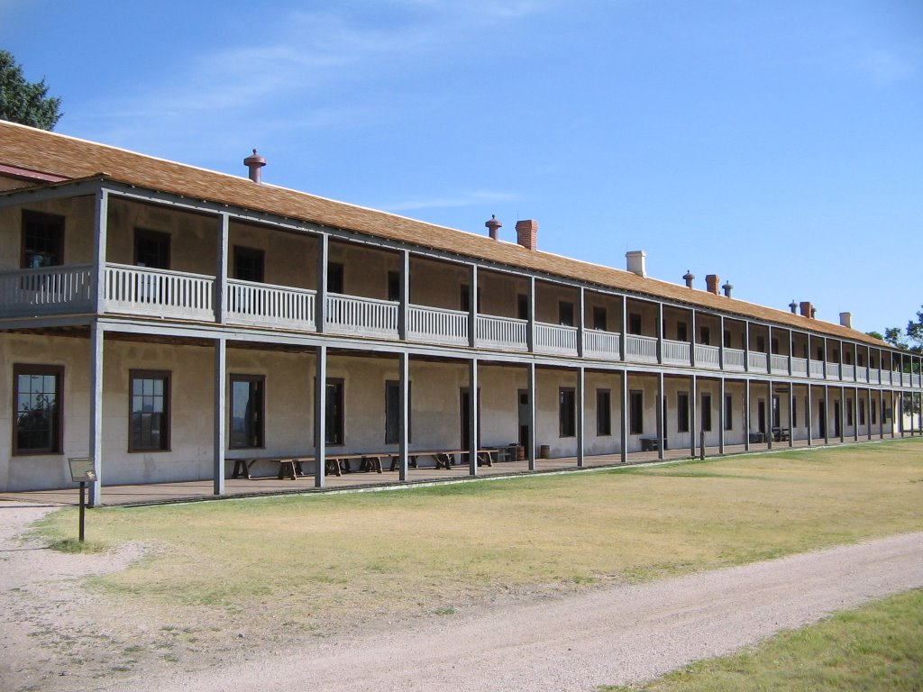
Continuing on past Ash Hollow one drives by Chimney Rock and Scotts Bluff. Here there are museums dedicated to the
In
The last stop in the Great Plains section of the Oregon Trail is
The history of
Indian and emigrant relations were good for the most part during the time frame of the
Unfortunately a great tragedy occurred in
Just as the historical archives record more tragedy then positives, so does the landscape. The Grattan Massacre site is marked by the
“No One is Home” monuments are also common. The majority of signs at the fort are dedicated to the army. Some places have markers discussing the overland trails. Other monuments are dedicated to army wives and teamsters. One information sign, Fort Laramie and the Western Movement, prides
Thus ends the study area of the Great Plains of the Oregon Trail. It was a long journey and one Catholicgauze is glad to have done.
Subscribe to:
Posts (Atom)