These two links are to videos of Blackwater personel fighting off two attacks by al-Sadr's Mahdi army who were trying to seize a US compound. The ratio was about 100:1 in favor of the Mahdis. Blackwater won.
Sniper Battle
Mahdi Rush
Category: War on Terrorism
Tuesday, January 31, 2006
Monday, January 30, 2006
Y'all tock funny, ya hear?
Does thou speaketh in Victorian tongue, doo ya speak like a New Yoorker, or do ya tock funny? A neat online quiz asks you how you pronounce certain words or what word you use for some object and tells you what
Category: Languages
Saturday, January 28, 2006
Glaciers Photos and more
The NSIDC has a neat section of glaciers and other icescapes here. What is really interesting is the gallery of glaciers from all the back to the early 1900s.
Category: Physical Geography
Category: Physical Geography
Thursday, January 26, 2006
Green Territories
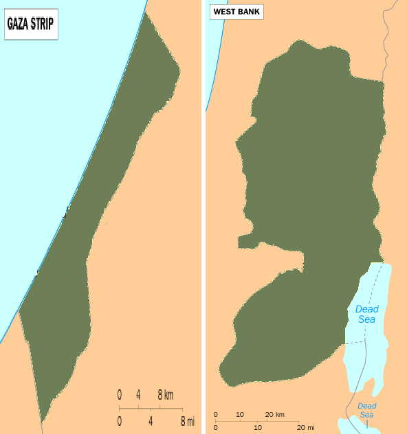
This is bad. Hamas has won most of the district level campaigns in the Palestinian election. The world woke-up to this shock after the previous night had reports of a slight Fatah victory. Currently Hamas is grabbing everything they can in celebration while pockets of Fatah fight in the street.
Why is this bad? Because it extends a series of set backs for peace (or at least progress) in the Middle East. First Sharon has a coma then a terrorist group seizes control of a failed state. It was going to be different... Sharon was making great speed at making permanent borders while the Palestinian government stood by watching unable to help or interfere. Now it seems like a Likudite like Netanyahu will most likely stop the withdrawal from indefensible regions and a hostile Palestinian government will be there snipping along with terrorist attacks.
In the game of global chess the black team has a new pawn. One hopes corruption and inefficient government will bring Hamas down. One also hopes for time.
Wednesday, January 25, 2006
Worshiping Mammon
And the Devil had a smile
and the Devil had a smile
-Lyrics to a forgotten song
Google has but profits over principal to a point they have foresaken holiness. Their so called liberal policies are damnable with their latest decisions. "What has angered this geographer?" you ask. My answer is this: 100,000,000 internet users will be denied access to freedom because Google wishes to be in bed with the bloodiest regime remaining on this earth. Google has called their decision "right" but say that to the 1.3 or so billion Chinese who suffer while Google signs a deal with communists in order so they may both worship Mammon. See the misbegotten abominattion here.
Opium
Note: Internet is back up but I have work to do so this entry shall be short.
The Opium trade is big in central Asia. The Geopium project is a half-French half-English website which offers maps and information galoure on the opium trade. The default language is Fromage but links are avilable for English translations. Here is a quick link to the map page and probably one of the more interesting maps: opium traffic map of Europe.
Category: Maps Atlases
Tuesday, January 24, 2006
The Right Marches On...
The Conservative Party has won in Canada and Stephen Harper is to be the new Prime Minister. The Conservative Party itself is formed by a not so equal merger of the dominant Canadian Alliance and the limp Progressive Conservative Party. The election results as of this morning look something like this:
Conservatives: 124
Liberals: 103
Bloc Quebecois: 53
New Democrats: 29
Greens: 0
Independent: 1
The Conservatives are the only party right of center. The Liberals tend to be center-left but mostly are an establishment party; New Democrats have socialists roots and ties; the Bloc Quebecois spilt from the old Progressive Conservative Party but presently have left-ward tendencies; and the Greens are a new party and clearly socialist.
The results in Canada show a trend internationally from the year 2000 onward. In most areas neo-liberal and conservative parties are winning elections. A brief scorecard of results follows:
Neo-Liberal/Conservative Victories:
USA- Bush twice
UK- Blair (“Neo-conservative” foreign policy and free markets puts him here)
Australia- Howard
Portugal- Cavaco
Poland- Kacyznski (Conservative Catholics defeat Neo-Liberals; left of center ruling party shut out of second round)
Ukraine- Yushchenko (Pro-West defeats loyal to Moscow Russian-Ukrainian front)
Germany- Merkel (Weak campaigning nearly lost this won but the Right pulls through)
Lebanon- Hariri (Pro-West parties defeat Syrian plants)
Japan- Koizumi
Canada- Harper
Leftist Victories:
Spain- Zapatero (Terrorist attacks throws everything in a wash and people desire peace over security)
Venezuela- Chavez survives recall (Fixed *Cough* Fixed)
Bolivia- Morales
Chile- Bachelet
Category: Geopolitics
Monday, January 23, 2006
Orange Districts
 Former Prime Minister Aníbal Cavaco Silva has been elected President of Portugal. Cavaco defeated Jerónimo de Sousa, the head of the Portugese Communist Party and allied with the Green Party. Cavaco not only defeated Jerónimo but four other leftists.
If Candian election results turn out clearly tomorrow I plan to put up a twenty-first century scorecard of global political elections of importance.
Still Alive
Hi everyone. The reason for lack of posts is because I am switching internet connections at "home" and the process has been less than smooth.
For a today's link I give you the blog I wish I could be: The Map Room. Enjoy!
For a today's link I give you the blog I wish I could be: The Map Room. Enjoy!
Friday, January 20, 2006
Geography of Made Up Lands: Part 1
Because I have a ton of things to do today I am or may not have another blog post for the day. So I'm doing a call to all readers (probably all two of you) to comment about the geography of a made-up land (Middle Earth, Narnia, etc.). I'm looking for lands that give one a real sense of place.
Thursday, January 19, 2006
Road Trip!
Today's neat link is a collection of road map covers from around the world. Map covers from the almost everywhere are available. The weirdest one comes from 1950s Germany which depicts pre-1938 borders. Hmmmm. I think they wanted the land back.
Wednesday, January 18, 2006
Playing Chess with Nukes
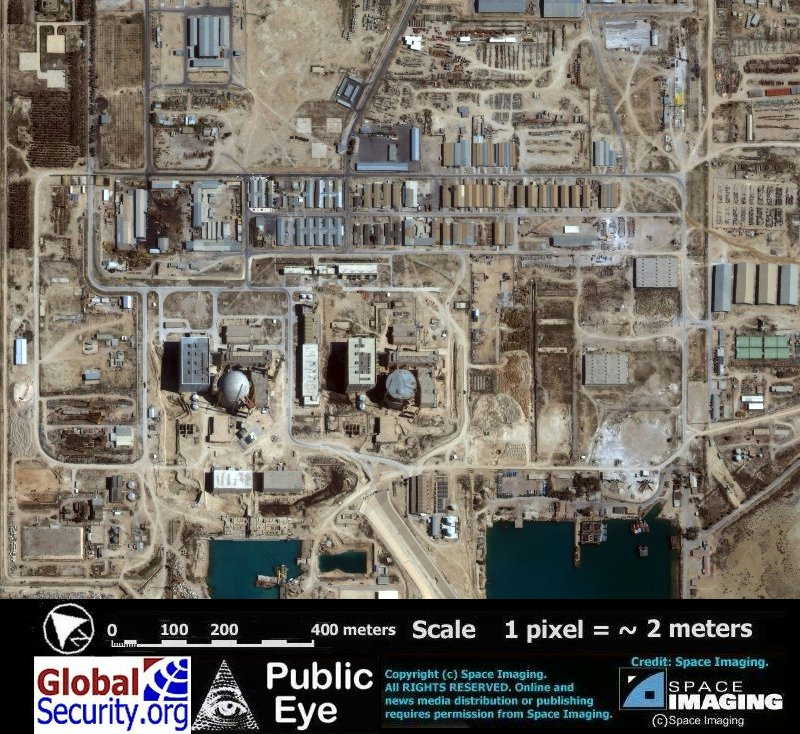
The above comes from the excellent IKONOS satellite of Space Imaging and it was obtained from the great website of Global Security. Global Security has a smorgasbord of information available on Iran’s Nuclear Program here.
Category: Geopolitics
Monday, January 16, 2006
Oxford's 2005 Year in Review
Ben Keene over at Oxford Press gives a geographical year in review. Some of the highlights include:
"Elsewhere on the continent, further name changes were made in three South African provinces, continuing the process of replacing the old colonial name forms with Africanized names that began several years ago. Most notably, the capital city Pretoria became Tshwane, meaning “we are the same” in 2005."
and
"Myanmar, a country located between India, China, and Thailand also made the news when its secretive and often paranoid government decided to move the entire capital city along with its official inhabitants from Rangoon, or Yangon, to isolated Pyinmana in the Mandalay division."
I, a geographer, did not know of these two changes. Makes me wonder what else I have missed. Read on and enjoy!
Category: Geoinfo
Sunday, January 15, 2006
New Old Map Creates New Questions on Old Issue
Scandinavians may smirk, American Indians may laugh, but a newly announced map may put Chinese explorers all over the world before the time of Christopher Columbus.
The map's owner claims it to be a 1763 copy of an original 1418 map which depicts the entire world. This would make the map based on the maritime travels Zheng He (aka Cheng Ho). He traveled, at the very least, around the Indian Ocean and even into parts of the
The book and program 1421: The Year the Chinese Discovered America by Gavin Menzies advances the claim He traveled to
There is a problem with the map however. If scientific tests prove the map is not a modern forgery, all that is proven is the fact that the map came from 1763. There is no way of finding out if the 1418 map existed. So for right now the issue of pre-Columbian Chinese travel to
So for the meantime we must be satisfied thinking that the Spanish, or Portuguese fishermen, or Vikings, or Irish Saints, or Indians, or the Kennewick man's people were here first.
On a side note there is one trouble thing I want to point out: Does no one like
Saturday, January 14, 2006
A Real Blog Mentions GTWC!
I would like to thank Curzon from Coming Anarchy for linking to Geographic Travels with Catholicgauze!
Shout-out to you Curzon!
---------------------------------------------------------------------------------------------------
Update: TDAXP has also mentioned GTWC! Thanks TDAXP! Now to take on the MSM!
Shout-out to you Curzon!
---------------------------------------------------------------------------------------------------
Update: TDAXP has also mentioned GTWC! Thanks TDAXP! Now to take on the MSM!
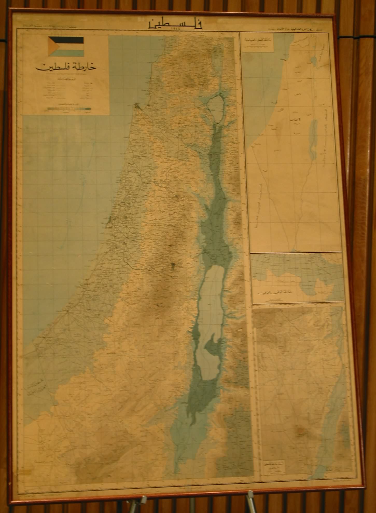
Being the UN means not having to make Geographical sense (or Catholicgauze Gets Angry!)
US Ambassador to the United Nations John Bolton recently criticized the United Nations for its showing a map of Israel labeled Palestine; never mind that Israel is a member of the United Nations.
Now I believe in the right of all people to have their own homeland under their own control in one form or another but this is getting ridiculous. The way the United Nations treats
If the UN really cared for its history or had any decency it would have shown a map of their proposal for both an
If the UN really cared about Palestinians maybe they would make sure Arab countries granted civil rights to refugees presently in nightmarish camps run by the UN. Currently only Jordan allows civil rights and all job opportunities to refugees. The other Arab countries like to keep Palestinians in camps to "preserve their identity."
Why does the United Nations not care for other groups? 3.8 million people have been killed and even more displaced by the Congo Wars but the only UN action seems to be establish a rape industry. The UN let Hutus kill Tutsis without batting an eye. The Roma in
On second thought maybe it is good the UN does not care for others. After all, their answer to the oppression of Shia and Kurds in
Category: Geopolitics
Thursday, January 12, 2006
Maps of the Faithful
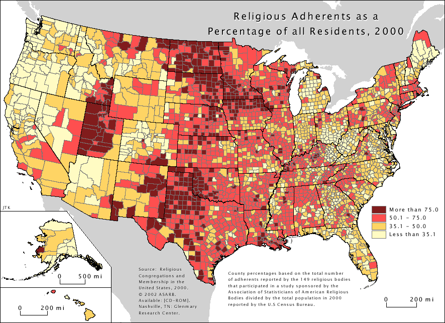
It is hard to figure out the exact religious make-up of the
The available maps include plurality religious group by county, religious attendance, and many more. Go see for yourself all the wonderful maps and ponder things like Baptist domination of the south and yet nothing else, the Dutch stranglehold on Northwest Iowa, and who just exactly are those Quakers of upper Alaska.
Category: Maps
Wednesday, January 11, 2006
A France from the Past
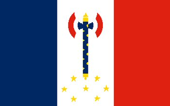
No, President Chirac has not declared his allegiance to the Orcish Horde and demanded war; the above is the flag of President Petain- the Fromage speaking, backstabbing, collaborator who led Vichy France during World War II.
I have recently stumbled across an excellent French website which contains maps of
Historical maps have always been an interest of mine and this website does not disappoint.
Category: Historical Geography Maps
Tuesday, January 10, 2006
Maps of an Israel to Come
Ever since high school I have been a fan of the Jerusalem Post (JPOST). While one can make the easy argument that its editorial staff is clearly on the Right of politics its news story have been neutral and the paper has taken a strong stance against Sharon/Likud corruption.
One of the things that make me especially like JPOST is its appreciation of geography. Maybe the editors know
The two maps that interest me the most are the maps (here and here) showing the security fence which
Israeli politics have been thrown a curve ball of biblical proportions with the sudden stroke of Ariel Sharon. No one yet knows what will happen to his pro-disengagement Kadima party. Whether the party can survive without
Category: Maps
Monday, January 09, 2006
Visiting Mecca
For those Muslims (or non-Muslim) interested in the Hajj or wanting more information on acutally visiting Mecca feel free to contact me or leave a comment.
------------------------------------------------------------------------
Unlike
One of the things to survive this urban renewal is The Prophet’s Mosque - the
Category: Virtually Travelling the World
Sunday, January 08, 2006
Traffic Jam in North Korea
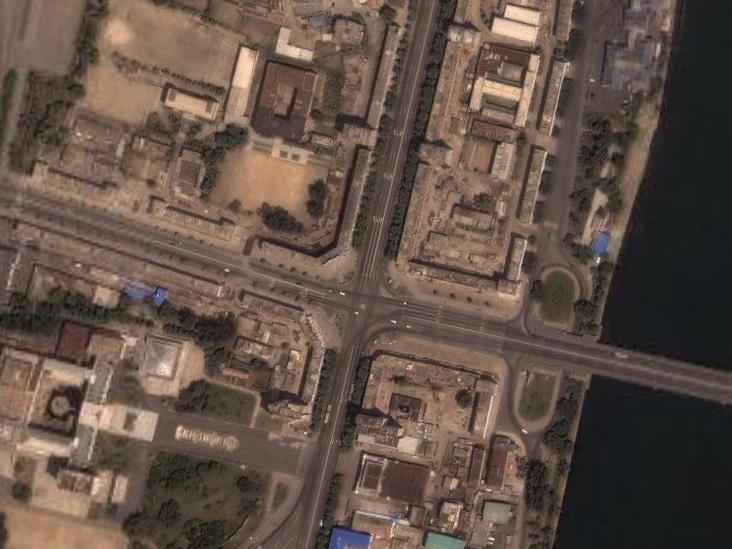
Glorious Leader Kim Il-Sung (with his son Kim Jong-il holding the position until he comes back from death) runs a clean and glorious country without fear of AIDS, pollution, or freedom for anyone.
The capital city of
Subscribe to:
Posts (Atom)