Global Positioning Systems (GPS) is everywhere these days. Businesses like the transportation industry, government, and even average people are utilizing the ability to locate there exact position on the earth.
When most people say GPS they actually mean NAVSTAR GPS which is run by the
Galileo is the new system on the block. A product of the European Union and European nationalism, Galileo's main purpose is to free
Wednesday, July 12, 2006
Global GPS


Tuesday, July 11, 2006
Megacryometeors
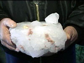
Over the skies of
The above is the story of a megacryometeor which recently fell on Douglasdale, South Africa. Megacryometeors are like humongous hail stones but we do not fully understand the science behind them. The largest megacryometeor recorded was about 440 pounds! Recently one landed in Oakland, California.
Here and here are good starting points for further research on megacryometeors.
Category: Physical Geography
Monday, July 10, 2006
Geography and Shakespeare
William Shakespeare is one of the best playwrights of all time. Many people know that Romeo and Juliet takes place in
While some consider him an archaic relic of a bygone time; he was made the transition of the neogeography age well. The Globe Theater can be installed into Google Earth or explore the mentioned places in Google Earth.
Finally, Google has a website with his complete works and links to more fascinating Shakespeare stuff.
Category: Neogeography, Books
Sunday, July 09, 2006
Hitler's Geopolitical Plan
The unholy trinity of monsters of the twentieth century goes Mao, Stalin, and Hitler. Mao's plan was focused on changing Chinese culture and Stalin was more of a thug than an ideologue. Hitler; however, had plans when it came to the rest of the world. While many people know about Mein Kampf Hitler had a second book. This one, named "Hitler's Second Book," described Hitler's foreign policy.
Here is a good point-by-point of Hitler's plot with commentary and historical results.
Step 1: Alliances needed to be made.
In the real world Hitler got one out of two as allies. He was disappointed by the outcome.
Step 2: The Roman-Aryans Axis would take down France and any of her allies like
The real Italian-German axis took down
Step 3: In Mein Kampf Hitler claimed the Soviet Union was
Never get involved in an Asian land war! I have learned that too many times in board games and Hitler should have known that. "That's Stalingrad; you wouldn't have any fun in
Step 4: It is not discussed in the Second Book but Hitler talked about forming a "European union" which would primarily benefit
Today's scorecard: European Union - check! Hitler as victor - blank.
Step 5: Hitler had nightmares of a sort of anti-Christ anti-Aryan state. He feared a country populated by Aryans but "controlled by Jews." This country was the
I bet Hitler really wished he had
Hitler order the book to be held in secret because openly publishing "I will destroy
Category: Historical Geography
Saturday, July 08, 2006
Location and Medical Geography
"For transplantation purposes, the U.S. is divided into 58 territories, each with its own supply of organs and demand for surgeries. To protect local access to organs, most donated within a territory go to patients waiting there, even if sicker patients are waiting elsewhere."
Be sure to read it all. You never know if it will one day save your life.
A New Imperialism to Create a New Africa
This is a Catholicgauze rant. Feel free to skip over it if you wish
As I wrote before I have a plan to fix
Before we start off here are some givens:
- Africa is in bad shape. Al Qaeda-allied pirates are increasing their attacks; dictators are starving their own people; and multiple atrocities are being committed which would make the Nazis blush.
- Billions of dollars of aid are being wasted every year by klepotmatic, corrupt regimes. It has been estimated that up to 9,000 people die a day due to poverty.
- Turmoil in
- Finally, it is better to teach a man to fish then to give them one.
First off the immediate deadly conflicts need to be ended. Whether by an international coalition force (the
The second step is to rebuild governments. This will be a long, several part plan starting off from pure imperialism, to transitional joint-government, to complete independence. The occupation government should be filled with people from political backgrounds (State Department-types), military types, and allied non-corrupt Africans.
The third step is also the first step for countries that need not be overthrown. It is also the main part of the new imperialism. It is an infrastructural imperialism. The political structure can be 100% native but all aid and infrastructure should be handled by foreign powers. This will be the condition of receiving any aid at all. The controlling power can be political countries or trusted groups like the Red Cross or Catholic or Anglican Church. Clinics, schools, roads, etc. at first must be in the hands of those who know how they can be operated. Eventually, the foreign civil servants can train natives to be their replacements.
While the infrastructural imperialism is in place the political overhaul should continue. Corrupt officials must be dismissed. The native armed forces should be built up so the government and foreign civil servants can be defended without foreign intervention from those who would try to destabilize the country.
Also at this point the AIDS crisis needs to be addressed. The deadly disease is being spread not only by horrible health conditions but also by bad cultural practices. In some areas of sub-Saharan
The end result on a case by case basis should be a more efficient government with a much healthier society. It is much easier said then done but people said the same thing could not be done with
The test countries, if successful, can then become key players in expanding nation building imperialism to neighboring countries. In short, a sort of domino effect.
Is the plan perfect, no. Are there other plans to heal
Category: Geopolitics
Friday, July 07, 2006
Review of Online Mapping Sites: Windows Live Local

Windows Live Local is Microsoft's entry into the world of online mapping sites and it is a decent one at that.
User Friendliness
Everything screams Windows user friendliness. The logo is that of Windows XP and the light blue hues are reused. Simple text boxes and easy to understand tool bars guide users. Third mouse button scroll is supported. To recenter one needs to right-click because a regular left click does nothing.
The zoom control is disorienting however. The image will become fuzzy then there is a load time to restore focus.
Driving Directions
Windows Live Local did standard on the long-term driving test. At the end it gave me directions which were slightly longer than they needed to be. However, directions were super clear and easy to understand. Also, information like "Entering Nebraska" was given.
The short term test was impossible to do. The street information of
Map Quality and Quantity
The map quality is above average. Things are clearly labeled and drawn. However, at high views everything looks like different shades of the same color. The aerial view is nice and Microsoft is not shy about using black and white DOQQs. The imagery in some places is dated though and lags behind Google's database.
Maps and directions are available internationally. Detailed instructions were given for a
What sets Windows Live Local is "bird's eye view." This is a very detailed and angled aerial shot. It is limited for certain cities. One nice thing is that the direction can be changed; for example, south can be at the top of the screen. However, scrolling is forbidden and the reorientation is not available for the map or aerial views.
Extras
It is clear Microsoft has much in mind for Live Local. Mash-up technology is in place and can be used in Microsoft's version of MySpace. Traffic is much better than Yahoo's. It is easy and customizable to share, print, or save maps and directions.
Summing Up
Microsoft has a potential winner on there hands. A little more tweaking and who knows what they can do with this.